My Munro Saga
by Frank Montgomery
Contents
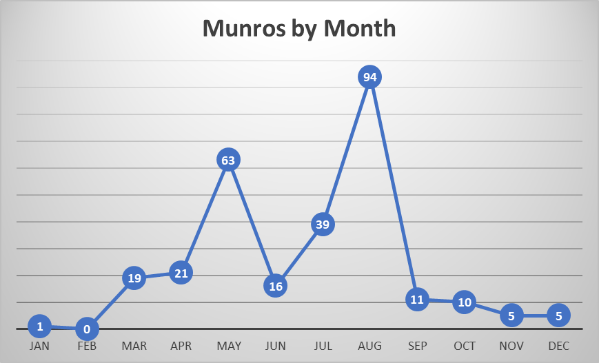
1975 Ben More: my First Munro (1)
1976 The Highest and the Hardest? (2-4)
1978 Dundee Days: A Grey Hill (5);
1981 A Grand Day in the Cairngorms (7-8)
1982 An Electrifying Experience (9)
1987 Lochnagar (10)
1988 Slip Sliding Away (11)
Wet Dry Wet (12-16)
1989 Winter Walking (17-18)
1990 The Mountain that Weighed the World (19)
1992 March Routes (20-21)
May Bank Holiday (22-27)
1993 Corrie Follies (28-29)
Glenshee Without Skis (30-34)
Soaked, Starving and Stranded (35-38)
Bread(albane) and Custard (39-40)
The Italian Job (41-43)
Halloween Hillwalk (44)
Underestimating the Dangers (45-46)
Nearly Hogmanay (47)
1994 April Fools? (48)
Lost in Conversation (49)
Forging a New Route (50)
Mayar & Driesh, Twins of the East (51-52)
Braw Days from Braemar (53-61)
Going Solo (62-70)
A Wild Goose Chase (71)
A Slightly Shorter Walk In (72)
1995 Lenten Walks (73-74)
A High Mark (76-81)
Knoydart and Kintail (82-85)
Orchy’s Treat (86-87)
Dehydrated in Scotland! (88-91)
A Jet, an Old Woman and a Window (92-98)
‘I Can’t Stand Munro Baggers’ (99-101)
Frozen (102-103)
1996 Comet(h) the Hour (104-108)
More from Newtonmore (109)
The Most Remote Munro? (110-119)
Nae Bother Atholl (120)
An Active Family Holiday (121-130)
Singing, Shuffling, Sheltering and Sprinting (131-142)
Peak of the Shellfish (143)
1997 Two Up One Down (144)
Peanut Butter and Chrysanthemum (145-154)
Rory’s First Munro (155)
Ten Munros and a Corbett (156-165)
The Douglas Returns (166-171)
A Noisy Munro (172)
1998 Back to Loch Quoich (173-175)
Complicated Logistics (176-182)
Ben Alder (183-188)
Factors Affecting Access (189-194)
Devils, Giants and Summer Snowballs (195-206)
1999 Dead in the Water (207-210)
The Wrong Daimh Dam (211)
Cannich Capers (212-215)
Skye Larking (216-221)
Benighted (222-226)
2000 Moving Mountains (227)
Fun in the Fannaichs (228-236)
2001 My Month of Pain (237-241)
Grey Skyes Are Gonna Clear Up? (242-244)
Better Weather in Strathpeffer (245-252)
2002 Lorn to Mamlorn (253-255)
The Black Chest (256)
Blisters (257-258)
2003 From the Complainer to the Bald Redhead (259-262)
Ticks (263-270)
2004 Forays from the Fort (271-272)
2005 Not That Coireachan, the Other One! (273-277)
Feeling Rough in the Rough Bounds (278-279)
MacKenzie’s Peak (280)
2006 The Penultimate Trip (281-283)
My Final Munro (284)
It was a great privilege to be asked to write a foreword to an account of my lifelong friend, Frank’s, ‘compleation’ of the Munros (Scottish mountains over 3000 feet high). Many (but not all) of these, we climbed together, as we both aimed for, and achieved, ‘compleation’.
Frank was an amazing companion – totally committed, always positive, often finding new ways to combine summits into ‘walks’.
Little athletic ability is required, and only in Skye are there a few ‘scary’ summits, but climbing nearly 300 mountains, each over 3000 feet high, involves a lot of walking. (It is perhaps appropriate to point out that Scotland’s not-too-unfriendly neighbour, with more than ten times the population, contains a pitiful six such mountains!)
Climbing Munros stretches the senses and provides the best days, but also the worst days, of your life. This is of course due to Scotland’s notoriously-varied weather, more extreme the higher you are. A gale-force headwind with torrential rain could be compared to the breath-taking beauty of an atmospheric inversion, when you are above the clouds.
It should be pointed out that climbing Munros is not a blinkered, numerical task, but more a framework, which often provides new and fascinating experiences and sights.
So, thank you, Frank, for asking me to write this. And to the reader, I am sure you will enjoy this account of one person’s ‘compleation’ of the Munros.
Chris Low
20 September 2022.
Writing this in 2020-22 has tested my memory to the limit. In what follows none of the events have been invented, and in the great majority of cases diary entries and photographs have helped to pin down dates. For the years 1976 and 1988 however, I cannot be certain of the correct order or year of some of the trips, but the narrative I have adopted seems the most likely.
Subject to the above, walk descriptions are arranged in chronological order (whereas the Table of Munros in the appendix is in height order). In the title line for each year, I have shown the number of trips, the number of walking days and the number of Munros successfully climbed. ‘Trip’ here means one excursion away from home (Glasgow, Bristol, Dundee or Leeds). Each trip is named and the numbers in parentheses show the running total of Munros climbed. There were 277 Munros when I started, 284 when I ‘compleated’ and only 282 now. For ease of identification, the name of each Munro successfully climbed is shown once in bold. There are quite a few places where the whole mountain has a name that is different from its individual Munros, and often the former is more familiar. I have therefore listed these cases in the appendix.
To gain a fuller appreciation of the walks, I would recommend following their descriptions on a map (online Bing Maps with ‘Road’ set to ‘Ordnance Survey’ is excellent). In some of the route descriptions I have given six-figure Ordnance Survey grid references, as described here. Note also that the photographs are annotated, but in order to read the annotations it is necessary to click on the individual photo – they do not show up on the ‘album’ view.
I graduated with BSc (Hons) Civil Engineering from Paisley College of Technology in 1973 and started work in April with the Consulting firm of Jamieson and Mackay, whose offices faced Kelvingrove Park in Glasgow. The company accountant was Bill MacKenzie, and at that time I had no idea of his place in the pantheon of Scottish mountaineering. The company pension scheme required that I sign a declaration of physical fitness, so I phoned Bill MacKenzie to ask what this entailed. He said ‘Can you do ten press-ups?’ I said I could, and Bill said ‘That’s fine then’.
Later that year Chris Low re-joined the Glasgow office after a spell with another company. We were both persuaded to join the Glasgow Ski Club by Sheila McKay, who had just joined as the partner’s secretary. This led to several ski trips to the Cairngorms, staying at either the Craiglynne Hotel in Grantown on Spey, or the Carrbridge Hotel. Quite a few of the club members were not regular skiers, but came to enjoy walking on the hills, or simply for the company. Chris and I took skiing lessons, but as the weather was often not suitable for skiing (too windy, or not enough snow) progress was very slow, and it was not until February 1977 when we went with the club for a two-week ski holiday in Val Gardena in the Italian Dolomites, that we reached ‘intermediate’ standard. But the Scottish ski trips (which included a few day trips to Glenshee with the Clarkston Ski Club) were my first opportunity to appreciate the Scottish Highlands from a height, and no doubt kindled my later enthusiasm for exploring them.
1975. Trips: 1, Days: 1, Munros: 1
So it was that on Thursday 17 July Chris and I set off to spend the Glasgow Fair weekend on Mull. We went in Chris’s VW Beetle, using the ferries at Corran and Lochaline - Fishnish, and camping in a site just up the hill from the centre of Tobermory. The weather was very good, being dry and sunny but a bit windy at times. I recall watching in fascination as a flotilla of yachts came in to Tobermory Bay, their flapping sails making quite a racket. On one very calm day, we thought it would be a good idea to hire a rowing boat and take it round the headland. There were none available that day but we booked one for the next. When we went to collect our boat the wind had got up, but we went ahead with the deal. After about five minutes, still in the harbour, we decided it would be imprudent to carry on, but it still took us about half an hour to get back to the landing slip. We bought some sausages for the next day’s breakfast and put them in the tent porch for safety while we drove to Calgary Bay. Of course, when we returned there was no sign of sausages, and we realised that the tent porch was not secure against hungry cats and dogs.
After these minor disasters, the ascent of Ben More was remarkably straightforward. At the time I was unaware of the existence of any lists of hills, and had certainly not heard of the Munros – it was not until Hamish Brown’s 1978 book that the general public became interested – but Chris was ahead of me, and was already in possession of a copy of Munro's Tables (now out of print). He was also ahead of me in the bagging game, having climbed Ben Lawers when he was a teenager. My own hillwalking experience then (age 26) consisted of Goat Fell (874 m) in 1974 and Tinto Hill (707 m) as part of a geology field day in 1971.
We parked on the B8035 at the foot of Gleann na Beinne Fada, and walked up that glen to the bealach, turning south to go over A’Choich, then approached Ben More from the east up quite rocky ground. I don’t recall meeting any other walkers on the way up, but there was a handful already at the summit shelter – a circular pile of stones which I suspect may once have been higher but was now about knee high. The view across the island to the Atlantic was superb, and no one was in a hurry to leave. However, this was in the days before digital cameras, when selfies were not even a thing. One had to ration one’s photos, as a typical ‘roll’ of film would allow perhaps 24 snaps, and the cost of film plus developing and printing was quite significant. Furthermore, a decent SLR camera was quite a heavy object to carry up a mountain so was normally, as in this case, left behind.
It is interesting to consider what was on my list of ‘essential’
hillwalking items in 2006 that I did not take in 1975: mobile phone; GPS unit; camera; mini
binoculars; first-aid kit; bothy bag; emergency bivi
bag; technical socks; gaiters; iron filings (emergency hand-warmer); Imodium;
SPF40 sunscreen; midge repellent; antihistamine; and for winter: ice-axe,
crampons and headtorch. Not much room
left in the rucksack for food and drink!
1976. Trips: 1, Days: 2, Munros: 3
The Highest and the Hardest? (2-4)
From 2 August 1976 to 27 Jan 1978, I was based in the firm’s Bristol office, so trips to the highlands became more difficult. However before leaving Glasgow, I managed to squeeze in a trip up the A82, again with Chris Low. We parked at the SYHA hostel in Glen Nevis, and soon joined the busy ‘pony track’ to Ben Nevis, also known as the tourist route. Chris was the leader on this walk, and suggested it would be more interesting to ascend via the north side of the mountain, so when we got to Lochan Meall an t-Suidhe we continued north-east on a lesser path that contoured round the north side of the Ben, taking us to the CIC hut in Coire Leis. This is a private mountain hut owned by the SMC. At that time it was fairly small, but from afar the most conspicuous aspect was the large stack of red gas canisters, which supplied propane for cooking and heating. (It has since been greatly enlarged, and now looks more like a hotel than a hut.) As we walked past, we said hello to some climbers preparing to tackle the north face, but they were too busy to notice us. The so-called rock architecture of the Ben’s north face is really quite stunning, and I was glad that we had taken this slightly longer route. We carried on up the deserted and gradually steepening Coire Leis, eventually scrambling until we reached a pole at the edge of a flat area where the Carn Mor Dearg arete joins the bulk of the Ben. The purpose of this pole is to facilitate abseiling down the corrie during winter. From the flat area it was one final push of easy scrambling to get to the summit plateau. As we crested the edge, we were suddenly confronted with the noise and bustle of scores of walkers, such a contrast with the quietness of our approach route. The plateau is littered with the remains of several buildings that once formed an observatory, as well as a trig point and more than one large cairn. Estimates of the number of days per year that the summit is cloud-free vary from 14 to 35, but sadly this was not one of them. Nevertheless it was calm and relatively warm, which is not often the case even in summer. Once we had finished our exploration of the ruins, we set off down the pony track (which had been constructed in 1883 to enable easier access to the observatory). This track has probably hosted a greater variety of strange and crazy adventures than any other in the UK. For instance in 1911 a model T Ford was driven to the summit and back, and at other times people have pushed or carried: a bed; a wheelbarrow; a beer barrel; a piano/organ; a Travelodge bedroom.
The next day we tackled the infamous Aonach Eagach. In her 1991 tv programme, Muriel Gray says ‘it’s an extremely dangerous ridge, and that’s why you shouldn’t be attempting it too early on in your Munro career’. Not having the benefit of Muriel’s advice, we hitched a lift from the Clachaig Inn (where we were staying) to the east end of the ridge and set off. It was a cloudy but clear day, perfect for hillwalking, and I recall being gobsmacked by the view to the north – over the Mamores to Ben Nevis – as we approached Am Bodach. The route from there to the first Munro (Meall Dearg) was narrow and rocky and included a tricky down-climb, which was just a taster for what was to come. The most difficult part of the ridge is between the two Munros, including a section known as the ‘crazy pinnacles’. I recall parts where it was necessary to hug the mountain and shuffle round a narrow ledge, and one short but intimidating section where the ridge was so narrow, and the drops either side so great, that we decided the only safe way to progress was ‘au cheval’, sitting on the knife-edge with our legs dangling over the sides. At another point the route was not obvious, and we were lucky that another more experienced climber caught up with us and showed us the way. Eventually we reached the western Munro (Sgorr nam Fiannaidh) but that was not the end of our adventures. Nowadays it is strongly recommended not to descend by the Clachaig gully (because the rock is so loose, and a falling chunk could injure or kill someone below), but this was before such sensible advice had been promulgated and we simply took what seemed the obvious and most direct route down. It was indeed very loose, and took quite a long time to descend, but thankfully there was no one below or above us and we managed to get back down to the Clachaig Inn before sunset for a celebratory drink or two. That day remains one of the most exciting in my life. In later years I harboured a desire to tackle it again, but now at the age of 73, although I still have the fitness to do it, I lack the bottle!
1977. Trips: 0, Days: 0, Munros: 0
As already mentioned, I was based in Bristol for the whole of this year, and although I did return to Glasgow for a few weekends, I never managed to make the extra distance to the highlands.
1978. Trips: 2, Days: 2, Munros: 2.
Dundee Days
At the end of January 1978 my contract in Bristol came to an end, and on 1 February I started work with Tayside Regional Council in Dundee. This meant I was closer to the mountains and also just a short drive across the Tay Bridge to St Andrews, where my old friend from schooldays, Gerry Quinn, was a lecturer in the Psychology Department at the University. My stay in Dundee lasted only eight months, but during that time Gerry joined me on two Munro climbing trips. He also joined me and some colleagues from Tayside on Saturday 17 June, when we walked from Linn of Dee to Coylumbridge via the Lairig Ghru – swapping cars at the end with another Tayside colleague who walked from north to south. Our route from Linn of Dee started out west, gradually curving towards the north, so the sun on this cloudless day was always on our left. Consequently for a few days I had sunburn only on the left side of my face, reminiscent of Richard Dreyfuss in ‘Close Encounters of the Third Kind’ which had been released the previous year!
My first Munro of this year was Carn Liath, part of the Beinn a’Ghlo range just north of Blair Atholl. Gerry and I parked at the end of the small public road at the north side of Loch Moraig. It was a dry but fairly breezy day, and as we headed eastwards on the uphill track, the west wind was growing stronger, so at the point where the path left the track (923678) we decided to continue on the track for about three kilometres more, then headed north so that we were on the lee side of the hill, and curved round to approach the summit from the east. It was very windy indeed at the summit and on the way down, but we had no problem following the path back to the car.
My second Munro of ’78 was the most easterly of all, Mount Keen. Friday 22 September was my last working day at Tayside Region before moving to Leeds, and on the following Saturday I met up with Chris, Gerry and Sue Wright (a PhD student from Gerry’s department), for a walk from Glen Esk to Deeside. Like the Lairig Ghru walk earlier that year, this was a two-car arrangement, with other Tayside colleagues walking the reverse route. We parked in the public car park in Auchronie, at the head of Glen Esk, and walked up Glen Mark, spending a few minutes at the attractive Queen’s Well monument which was built to commemorate a visit by Victoria and Albert in 1861. From there the track climbs northwards uphill towards Mount Keen. Where the track ends, two paths continue – one heads to the summit, whereas the other is the ancient ‘mounth’ road, which takes an easier lower route. Nowadays the easier route is hardly used, as most walkers are heading, as we were, for the summit. We continued north and after two kilometres the path became a track again following the Water of Tanar all the way to the tarmac road in Millfield where my colleague’s car was parked.
1979-1980. Trips: 0, Days: 0, Munros: 0.
From October 1978 until September 1979, I was studying for a master degree at the University of Leeds, during which I was encouraged to apply for a two-year contract as research officer. My original intention had been to return to Dundee, but the research job sounded interesting. Little did I suspect then that I would be employed by the University of Leeds for the rest of my working life! The combination of distance and pressure of work meant that the next few years did not lead to many ‘ticks’ in my list of Munro completions.
1981. Trips: 1, Days: 1, Munros: 2.
A Grand Day in the Cairngorms (7-8)
An advantage of working at the University was the generous holiday entitlement. Often I didn’t use my full quota, but in April 1981 I took advantage of the Easter weekend when the University was closed from the Thursday to the Tuesday inclusive. I drove from Leeds to Aviemore with my colleague Mike Hall, and we met up with Chris Low for a weekend of skiing. As it turned out, the weather was rather warm and the snow was patchy, so we only had one day of skiing, and instead enjoyed some good walks including a traverse of Cairn Gorm and Ben MacDui. We started from the ski centre car park in Coire Cas and walked up the normally snow-covered track to the Ptarmigan restaurant. (We could have taken the chair lift for this section but we felt that would be cheating.) From there we followed a well-constructed path to the summit of Cairn Gorm. The path was quite busy at the start, but I recall overhearing a group of youths discussing the merits of continuing, as it looked like ‘a bloody long way’, and sure enough by the time we reached the top the numbers were quite modest. There is an automatic weather station at the summit, and we arrived just as it sprang into action, a klaxon sounding before a hatch opened to allow measuring equipment to rise into the air. After this excitement we headed west then along the rim of Coire an t-Sneachda to the Fiacaill Buttress then south across the stony plateau for about five kilometres to the cairn and indicator at the summit of Ben MacDui. (This is the second-highest Munro, and for a long time it was thought by many to be the highest, until surveys in 1847 showed Ben Nevis was taller by 35 m.) The plateau is often wreathed in mist, but on this day we had excellent visibility and admired the other Cairngorm giants of Braeriach and Cairntoul on the other side of the Lairig Ghru. As the weather was so good, we had decided to take a more interesting route back, via Loch Etchachan and Loch Avon. We must have passed within a few metres of the ‘Shelter Stone’ refuge, but at that time I was not aware of its existence, so did not seek it out. We did however spend quite a while admiring the rock architecture (on a par with the north side of Ben Nevis), then after jumping across a burn we followed the path along the north-west side of Loch Avon for about half its length, taking the path rising gradually to The Saddle where we stopped for a rest and to admire the view. We still had a climb of 330 m to get back to the ski grounds so were quite tired but happy when we finally got back to our car, with 23 km under our belts. I was very pleased when Mike later said it was the best day’s walking he had ever had.
1982. Trips: 1, Days: 1, Munros: 1
An Electrifying Experience (9)
In August 1982 I met Chris Low in Aviemore, from where we drove up the now familiar road to the Cairngorm ski centre. Parking in the small car park at the first double bend, we set off southwards, crossing the Allt Creag an Leth-choin by a footbridge, then following a path across the slopes to the Chalamain Gap. At the gap, the ground changes from heather to loose rocks and stones, and the view ahead is narrowed. Once through, we could see the great pass of the Lairig Ghru, and the Sinclair Memorial Hut (removed in 1991) a little off the path through the Lairig. Although we were not in need of shelter, we popped in to the hut to have a look, but were not tempted to stay – it was one of the more spartan refuge huts consisting of just one small room. From there we continued up the ridge over Sron na Lairige, then turned west along the edge of the cliffs of Coire Bhrochain to the summit of Braeriach, the third-highest Munro. Up to this point the weather had been calm and dry and sultry, but at the summit I became aware of a tingling sensation in my hair (which was longer then!) and noticed black clouds building, so we made haste to get off the top as quickly as possible. Luckily there was no lightning strike, nor even any rain but I felt it was a close thing. We trotted quite easily down the ridge to the Sinclair Hut but then rather than climb back up to the Chalamain Gap we continued down the Lairig Ghru for about two kilometres then branched to the right to reach Rothiemurchus Lodge. From there a path took us eastwards through another gap – Eag a’ Chait – soon rejoining our outward route. With about one kilometre to go, I heard a snuffling noise behind me and turned round to see a reindeer closely following me! Since 1952 reindeer have roamed freely on the north side of the Cairngorms, and they are quite tame.
1983-1986. Trips: 0, Days: 0,
Munros: 0.
Plateau Predicaments.
From 28 December 1983 to 16 September 1985, I was based at the Asian Institute of Technology, Bangkok. The preparations in advance of this move left no time for Munros in 1983. Moreover on my return to Leeds I was appointed as a lecturer. This new role required a lot of preparation, on top of which I travelled for research projects or conferences to Cairo, Budapest and Bangkok in 1986, so no Munros were tackled in that year either. Nevertheless, I did organise a skiing weekend at Aviemore for the Early May Bank Holiday. My parents had been staying with me for ten days, so after driving them back home to Glasgow I met up with Chris and with Neil Douglas, a Lancastrian PhD student at Leeds. The Monday was not a holiday in Scotland, so Chris had to leave on Sunday evening to get back to work. The skiing conditions had not been very good, so on Monday 5 May Neil and I decided instead to walk up to the Cairngorm plateau. We followed a similar route to that taken by Chris and me in 1982, and shortly after passing the Sinclair Memorial Hut it began to rain, initially lightly but soon building to a downpour that soaked us to the skin and forced a retreat. Later that day while driving back south we heard on the car radio that a nuclear power station in Ukraine had exploded, and a radioactive plume had spread over northern Europe. It later transpired that the heavy rain had washed radioactive Caesium onto large areas of upland Britain, and restrictions (finally removed in 2012) were placed on the movement of over four million sheep. I did not restrict my movements, but I spent longer than usual in the shower that evening!
On another occasion Neil and I ventured onto the Cairngorm plateau in winter. The ground was covered in hard-packed snow and we were in the cloud but there was no wind. We set off from the Coire Cas ski grounds with a vague plan to reach Ben MacDui. I had a map and a very cheap compass which I used to navigate our way from Stob Coire an t-Sneachda south-south-westwards to where Lochan Buidhe lay frozen under the snow. At this point we decided there was no point in going farther, as visibility was so poor, so we turned round to head back by the same route. After about 200 m the clouds parted towards the east, revealing bare rocks at the head of a large corrie. I immediately convinced myself, against the evidence of the compass, that I was looking towards Stob Coire an t-Sneachda, so we veered to the right and headed for the rocks. On reaching them, a very long, deep glen was revealed, the bottom of which was level and white. This could not be a loch, as there is no loch in Coire an t-Sneachda! I surmised that there must have been a very heavy snowfall which had somehow ‘condensed’ to form this level plain. After a few minutes discussion with Neil, I finally agreed that I was seeing what I wanted to see rather than what was really there, which was of course Loch Avon. My heart sank somewhat at the realisation that we were at Hell’s Lum Crag and were about 500 m off course. I also realised that the walk had taken more out of me than usual, probably because I had only recently recovered from flu. Nevertheless I summoned up the energy to plod northwards to Stob Coire an t-Sneachda and thence to Coire Cas and safety. An important lesson was learned, which was to trust the compass rather than the eyes. It may be true that ‘seeing is believing’ but that does not make it real.
1987. Trips: 1, Days: 2, Munros: 1
This was another very busy year, with visits to Bangkok, Singapore and Kuala Lumpur. Nonetheless I managed to make time to plan a two-day expedition in early August, combining my first Munro for five years with a trek from Braemar to the Angus glens and back again.
On Friday 31 July I drove from Leeds to Glasgow, visiting my sister Ged in Wetherby on route. On Saturday 1 August I drove to Braemar where I met Chris and Gerry who had driven up together. On Sunday morning after an early breakfast, we left our guest house and took the path eastwards through woodland between Creag Choinnich and the Lion’s Face. Then after two kilometres along the A93 to Invercauld Bridge we followed tracks though the Ballochbuie Forest past the lovely falls of Garbh Allt, emerging at 205881. From there we took the ridge of Druim Odhar to just south of Sandy Loch and scrambled directly up the steep rocky slope of the north face of Lochnagar to its summit, Cac Carn Beag. This is not the normal approach route, and I think our sudden appearance surprised some of the folk who were already there. We were lucky to have clear, dry weather on both days of this trip, and the extensive views from Lochnagar were quite stunning – enough to justify a few photographs even then! Packed lunches consumed, we set off south-east on the stony path to Loch Muick. About 500 m from the loch the path gets a lot steeper as it goes through a ravine beside the Falls of the Glas Allt. We rounded the west end of Loch Muick and took the well-engineered path up Corrie Chash, briefly joining a track before heading downhill again on a winding path to Bachnagairn. From there the going was easier, on a decent track past the intriguingly named Juanjorge and eventually the public road at Braedownie. That would have been the end of our day’s walk had we been staying at the Glendoll youth hostel, but my companions were not keen on hostels at that time, so we had another five kilometres of road marching to reach the Ogilvy Arms Hotel in Clova. Since that time the hotel has been renamed the Glen Clova Hotel and upgraded to luxury class, but even in 1987 it was very comfortable. The next morning we had to retrace the road to Braedownie which, although flat, felt like hard work with our weary legs. But strangely once we started up Glen Doll and were walking on a path rather than an asphalt road, the feeling of tiredness faded away. We were now following ‘Jock’s Road’ back to Loch Callater and Braemar. At the top of the pass we ate our packed lunches, drinking water from a burn. We were less than a kilometre away from the summit of Tolmount, and could easily have ‘bagged’ that Munro, but we decided to leave it for another day. Reaching the A93 at Auchallater we crossed the Clunie Water by a footbridge and walked the last three kilometres down the unclassified road to Braemar and our guest house, a total distance of 30 km for the day and 36 km the previous.
1988. Trips: 2, Days: 4, Munros: 6.
On 9 April 1988 Chris and I met Gerry in St Andrews for a
trip to Glas Maol. I had been up Cross Fell (the highest peak of the
Pennines) a few days earlier, which was good practice for this. The normal approach route to Glas Maol is from the Glenshee
ski area, and indeed one of the ski tows reaches to within half a kilometre of
the summit. But Gerry was the trip
planner this day, and he was keen to show us a route that he had previously
taken, which was much quieter than the noise and bustle of the ski grounds. So we drove via the Tay Bridge and Kirriemuir
to Glen Isla and the end of the public road at Auchavan.
From there we walked northwards up a
good track to Tulchan Lodge, where we turned west to
follow the path up Shanovan Hill to Little Glas Maol from where it was about 1.5 km to the summit
of (big) Glas Maol. The hills were covered in snow, but it was
consolidated hard snow, making for very easy walking. On the return, we skirted Little Glas Maol to the north, and I recall being impressed by the
great trough of Caenlochan
Glen to our left. Unfortunately I
also became aware that I had drifted off to the left away from my companions –
I was walking along a hard frozen slope and my boots were barely providing
enough grip to prevent me sliding down over the cliffs. I decided not to panic, and to continue my forward
momentum and move slightly to the right where the slope was less severe. Thankfully this strategy worked, and we
reached Monega Hill without incident, and from there
back down to the car. But I felt I was
literally close to the edge that day – one of several occasions where recalling
the moment can still give me the shivers!
Less than two weeks later while driving my sister and her family along the M62 to Manchester airport – they had decided to emigrate to Canada – I had to swerve sharply to avoid a large wooden plank dropped off an overbridge by a couple of feral children. If it had hit the car, I would not be writing this now.
On 4 July 1988 Chris and I drove to Kinlochleven, staying at Mamore Lodge, an old hunting lodge once used by King Edward VII, which had gone a bit downmarket and was operating as a fairly spartan hotel/bunkhouse. Sadly, some years later it fell into disrepair and is now derelict, but on our visit it was clean and comfortable and very reasonably priced! This would be our first foray into the Mamores, a wonderful complex of ten (at that time eleven) Munros linked by sometimes quite narrow ridges. They lie between Glencoe and Glen Nevis, and on this trip our plan was to attempt the three Munros of Am Bodach, Stob Coire a’ Chairn and Na Gruagaichean, which were easily accessible from our accommodation without needing to drive. As we set off the weather was dry and sunny, and when we reached the summit of Am Bodach, quite a few people were there already. One teenager looked the worse for wear, and one of his party told us that he was diabetic and suffering from exhaustion. Nowadays that would be a medical emergency probably warranting a helicopter rescue, but this was before mobile phones, so his friends were simply planning to help him get down safely. We continued north-east, going steeply down the ridge to the bealach then up again to Stob Choire a’ Chairn where we had our lunch. Setting off again towards the east, the weather suddenly started to deteriorate, and soon we were enveloped in a rainstorm of tropical intensity, so much so that we abandoned our planned third Munro and headed straight back to the lodge. Looking back, the number of Munros I abandoned at the first attempt due to bad weather was fairly small, and I can recall only one other occasion when the rain was so intense, which was on the Ballachulish horseshoe two days later.
Our next hill day was to the Black Mount. We parked the car at Coupall Bridge on the Glen Etive road, less than a kilometre south of the A82. We then followed the SMC guidebook route, almost immediately fording the River Etive, which thankfully was not in spate! Our route crossed two small burns then headed up the long ridge of Sron na Creise (nose of Creise) to its summit, where we ate our sandwiches and admired the view across to Buachaille Etive Mor. About two kilometres later we were at the summit of Meall a’ Bhuiridh, which is the highest point of the Glencoe Ski area, and indeed one of the T-bars goes to within about 200 m distance from the top. It was quite strange to suddenly see all the skiing paraphernalia, which did look a bit out of place in summer. Our route took us north down the ridge to Creagh Dhubh, and thence back to our starting point. Unloading the car back at our B&B, I couldn’t find my rucksack, and eventually realised I must have left it on the ground back at Coupall Bridge. We drove back to check but there was no sign of it. However another chap who had just returned to his car suggested we should check with the police in case someone had handed it in. So we duly drove to the police station in Glencoe village to provide the details. In the meantime, as we had another walk lined up for the next day, I bought a cheap and rather colourful replacement rucksack from the outdoor store on the A82 in the village.
On our last hill day, the plan was to traverse the Ballachulish horseshoe, a great curved ridge with two Munros just south of the Ballachulish bridge. We parked in the village of Ballachulish and set off up the hill to Beinn Bhan from where we had a good view over the village to Loch Leven and the Pap of Glencoe poking through the cloud. We carried on up the ridge to Sgorr Bhan from where it was just a short pull up to the Munro of Sgorr Dhearg. We had our lunch at the summit, looking at the second Munro (Sgorr Dhonuill) and I remember being surprised that I could hear the conversation of a group at the bealach. Just as we started to head down the west ridge the rain started, got heavier and heavier, and Sgorr Dhonuill disappeared. We got thoroughly soaked and decided there was no point in continuing upwards if there was no view to be had, so headed north down the glen, soon picking up the forest track back to South Ballachulish then four kilometres along the road back to the car. It would be four years before we finally got to the summit of Sgorr Dhonuill. On our return to Glasgow, we called in at Glencoe police station, and I was delighted to find that my rucksack had been handed in.
1989. Trips: 1, Days: 2, Munros: 2.
At Easter 1989 Neil Douglas (now working in London) had organised a weekend with two of his colleagues at Achnashellach Lodge. At that time it was a hotel, and very close to the rail station, which was handy for Neil’s group whose jobs at TransEcon – part of British Rail – entitled them to free rail travel! I was invited to join them, and as I was already in Glasgow for Easter I accepted. No free travel for me, so I drove there, but set off without first checking the location on a map. I remember stopping in Garve to use a public phone box to phone the Lodge and ask for directions! The Lodge owner was not Scots but had pretensions to be so, and had therefore hired a young female piper to play during dinner that evening. If you have ever heard bagpipes played indoors you will know that simultaneous conversation is not possible. Neil’s group were not too impressed. The following day one of our party felt sick, but the rest of us had an interesting walk from Kinlochewe up the track to Lochan Fada and then back over trackless snow-covered ground directly south, arriving back at the track after sunset. We were glad to accept a lift from a friendly gamekeeper for the last few kilometres.
After another couple of days Neil’s colleagues had to return south, but Neil and I decided to drive up to the far north to climb Ben Hope, the furthest north Munro. We started by visiting the fine broch - Dun Dornaigil – by the roadside about six kilometres south of Loch Hope. We then took the path from Alltnacaillich onto the gently sloping Leitir Mhuiseil and continued north to the summit, which is on a little plateau with extensive views to the north. The path up had been fairly easy, but was snow-covered towards the top, and the summit was like a skating rink. We were therefore surprised to see a gentleman at the top with artificial legs. He did have a companion, but nevertheless it must have taken a lot of guts and determination to make that climb.
That evening we drove to Aviemore, and the following day drove up Glen Feshie past a herd of hundreds of red deer, to Auchlean. From there we ascended the fairly steep path to Carn Ban Mor, then plodded northwards though fresh deep snow along the ridge to Sgor Gaoith. The summit of this Munro is a rocky peak perched on the edge of a cliff falling down to Loch Einich. We found a few others at the summit admiring the stupendous view down into the depths of Glen Einich, but didn’t linger as it was rather cold, and a wind was getting up. We decided to take a more direct route back down, by heading west down the left of the Allt a’ Chrom-alltain. Unfortunately, as I was checking our route on the map, a gust of wind blew it out of my grasp, never to be seen again! Luckily there are no cliffs on that side of the mountain, so it was just a matter of following the burn back to the road, then a four kilometre hike back to the car.
The Bank (Holiday) of Mum and
Dad
On Saturday 27 May I drove up to Glasgow for the Bank Holiday, and on Sunday took my parents to Glencoe. My father (then 77) had had a few strokes by that time which had affected his memory, balance and mobility. My mother was a year younger and was physically in good shape but was on long term medication for depression. I thought that a trip to the west highlands would be good for both of them, and indeed it was. After enjoying the view of the Aonach Eagach from below, I drove up to the Meeting of Three Waters car park and walked with my mother down to the wooden footbridge and up to the deer fence stile leading to the Lost Valley. She would have been capable of crossing the stile, but we did not want to leave dad alone in the car for too long.
Eight Countries
At the end of January that year I had been in Barcelona for a two-day project meeting. Shortly after the winter walking trip I was in Brussels, then in mid-April I spent a week in Coimbra, Portugal, supervising the data collection of my PhD student. Mid-May saw me in Paris for another project meeting, and from 25 June I was working for five weeks in Bandung followed by a week working in Bangkok. At the end of August, I accompanied my parents on a visit to my sister Ged in Toronto and combined this with attendance at a conference there. Finally on 21 September I flew to Delft to present a conference paper. This explains why no more Munros were tackled after Easter.
1990. Trips: 1, Days: 1, Munros: 1.
The Mountain that Weighed the World (19)
I was staying with my parents in Glasgow over the Christmas 1989 – New Year 1990 period, and on 3 January drove up to Aberdeen where my sister Jo then lived. Neil again made use of his free rail travel and joined me there for some winter walking. Over the following three days we: climbed Lochnagar from Loch Muick (though I did not attempt to reach the summit this time); climbed Schiehallion; climbed Stob Binnein from the south (though again I forwent the summit). The Schiehallion walk was on 5 January, and we followed the standard route, starting from the Braes of Foss car park and following the path up the eastern ridge, with wonderful views over Loch Rannoch. Schiehallion is quite an isolated mountain with a simple conical shape, and because of this it was used in an experiment in 1774 to estimate the mass of the earth. Furthermore, contour lines were invented as part of the experiment.
1991. Trips: 0, Days: 0, Munros: 0.
In 1991 I was working in Thailand and Indonesia for eight weeks, which meant the rest of the year was more pressured. I was also at this time making arrangements for my elderly parents. In October I started on a buy-out arrangement with the University of Strathclyde whereby I worked there for one day a fortnight for the next three years. My day at Strathclyde was always a Monday or a Friday, allowing me to combine the trip with a weekend visit to my parents (now in hospital and care home) and occasionally (from 1992) with a Munro expedition.
1992. Trips: 2, Days: 6, Munros: 8.
This was another busy year for travel, with business trips
to: Turin in January and June; Brussels in February, April, June, September and
December; Dubai in April; Lyon in June/July; Indonesia in July - September (nine
weeks). Somehow
I managed to fit all this round my lecturing duties at Leeds and Strathclyde,
visits to my parents, and still have room for two Munro trips!
One of my Strathclyde days was 20 March 1992, the last day of term, so I had booked the following week as a holiday in the highlands. On the Tuesday I was in Dornie with Chris Low, and we drove south to Glen Shiel to climb Sgurr na Sgine. We parked at Malagan Bridge and headed along the track to the footbridge over the Allt Mhalagain, then headed south-west up the snow-covered ridge to Faochag. From this point we had a panoramic view of the Five Sisters to the north, The Saddle to the west, the South Kintail Ridge to the east, and our destination to the south-west. It was a cold day and the sun (which was not to be seen) would be setting about 18:00, so we did not hang about, and continued on round Coire Toiteil to reach the summit of Sgurr na Sgine from the north-west. Our return route was initially down the south ridge for about 300 m, thus avoiding the cliffs just east of the summit, then east to the Bealach an Toiteil where an old wall led us over Sgurr a Bhac Chaolais to the Bealach Duibh Leac. From there a very winding path snaked northwards back to the footbridge and the car.
On Saturday morning we drove from Fort William (where we had been skiing on Aonach Mor) through Glencoe, and parked at Lagangarbh south of the A82, near the river. From there we took the standard route to the top of Buachaille Etive Mor, straight up the gully of Coire na Tulaich. There was no snow at road level, but from about halfway up the mountain was covered in old soft snow. Luckily there were no icy patches, as at that time I had not got round to buying an ice axe or crampons. We reached the summit without incident, admired the view and headed back down. Of course, when I say ‘the summit’ I am referring to Stob Dearg, which was the only Munro on the Buachaille at that time. In 1997 the SMC added eight new Munros to the list, including Stob na Broige at the south-west end of the mountain, so a revisit became necessary.
At this time Neil Douglas was working abroad but came back to the UK for a holiday in May. I picked him up at Glasgow Airport (no free rail travel now!) on Friday 22 May for a long weekend of Munro-bashing. That same day we stayed at Rowardennan Youth Hostel and climbed Ben Lomond (the most southerly Munro) by the standard route. The weather was dry with broken cloud, and we had a good view of the Loch from the top. When possible, I like to return by a different route to the ascent, but we had only started walking at 18:15 and were keen not to become benighted, so we ignored the temptation of the Ptarmigan Ridge and retraced our steps, arriving back at the hostel at 21:30. An advantage of walking so late was that we avoided the crowds on this normally very busy Munro, and in fact the summit was deserted.
The following day we met up with Chris Low and drove to Glencoe, to the car park just west of the Meeting of Three Waters. We took the well-known path down to the footbridge over the Coe, and up into Coire Gabhail, better known as the Lost Valley. The way that the valley suddenly opens up as you emerge from between the last big boulders never ceases to delight. About halfway along the valley we headed left up to the crest of the Beinn Fhada ridge, and followed that to Stob Coire Sgreamhach (which would not be promoted to Munro status until 1997), the last part of this involving a fair bit of scrambling. From there it was a fairly easy ridge walk to Bidean nam Bian, the highest peak in the Glencoe area. This was actually my second time on Bidean, the first being with the Glasgow Ski Club on a summer outing, but I cannot recall any of the details except that we started walking from the Clachaig Inn. On the ’92 climb the weather was excellent with the cloud above the tops, which was just as well as the cliffs on its north side could be a hazard in mist. We descended carefully along the ridge to Stob Coire nan Lochan, then down that peak’s east ridge, curving to the north-east along Gear Aonach and then dropping down left to the floor of Coire nan Lochan, where a path led all the way to another footbridge over the Coe and back to the car. This area, also known as the Three Sisters, offers a tremendous variety of opportunities for walking, scrambling and serious climbing. Furthermore it is owned by the National Trust for Scotland, so access is never a problem.
After our day in Glencoe, we drove west and stayed overnight in North Ballachulish. On the Sunday the weather was still excellent, so we had high hopes of completing the horseshoe that Chris and I had abandoned on our first attempt. We parked just south of the village of South Ballachulish and followed the forestry road and path until it emerged onto the open hill where, rather than head to the bealach, we took a steeper, more direct line up to the north ridge of Sgorr Dhearg. From this narrow ridge we had an astounding view encompassing the Pap of Glencoe, Loch Leven and even Loch Linnhe. We could also see our second objective Sgorr Dhonuill rising behind its north-eastern spur. Eventually we reached the summit of Sgorr Dhearg and saw the classic view of Sgorr Dhonuill. The ascent looked quite intimidating but was actually quite straightforward, with some scrambling near the top. The summit was fairly level towards the west, and the views in that direction, while less magnificent than those from Sgorr Dhearg, were still amazing. Rather than retrace our steps, we continued west then north along the horseshoe. I recall a discussion with Chris who said he had read that it was not advisable to continue to the end of the ridge, as it terminated in cliffs. Looking at our maps that did not appear to be the case (hence the discussion!) but in any case, at about 033573 we left the ridge, heading east into the forest and picking up a track back to the car and then on to Taynuilt.
After a good breakfast at our B&B in Taynuilt we drove to the Falls of Cruachan rail station, parking in a small car park on the main road rather than the power station visitor centre’s car park, where signs discourage hillwalkers and warn that the gates are locked about 17:30 so you could be locked in! (The visitor centre is the start point for tours of the underground power station, still an unfulfilled ambition of mine.) We took the path under the railway and up beside the falls, eventually joining the track to the highly impressive dam, which we crossed to reach the west side of the reservoir. There was then an easy level walk of about a kilometre to the head of the corrie, which brought to mind walking this same track a few years earlier in deep snow. Apart from skiing, that had been my first experience of walking in deep fresh snow, and I was surprised at how much effort it took, and how it reduced our speed to less than half of normal. I also recall being impressed by the spindrift being whipped off the tops by the high winds, from which we were completely sheltered. But returning to May 1992, the weather was perfect, and we followed the path from the reservoir to the Bealach an Lochain, from where it was a matter of hopping from boulder to boulder to reach the airy summit of Ben Cruachan and its extensive views. The ridge leading to the next Munro, Stob Diamh, is quite narrow and rocky. The SMC guide suggests it ‘involves a little very easy scrambling’, but after a few Munros one learns that the SMC guide authors are masters of understatement! From Stob Diamh Neil and I headed south along the ridge for two kilometres then south-west to the reservoir, where we reconnected with Chris who had decided to descend directly from Stob Diamh. We had started walking at 10:00 and finished at 16:00. I then drove us to Glasgow Airport where Neil caught his 19:15 flight back to London. I was working at Strathclyde the next day and a half, and drove back to Leeds on the Wednesday afternoon.
Family Matters
My sister Ged and her family had emigrated from Yorkshire to Canada on 21 April 1988 and returned to Glasgow on 11 July 1992, staying with our parents who were then in their declining years. Ged was in need of a car, and I was about to depart for Indonesia for nine weeks, so I transferred ownership of my car to her. On return from Indonesia, I decided to see how long I could live without a car. I lived just five kilometres from my office and had already been cycling to work about three days a week but committing to do this every day whatever the weather was slightly daunting. I managed until the end of the year when poor weather crumbled my resolve and on 29 December I bought a used VW Golf in Glasgow almost as a distress purchase.
1993. Trips: 8, Days: 10, Munros: 20
After a series of strokes going back nearly 20 years, my father died of pulmonary thrombosis on 1 February. Initially my mother seemed to take the loss in her stride, but on 8 June she was re-admitted to Leverndale hospital.
On 8 April I drove to Glasgow for the Easter holiday, and on Easter Monday (12 April) I set off with Chris Low for a one-day trip to Ben Lui. Originally my brother-in-law Pat was going to join us but in the end work pressures ruled that out. We parked in the little car park off the A82 at Dalrigh and walked up the track past Cononish. A little farther on to our right was the site of a gold mine that had operated on a small scale in the 80s, and we had read that an application had been made to re-open it. As we made our way west, the great snow-filled northern corrie of Ben Lui dominated the view. There was very little snow at ground level or even on south-facing slopes, but this north-facing corrie had lived up to its reputation for holding snow through to June. We were not aware that this corrie is a favourite for winter climbers, but as we entered it, we spotted a line of holes made by a climber’s boots. Without thinking very carefully about it, we decided to use these holes as our route, rather than following one of the ridges. We made quite fast progress until a small rocky projection was reached, which we had to clamber over. That was the point at which we realised that we were near the top of a very steep concave snow slope, without crampons or ice-axe, and that a slip could spell disaster. Luckily the snow was in good condition – firm but not icy, and we were able to follow the climber’s steps to the top. From there we descended south-west on snow-free ground to the bealach and on up to Beinn a’ Chleibh. Our return route took us back to the bealach then contoured south-east to another bealach at the head of Coire Laoigh which we followed to rejoin our outward route at the Allt an Rund. In the end a very enjoyable day, but every time I drive to Tyndrum I look to the left and shake my head at the folly of going straight up that corrie!
On the following Saturday 17 April I drove with Chris to the Glenshee Ski Centre, but the snow was too patchy for good skiing, so we had two days of hillwalking instead. On the Saturday our target was Creag Leacach. I had already been to Glas Maol in 1988, but Chris had yet to tick it off, so we added it to our shopping cart. As soon as we got out of the Centre car park we strapped on our crampons. Perhaps not strictly necessary, but after the Ben Lui corrie and my close call on Glas Maol in ’88, I was glad to have the reassurance of twelve spikes on each foot. Our route was just south of the ski tows to Meall Odhar then south-east along a little ridge to the dome of Glas Maol. From there it was west then south following the remnants of a wall to Creag Leacach’s summit. To return we carried on the ridge, curving round to cross Meall Gorm then north to a small car park where we removed the crampons before walking two kilometres along the road past the old Devil’s Elbow back to the car. Starting at a height of 665 m, this was an easier day’s walking than most.
We stayed in the Fife Arms in Braemar, and on Sunday made an early start so that we could park at 148800 where a footbridge crosses the Clunie Water. Based on the previous day’s conditions, we decided not to wear crampons, though we still had them in our rucksacks. The weather was overcast but dry as we set off east along the path to the ruins of a little hut (from the early days of skiing), and thence south up bouldery slopes to the summit of Carn an Tuirc. We were fortunate that visibility was excellent, as the land form is like a rumpled blanket, and I imagine that (in those pre-GPS days) it would have been easy to get lost in mist. Next on the day’s list of four Munros was Tolmount, at the head of Glen Callater, then Tom Buidhe, just over a kilometre to the south, but as we swung west to avoid the intervening corrie, it was more like two kilometres walking. The area between these four Munros is not particularly picturesque, but from Tom Buidhe the distant views of the main Cairngorm massif and Lochnagar to the north were remarkably clear, and to the east we looked down the gash of Glen Doll, and the outlying peak of Mount Keen on the horizon. Last on our list was Cairn of Claise, about three kilometres west and the highest point of the day at 1062 m. From there we followed a ridge path south-west to a point a kilometre north of Glas Maol, where we took the northern end of the Monega Pass back to the car. The Monega is an ancient drove road and smuggling route and was used by Queen Victoria. We had used the southern end of it when we climbed Glas Maol from Glen Isla in 1988.
Soaked, Starving and Stranded (35-38)
Monday 21 June was a Strathclyde day, but as it was midsummer and the weather looked promising, I drove up to Glasgow on the afternoon of Wednesday 16th, and that evening continued on to Dornie, a total of 626 km (389 miles) in a day. The next day Chris joined me, and we drove separately 113 km to Poolewe, where I parked my car and put a Krooklok on the steering wheel, as I was going to leave it for two days while we made our first walk involving staying overnight in a bothy. We bought food for the walk, then Chris drove us both 39 km to the Dundonnell Hotel at the head of Little Loch Broom. After a cooked breakfast (the last hot meal for about 37 hours) we set off east along the road for about 500 m then struck up the hillside to our right, following a footpath that snakes along over Meall Garbh, then on pathless stony ground over a couple of minor summits to reach Bidein a’ Ghlas Thuill, the first Munro of the day. The summit was in cloud and the rain had started, but when we descended to the intervening bealach we enjoyed a spectacular view down to Loch Toll an Lochain, and across to Sgurr Fiona. The mist closed in again as we started to climb up, which was perhaps as well, as otherwise we might have been spooked by the enormous vertical drop to our left. Reaching the summit of Sgurr Fiona during a brief break in the clouds, our eyes were drawn to the improbable sight of Lord Berkeley’s Seat leaning outwards above the corrie far below. Our plan had been to traverse the Corrag Buidhe pinnacles but given the heavy rain we followed the advice of a group going in the opposite direction and took the avoiding path to the col about 500 m north-west of Sail Liath. From the col we enjoyed a grand view to the east over Loch Coire Chaorachain, before turning to make our way west into Coir’ a’ Ghamhna. The rain had now stopped, and we had splendid views of Loch na Sealga and beyond it the twin peaks of Beinn Dearg. We continued south until we hit the path leading to Shenavall bothy. As bothies go, this is one of the best, having several habitable rooms and a good fireplace (but no toilet!). Consequently it is usually quite busy, so we lost no time in bagging a decent sleeping place (no beds in bothies, just ‘sleeping platforms’ if you are lucky). As I extracted my sleeping bag, I discovered it was rather damp, as I had not yet learned the trick of lining the rucksack with a plastic bag. Fortunately the sun was now out, so I was able to hang it to dry outside. I cannot remember our evening meal, but it was probably something like cheese and ham sandwiches. Afterwards we sat on chairs (a luxury!) in the common room chatting with several others including a group of middle-aged gents who worked at RBS. Later we were joined by a loudmouthed gangrel who claimed he had been staying in the bothy for ten days and had another four to go. (This length of stay is against the spirit of the Bothy Code.) He regaled us with tales of his exploits, then moved on to expound his philosophy of life, which included a hatred for bankers and teachers. The group from RBS did not reveal their employment, and I also felt it prudent not to reveal that I was a lecturer! The group remained calm, but the atmosphere had become strained. We had a long walk planned for the following day (37 km plus two Munros) so wanted to make an early start. But being near midsummer, sunset was not until nearly 22:30 at this latitude, so none of the other bothy occupants seemed to be in any hurry to turn in. We retired to our sacks about midnight, but the hard platform and the continued chatter from downstairs meant that sleep did not come easily.
We rose at 05:00 and after a minimal breakfast were on our way at 06:00. The first obstacle of the day came three minutes later – the crossing of Abhainn Srath na Sealga, a river that is known for rising and falling very quickly. There is no bridge, so we took our boots and socks off and waded across - thankfully it was no more than knee deep. Socks and boots back on, we followed the Abhainn Gleann na Muice past Larachantivore, where we took the advice of the SMC guidebook by not trying to use the dilapidated old bridge there, but once more waded across to the footpath on the west bank. After 1.5 km we took the path up Gleann na Muice Beag to a level area studded with small lochs, crossing the outflow from the last of these to head up the path to Ruadh Stac Mor. At this point we had lunch (sandwiches and water) then as we were planning to return this way, we decided to make the ascent easier by leaving our backpacks on the ground. The path up to the col between the two Munros was quite easy going, then it was a short pull up to the red sandstone summit of Ruadh Stac Mor, and stunning views of the lochs and mountains of one of the few true wilderness areas of Scotland. Returning to the col, the climb to A’ Mhaighdean was longer but less steep, and the views from the summit were even more captivating.
The easiest way back to our backpacks would have been to retrace our outward route, but our OS map suggested a more direct route was possible, going north down to Fuar Loch Mor, then along its western shore. So we walked to the domed northern summit of A’ Mhaighdean and started down the fairly steep NNE ridge. At about the 900 m contour the ground changed from grassy to rocky, and concentration was needed to pick a safe way down over this outcrop into the broad gully below. After that it was a straightforward descent to the south side of Fuar Loch Mor, then over tussocky ground back to our outward path and the backpacks. Whether leaving the packs behind was a good move or not is a moot point – had we kept them on our backs we could have shortened our journey by two kilometres by going via Fuar Loch Beag.
After the elation of achieving our objectives and being treated to such wonderful views, we had to extract ourselves from the wilderness, and that entailed a farther 20 km walking. We started by visiting the Carnmore bothy and found that it hardly merited the description of shelter as the walls did not fully reach the ground. Shortly afterwards we crossed the causeway between Fionn Loch and Dubh Loch, then there was a long trudge to Kernsary during which I experienced a strange feeling of anxiety. This was possibly partly due to hypoglycemia, (from which I used to suffer) as we had rather badly underestimated our food rations. (I had not yet discovered the excellent ‘Mountaincraft and Leadership’ by Eric Langmuir, which allows estimation of the calories required based on distance and height gain, and also has a table of the calories supplied by various foods.) Another reason could have been the dawning realisation that I had left the key to my Krooklock in my evening clothes, in Chris’ car at Dundonnell! I decided not to tell Chris about my worries – he would find out soon enough.
Had we stayed overnight at Carnmore, the walk to Kernsary would have been perfectly delightful, with lochs to the right and mountains to the left. But at the end of a long day, it was something to be endured rather than enjoyed. Hence when we reached Kernsary and saw the young gamekeeper getting into his Landrover, we told him where we had been and asked if we could have a lift. Initially the gamekeeper was sympathetic, but then he said ‘Listen lads. I’m not going to give you a lift because you have almost finished your walk, and if I gave you a lift you would forever regret it’. And he was right! So we continued walking the last five and a half kilometres to my car in Poolewe, making a total distance of 37 km, probably the longest distance I have ever walked in a single day.
At the car, I feigned surprise at not being able to find the Krooklok key. The problem was that we had previously booked a B&B in Gairloch, about nine kilometres away, and now had no way of getting there. But I spotted that the house beside my car had a B&B sign in the window, so I knocked on the door and was enormously relieved to find that space was available for that night. So we quickly booked in then made haste to the Poolewe Hotel for dinner – it was nearly 21:00 so we were lucky to be served. From the hotel I phoned the prebooked B&B to apologise, then phoned the AA to explain the Krooklok problem. They promised to come the following morning even though it was a Sunday, and true to their word an AA man arrived at 10:00. He quickly removed the Krooklok, not by use of a skeleton key but by brute force, slipping a pipe over the end of the bar that hooked round the clutch pedal and pulling hard to straighten it. Later I was able to bend it back and continue using it – it had always been more of a psychological deterrent in any case.
Transport restored, I had to drive the 39 km back to Dundonnell, then we both drove back to Glasgow, and I arrived in time to visit my mother in hospital at 19:30.
Bread(albane) and Custard (39-40)
Over seven weeks working in Indonesia (from 8 July to 31 August) meant that there were no further Munro trips this summer, but Monday 6 September was another Strathclyde day, so by getting the train to Glasgow on the preceding Friday evening, I was able to squeeze in visits to relatives on the Saturday and a Munro trip with Chris on the Sunday. Chris drove us to a layby on the A85 near Auchessan, halfway between Crianlarich and Lix Toll. We followed the SMC guidebook route from there to Meall Glas, where we had good views of Ben More and Stob Binnein directly south. We then moved on to Sgiath Chuil, from where Stob Binnein was more easily seen, being less obscured by the bulk of Ben More. We had our sandwiches here, and Chris surprised me by producing a tub of custard for his afters!
At the time I was project manager of an EU funded research contract involving Italian partners. Two Italian researchers had been seconded to work in Leeds for a while, and one of them expressed an interest in joining me on my next trip to the highlands. So on the morning of Saturday 2 October Salvatore Conte joined me on the 10:19 train from Leeds to Glasgow. On arrival I made sure he got safely to his hotel, then I visited my mother in hospital. On Sunday morning at 08:30 Chris picked us both up and drove up the A9 to the Drumochter Pass, arriving about 11:00. We parked in the layby at 632755 (just south of the county boundary) conveniently close to an access to the parallel cycle route, which we followed south for 300 m then branched off on a track which in 200 m crossed under the railway, then up the left bank of the Allt Coire Dhomhain. This burn separates the Boar of Badenoch from the Sow of Atholl, and luckily the water was not deep, so we were able easily to cross over and ascend Sgairneach Mhor by its east ridge. As our starting height was 450 m it took us only about two hours to reach the 991 m summit, where we ate our sandwiches. It was quite cold and windy, and sunset would be about 18:45, so we pressed on to the bealach then up the ridge to Beinn Udlamain, the highest of today’s three Munros at 1010 m. From here we enjoyed grand views over the 25 km long Loch Ericht to Ben Alder (which is difficult to see from any road). Our last Munro A’ Mharconaich is easily recognisable from the A9, presenting a sheer cliff face to that side. (picture here from a later walk) We were approaching from the south-west, so could not see this face until we were at the summit, but it was worth the wait! It was now after 16:30 so we descended to Coire Dhomhain and reached the car about 18:00. On the return trip Salvatore was very complimentary about the Scottish mountains, but as he was a native of Turin in the shadow of the Alps, I suspect he was being polite!
Monday 1 November was a Strathclyde day, so I got the train to Glasgow on the Saturday and met Chris on Sunday – Halloween – for a trip to Beinn Mhanach, between Bridge of Orchy and Loch Lyon. We parked on the verge of the A82 just south of the private road to Auch Farm, with the stately cone of Beinn Dorain looking down at us. The track up the Auch Glen crosses the West Highland Way, then passes under a bridge of the West Highland Railway. It then crosses the Allt Kinglass a seemingly unnecessary number of times, in much the same way that the West Highland Railway line unnecessarily (in my opinion) takes an enormous horseshoe diversion here, rather than following the line of the A82. Shortly after Ais-an t-Sithean (the ruined former home of a Gaelic poet) we took the left track to its end, then climbed rocky slopes to the summit of Beinn a’ Chuirn. From there it was an easy walk to Beinn Mhanach, from where we could see part of Loch Lyon. Our return was directly south down a steep grassy slope to the watershed, then west along another track to retrace our outward route.
Underestimating the Dangers (45-46)
A fortnight later, on the back of another Strathclyde day, I was back on the hills with Chris, this time on the East Drumochter Munros. I had driven up from Leeds on the Saturday, fitting in an Institute for Transport Studies walk from Ilkley on the way. So on Sunday 14 November I parked in a layby on the A9, three kilometres south of Dalwhinnie station, and we set off along the old road to the former quarry at 902 m. Given that we started at 400 m and were on a reasonable surface, this was not the most demanding of walks. We were now on a featureless plateau, but our eyes were drawn to the unmistakable shape of A’Mharconaich to the south-west, its snow-covered rounded top and sheer cliffs looking like some giant had taken a scoop out of a monstrous ice-cream confection. We continued to follow the SMC guidebook route, which was directly south to A’Bhuidheanach Bheag, passing A’Bhuidheanach Mhor on our left. It may seem odd that the Bheag (small) top is higher than the Mhor (big) one, but this is by no means unique (see for instance Cac Carn Beag on Lochnagar) and happens because the adjectives refer to the general bulk rather than the height.
When we reached the Munro’s trig point, we met a middle-aged gent from the south of England who had walked directly up from the A9 at the Boar of Badenoch. He was proposing to follow the same route as us then back down the A9 but had neither map nor compass. We told him that we thought he was taking a bit of a chance at this time of year, but he seemed oblivious.
We backtracked to the old quarry site then a further three or four kilometres to Carn na Caim, the second Munro, just as uninspiring as the first. I would not recommend this walk in poor visibility, but we were lucky to have a clear day and enjoyed views of not only the Munros across the A9, but also the Cairngorms to the north-east. Possibly near the bottom of the ‘effort per Munro’ league table, if such a thing exists!
I was in Scotland for the whole Christmas - New Year period. My mother was now 80 and in care, but I was able to take her shopping on Christmas Eve, and to take her back to her own home on two occasions. I also managed to meet Chris for skiing at Cairngorm, and on the return journey we took in another of the Drumochter Munros. This time I parked at Cuaich, just north of Dalwhinnie, and we set off in full winter gear including ice-axes and crampons (the latter still in our sacks). We followed the good-quality track beside the aqueduct, which led to a small power station at the end of a pipeline and junction of paths. We continued east over a little bridge and in another kilometre arrived at the Loch Cuaich dam. Now there was a choice of routes, and we decided to ascend by the steeper route, as it is normally easier and safer going up steep slopes than coming down, especially in winter. So we took the track on the west of the loch then donned our crampons for the steep snowy slopes to the summit of Meall Chuaich. It is a fairly isolated peak, so we had good views as far as the Cairngorms. The return route was west for a kilometre then down a broad ridge to a small bridge and a bothy. This was not an MBA bothy, but possibly connected with the small power station. At this point we met a fellow who was just about to go up. We exchanged a few friendly words, and pointed out that it was already dusk, and would be pitch dark by the time he got to the top. He thanked us for our concern but carried on regardless!
1994. Trips: 7, Days: 12, Munros: 25.
At the end of 1993 my running total of Munros was 47, and it had started to become a bit more than a hobby, if not quite an obsession.
I drove up to Glasgow on Thursday 31 March for the Easter break. The following morning, I drove to Stirling to collect Chris who was now working there, and on to the Glenshee Ski centre where I parked up. The skiing was in full swing, and it felt slightly odd to be walking up Butchart’s Corrie rather than taking the T-bar. From the col, we descended to Loch Vrotachan, and as it was frozen, we decided to walk on it, as the surface was smoother than the path. We should probably have bored a hole to check the depth of ice, but instead we simply trusted our instincts, and it ‘felt’ safe. It was the first of April, but thankfully we were not shown up as fools! Once back on land we climbed easily to the midpoint of the two kilometre long An Socach ridge, then a fairly level walk to the summit at the west end. Somewhat unusually, we returned by the same route. The next few days were spent mainly with my sister and her children, then aged ten and six, including a couple of trips to the countryside with my mother.
On Thursday 7 April I set off on my own for An Caisteal, north of Loch Lomond. This would have been my first solo Munro, but shortly after setting off from the big layby on the A82 at 368238, I struck up a conversation with a taxi driver who turned out to have the same objective, so we agreed to stick together. The weather was calm and sunny, but the ground was covered in a thick blanket of recent snow which made for slow progress. We made our way along the snow-covered track then up to Twistin Hill, the ridge that leads to the summit. Our next objective was Beinn a’ Chroin, so we descended steeply south to Bealach Buidhe and then made a big mistake! We were engaged in conversation and not paying attention to the map, and somehow missed the ridge up to Beinn a’ Chroin, instead continuing south down into Coire a’Chuilinn. By the time we realised our error, it looked like a lot of hard work to climb back up to the col, so we decided to contour round to the west and over the col just east of Parlan Hill at 550 m rather than 800 m. So we saved ourselves a climb of 250 m, but at the expense of a lot more distance! We followed the Ben Glas Burn down to Inverarnan where we had a welcome drink at the Inn, then hitched a lift back to our cars. This walk was a good example of an apparently illogical rule of thumb: you are less likely to get lost on your own than in a group. The reason being that, on your own, you have no distractions and are motivated to pay attention to the map and compass. Whereas in a group it is easy to get caught up in conversation and miss a vital waypoint. Also it can happen that everyone in the group thinks that someone else is leading the way!
Whit Sunday, 22 May, saw Chris and me in Glen Etive to climb the reclusive Beinn Fhionnlaidh. Chris was doing the driving this time, as I had come up by train for a Strathclyde day on the Monday. We parked at Invercharnan and followed the SMC guidebook route along the good track through the forest, then over Meall nan Gobhar to approach Beinn Fhionnlaidh by its eastern spur. Just before the small summit plateau there was a bit of easy scrambling, and at the trig point there was a great view down to Loch Creran. The weather was dry and calm but hazy, so we could not see Ben More 60 km away on Mull. The guidebook suggests returning by the same route, but I thought it looked more interesting to continue west for 500 m, then north for 600 m following the ridge that curves round, eventually heading east again. There was a little scrambling at the start of this descent, but it was easier than that on the way up. Once off the ridge there was about a kilometre slightly uphill to a col, then down the glen to rejoin the forest track of our outward route, with views of Ben Starav on the way. I was glad to have taken this route back and am surprised that I cannot find it mentioned anywhere on the web.
Mayar & Driesh, Twins of
the East (51-52)
My next visit to Glasgow was to deliver a short course at Strathclyde on 8 and 9 June, but this was midweek, so a walk was not feasible. My next normal Strathclyde day was 20 June, and I came up by train on the Saturday. So once again the driving fell to Chris, and on Sunday 19th we drove up to Glen Doll. The weather was dry with broken cloud and sunset would not be until 22:09, so there were no time pressures. Parking in the Forestry Commission car park, we recalled our first visit to this glen in the summer of ‘87 when we walked Jock’s Road, and also just fourteen months ago when we looked down into Glen Doll from Tom Buidhe. Reminiscences over, we walked past the youth hostel (sadly now long closed) and took the path up the Shank of Drumfollow to the plateau. Driesh was just over a kilometre to the east over easy grassy slopes. After a bite to eat, we returned to the top of the Shank, and a farther two kilometres west took us to the summit of Mayar. The view from there across Corrie Fee to the Erne Craigs and beyond was quite spectacular. Our return route was down into Corrie Fee (a National Nature Reserve) picking up a track back to Jock’s Road. There is quite a difference in character between the eastern and western mountains of Scotland, and it was particularly evident on this walk. The western mountains tend to be rugged and bare, whereas those of the east are more rounded and grassy. Another important difference is the relative lack of midges in the east. If hillwalking in the west from May through September, midge repellent is a necessity if one intends to preserve one’s sanity!
Braw Days from Braemar (53-61)
Geoff Tweddle was a logistics expert who had recently joined the research staff of my department at Leeds. He was born on the north coast of Yorkshire, in a village that had since become part of Cleveland, and as a true Yorkshireman he always resented that! At one time he had been a rally car navigator, and still went to the occasional meet, but he was also a keen walker and I had been with him on a departmental walk from Dent to Ribblehead on 26 June. He had expressed an interest in joining me on my next Munro expedition, so on 22 July at 11:00 we set off from Leeds in his car. At that time most of my trips to Scotland were by rail, and to save space and weight on the journeys I was in the habit of storing my boots and other walking gear in my parents’ former home (where my sister Ged now lived). So although our destination was Braemar, we had to go via Glasgow. Chris was still based in Stirling and made his own way to Braemar. On the Saturday morning we drove to the Linn of Dee car park (which at that time was free) and set off northwards up the path through the forest, soon joining the track along Glen Lui to Derry Lodge, where we were surprised to see a public telephone box, surely one of the remotest in the UK. We crossed a footbridge and carried on up the north bank of the Luibeg Burn, to ford it just downstream of Luibeg Bridge. Thus far we had been on the main route to the Lairig Ghru, but here we left the path and climbed steeply up the broad ridge to Carn a’ Mhaim. We paused on the way up to take photos of the stunning views, and took even more from the summit. Clearly visible were Lochnagar, the Devil’s Point, Cairn Toul, Braeriach, Ben Macdui and Derry Cairngorm – possibly one of the best viewpoints in Scotland. Carrying on northwards along the now narrow ridge, we stopped at Allt Clach nan Taillear for a bite to eat then descended steeply to the Lairig Ghru and across the footbridge over the infant River Dee to Corrour Bothy. Nowadays this bothy has the luxury of a composting toilet, but in 1994 its facilities were somewhere between those of Shenavall and Carnmore (see 21 June 1993). Being on the Lairig Ghru it is very popular, and on our visit we were lucky to have arrived early. Geoff and I bagged a place on the stone floor, but as the weather was dry and warm Chris elected to sleep under the stars. Before turning in however, there was the important matter of food to attend to. Learning from our mistake the previous year, we thought we had provisioned enough for two days, and had a schedule of what to eat and when. Nonetheless after our ‘dinner’ of tuna sandwiches Chris was still starving and pleaded with me for more bread. I had to accede to his request, but only on the understanding that he would get less the next day! Obviously, we still had a lot to learn about catering.
Geoff and I had a rather uncomfortable night on the floor, whereas Chris had found a heathery hollow and slept well. We rose early and after a simple (uncooked) breakfast we set off up the steep path to the Devil’s Point. From there we could see a bank of mist pouring over into the Lairig from Ben Macdui. The sky was now quite overcast, and we crossed our fingers that it would stay dry. Returning from the Devil’s Point to the lip of Coire Odhar, it was about two and a half kilometres and a rise of 480 m to the summit of Cairn Toul, where we spent a whole hour admiring the views. Being mildly myopic I was initially sceptical of Geoff’s claim to have spotted walkers on Ben Macdui but with the aid of my mini-binoculars I confirmed that he was right. Realising time was moving on, we nevertheless decided it was worthwhile visiting the summit of Sgor an Lochain Uaine (Angel’s Peak) for its views, even though it was not then a Munro. (I was very glad of this decision in 1997 when it was promoted!) From there we went south-west down the ridge to the col just west of Loch nan Stuirteag, then up a steep slope to the flattish summit of Monadh Mor. This was not the most inspiring place, so we carried on south then south-east to the col at the head of Coire Cath nam Fionn, where we stopped for a brew-up. I had a small Camping Gaz cooker with me, which produced a good flame, but I had great difficulty getting it to produce enough heat to boil the water. In fact, it never did boil but became sufficiently hot to infuse the tea. I don’t think I ever took a cooker (or even a thermos) with me again, being quite happy with cold food and drink in the mountains.
Our last Munro of the day was Beinn Bhrotain, with a climb of 182 m and a distance of about one kilometre to the south-east. From the summit we went east to its other top, continuing down the broad ridge to join the path that leads from Glen Geusachan along the right bank of the Dee to White Bridge. We crossed this bridge to join a track taking us all the way back to the Linn of Dee car park. We had covered 27 km that day and 16 km the previous, so that evening we made up for the ‘iron rations’ with a slap-up meal in Braemar.
The next day was spent in Balmoral, including a tour of the distillery where we were shown a bottle of whisky that was for sale at £1000. We were not tempted by that but did buy some miniatures for use the following day.
Suitably recovered, on Tuesday 26 July we drove both cars to Auchallater (three kilometres south of Braemar), left Chris’ car there and went in Geoff’s car to the car park at Spittal of Glenmuick. From there we walked along the south shore of Loch Muick to the Black Burn, then stayed on the track that winds up the steep hill and along the edge of the plateau to the head of Corrie Chash, crossing the route Chris, Gerry and I had taken in ’87. About another two kilometres brought us to the domed summit of Broad Cairn with great views of Loch Muick and towards Glen Clova. Just over a kilometre west took us to Cairn of Gowal then in another kilometre north we reached Cairn Bannoch, from which we enjoyed views of Eagle’s Rock (but sadly no eagles) and could even see the sharp peak of The Stuic to our north. This was Chris’ 60th Munro and my 59th (as at that time we were not counting The Angel’s Peak) so a celebratory dram of Lochnagar whisky at the summit cairn was in order. From Cairn Bannoch to Carn an t’Sagairt Mor was about two and a half kilometres, and on the slopes of the latter we saw the remains of an RAF plane that crashed in unexplained circumstances in 1956. Descending west, we took the path leading down to Callater Lodge, and from there along the track back to Chris’ car. Before dinner however, there was still the matter of retrieving Geoff’s car from Glen Muick, 40 km away by road, compared to the 23 km we had just walked.
All in all, this was a very enjoyable trip. We were very lucky with the weather; the views were tremendous and everything went more or less according to plan. This would not always be the case!
On Sunday 7 August I put my bike in the car and drove up to Glasgow for a fortnight’s holiday. First on the list was a visit to my mother in hospital, then on the Monday I drove via Callander to Loch Earn, parking at Ardvorlich. It was already late afternoon when I started on the path to Ben Vorlich, but it was good weather, and the days were still long. I followed the SMC guidebook route up Ben Vorlich’s north ridge, meeting quite a few people coming back down. Descending from the summit to the Bealach an Dubh Choirein, I could see a party of three ahead of me moving very slowly. When I reached them, one was breathing very heavily and stopping every couple of steps. Perhaps they had started in the morning! The route to Stuc a’Chroin is quite steep and scrambly here but not dangerous as long as you watch where you put your feet. There was more than one cairn, one of which was erected in memory of Donald Stuart (founder of the Falkirk Mountaineering Club) and held a commemorative plaque. The views from here were splendid, and the hills were almost empty. I returned to the bealach, avoided a re-ascent of Ben Vorlich by skirting it to the west, and before heading down Coire Buidhe I turned round to get a dramatic view of Stuc a’Chroin showing its cliffs. I was soon back at the car and drove to Killin youth hostel where I would be based for the next three nights.
The next day I went for a ride up Glen Lochay to Kenknock, then north up a very steep track. My bike had plenty of gears but being a novice at mountain biking I found it very difficult to get started on a steep hill in a small gear, so ended up pushing part of the way. The track led to Glen Lyon which I followed to the lovely village of Fortingall. I had lunch there and visited possibly the oldest living thing in Europe (a yew tree which is estimated to be at least 1500 years old, but possibly more than 5000) then took the main road back to Killin beside Loch Tay, stopping at Lawers to check out parking possibilities for the next day.
On 10 August I drove up to the NTS visitor centre (demolished in 2012) near the summit of the minor road to Bridge of Balgie. I left the car in the large car park, put my boots on and cycled 10 km to the Lawers Burn just east of the Lawers Hotel, where I found a place to lock the bike. It was a warm sunny day, and I had not gone far along the track up the burn before I had to stop and remove my jacket. Shortly after that, I left the track and climbed up the grassy slopes to Sron Mhor, and on to Meall Greigh, first Munro of the day, from where there were splendid views of the Ben Lawers range and Lochan nan Cat (so named because from Ben Lawers it looks like a cat). The next Munro, Meall Garbh, was reached without difficulty, being less than four kilometres distant with a rise of only 290 m. From here there was a great panorama to the north and west, overlooking Glen Lyon. There was also a somewhat scary view of the next stage of the walk, up the almost vertical face of An Stuc. At the time An Stuc was not a Munro, and was not included in any of the detailed route descriptions in the SMC guidebook, so to some extent I was taking a chance that it would be a scramble and not a proper climb. Apparently there is a route up the west side that does not involve scrambling, but I was unaware of it and just went straight up the north-east face. It was a proper scramble but there were plenty of good holds so I never felt in any danger, however I felt it would be a different proposition coming down that way! The descent to Bealach Dubh was very gentle in comparison, then there was what felt like a long slog over Creag an Fhithich to reach the busy summit of Ben Lawers and its cairn. There have been several cairns here over the centuries, including a 6 m high cylindrical structure built in 1878 by Malcolm Ferguson in a vain attempt to raise the height of the mountain to over 4000 feet. (Vain, because the Ordnance Survey do not take artificial structures into account in their measurements of hill heights.) The present cairn, unlike most, is set in cement, and used to be topped by a direction indicator. My next two Munros were now easily visible. Beinn Ghlas was reached by a very well-worn path, and the smooth grassy slopes on its western flank made it easy to see why in the 1930s it was the centre of Scottish skiing. My last Munro of the day was Meall Corranaich, which used to host what would probably nowadays be rated as a black ski run. The Scottish Ski Club constructed a hut on the western slopes of Beinn Ghlas, but in the 1930s there was no mechanical uplift, so every downhill had to be paid for by a trudge to the top carrying heavy wooden skis. My uphill trudging was finished for the day, as it was now four kilometres downhill to the car, then back to the start of the day’s walk to retrieve the bike. That evening I had dinner in the Killin Hotel and got into conversation with a botanist who spent a lot of his time recording specimens on the Ben Lawers range. The south side of the range is a National Nature Reserve, owned by the National Trust for Scotland, and is famous among botanists for its collection of rare arctic-alpine plants and lichens.
The following day was almost a rest day in comparison. I parked about a kilometre south of the Lochan na Lairige dam, on the track that leads off to an old quarry. I followed the SMC guidebook route, reaching Meall nan Tarmachan fairly quickly and then taking my time to amble along the ridge enjoying the fine views. On the return, the views of Ben Lawers and Loch Tay amply compensated for the rather unexciting nature of the quarry track.
That evening I drove back to Glasgow and stored the bike at my sister’s house so that the next day there would be room to take my niece Laura and nephew Rory (then ten and seven) with me to Leeds for a long weekend. I must have been missing the hills already, as we took a diversion on the way south to climb Pen y Ghent (from the easier east side).
On Monday 15 August I drove back to Glasgow with Laura and Rory and retrieved the bike. I spent the next couple of days as houseguest of Gerry Quinn in St Andrews, (making a solo cycle ride to the lovely town of Falkland) then three days with my sister Jo and her husband Steve in Aberdeen, where we all saw the wonderful Eric Sykes in a play at His Majesty’s Theatre. Rather than take the direct route from St Andrew’s to Aberdeen I had gone via Glenshee, with the intention of bagging the Munros of Carn a Gheoidh and The Cairnwell. I parked in a layby a kilometre south of the old Devil’s Elbow and headed up the south-east ridge of Carn nan Sac, from where it was an easy stroll west to Carn a Gheoidh (Hill of the Goose). While on the tops I noticed dark clouds approaching from the west, of the type that suggests a thunderstorm is imminent, so I abandoned my plan for The Cairnwell and retraced my route back to the car, arriving just before the downpour.
A Slightly Shorter Walk In (72)
There was a series of rail strikes during September, but nevertheless on Friday 9th I took the train to Glasgow for a day of hillwalking and a visit to my mother. On Saturday 10th Chris drove us to Spittal of Glenshee where we parked in the little loop of road off the A93 (which was actually the main road before improvement). From there we walked along the track on the north side of the Shee Water, continuing north up Gleann Taitneach to Loch nan Eun, which we skirted to the west, then climbed to the bealach just south-west of Beinn Iutharn Bheag. We then headed west to the bealach south of Beinn Iutharn Mhor and finally climbed up the ridge to the summit. In total this walk was 14 km with 730 m of ascent compared to 15 km and 900 m of ascent via Glen Ey, which was the SMC guidebook route. Our return route was simply the reverse of the outward, thus we saved a bit of walking, and 63 km of driving. We stayed that night in Pitlochry, and on the Sunday morning I caught a train back to Glasgow, visited my mother in the afternoon, then caught the 18:50 from Central arriving in Leeds at 23:30.
1995. Trips: 9, Days: 20, Munros: 31.
My mother died on 20 March aged 81, and the next day I drove up to Glasgow to make arrangements for the funeral and to settle her estate. Some months earlier I had organised a trip to Aviemore for members of my department at Leeds, from 24-28 March. My mother’s funeral was on the morning of 24th, and I decided not to pull out of the Aviemore trip as there was a fair chance it would lift my spirits. So that evening Geoff kindly made a diversion to pick me up on his way to Aviemore. On Saturday 25th Geoff, his friend Dave Shackleton and I decided to climb Mullach Clach a Blair, on the Moine Mhor above Glen Feshie. We drove to the road end at Auchlean in Glen Feshie and set off south along the path by the river, ice axes in hand and crampons at the ready. At Carnachuin we turned east, following the track by the Allt Coire Chaoil which climbs steeply up to the edge of Coire Garbhlach, affording superb views into this deep gash in the flank of the Moine Mhor. It was a cold, cloudy and windless day and the plateau was covered in hard snow, so we donned our crampons. Visibility was quite poor on the tops, the path was covered in snow and our target was a rounded swelling rather than a peak, so we used Dave’s GPS to determine our exact location and took a bearing to the Munro summit. It felt like quite an achievement to find the cairn in the expected place! The return was easier, simply retracing our outward tracks, and on reaching the valley floor we were treated to the sight of a large herd of deer.
The weather was not conducive to skiing on Sunday, so we
took a low-level walk to visit Ryvoan bothy then
climbed the nearby Meall a’ Bhuachaille. On the Monday we walked round Loch an Eilein in the morning, and I had a half day skiing in the
afternoon. On Tuesday it was time to depart,
and most of our party went straight back to Leeds, but Geoff and I proposed to
fit in the ‘easy’ Munro of Geal Charn (Monadh
Liath) on the way. My memory of the
walk was hazy to non-existent, even as to our start point, so I asked Geoff
what he could remember. He replied:
Hi Frank,
The answer is Garva Bridge [the end of the tarred
road to Corrieyairack], as snowmelt meant the Spey Dam alternative may have
been risky. From the Bridge we went up
the track and stalkers path, then up the ridge direct to the summit. As usual your accurate compass work led to the
summit. Somewhere I may still have a slide of you at the
summit in the blizzard/spindrift which appeared on what started as a
beautiful day. I led part of the climb
(was it the first time?) because you tired in soft snow which was heavy going. The descent was roughly a reverse of the
climb. Another thing I remember of that
day was that you heard water underneath us. I’ve never had good hearing, and you used your
axe to smash through the surface to reveal a stream below us!! Then as we drove back along the valley a herd
of red deer were jumping the fences as they descended from the harsh conditions
in the hills. Hope above jogs a few
memories. Geoff.
Indeed, it jogged a memory of my touching the cairn and then immediately turning to go back down. Geoff must have persuaded me quite hard to stay for a photo! Once back in the car Geoff dropped me at Newtonmore railway station where I caught a train back to Glasgow to continue probate matters, then drove back to Leeds the next day.
I drove up to Glasgow for the Easter weekend, and on Good Friday (14 April) I drove to Aviemore with my sister Ged and her two children, for two nights in a family room at the Youth Hostel. On the way to Aviemore we stopped at Balsporran Cottages on the A9 just north of Drumochter Summit, to climb another Geal Charn – the second in less than a month! I had chosen this Munro as it was one of the easiest, and there were no cliffs or similar dangers to avoid. However it was April and there were still patches of snow on the slopes. Laura was eleven and Rory was not quite eight, and they were both excited at the prospect of climbing a mountain. We crossed the railway at the level crossing (wrongly shown on the OS map as a bridge), had fun jumping over two small burns, then followed the path up Geal Charn’s north-east ridge. With about a kilometre to go, the wind got up and Rory started to complain of the cold (despite having lived for nearly five years in Canada!). Suddenly a gust nearly blew him over, and he uttered the immortal phrase ‘Mum, are we going to die?’. ‘Of course not’ said his mum, but it was nevertheless agreed that ma and the weans would leave me to go on to the summit on my own, while they headed down southwards to pick up the path on the north bank of Allt Coire Fhar. From the barren and windy summit, I had a good view of Loch Ericht and farther to the west, Loch Pattack under heavy clouds. Having touched the summit cairn and taken my photos, I headed down and soon caught up with Ged and the kids, who were a lot happier now that they were in the less exposed corrie. At one point while crossing a boggy patch, one of Laura’s boots got stuck, and she pulled so hard that it came off her foot! But apart from that there were no further incidents, and the photo of Rory back at the level crossing shows that he enjoyed the experience.
One of my PhD students, Mark Powell had expressed an interest in joining me on a Munro trip, and I had agreed that the early May bank holiday would be a good time. I drove to Glasgow on Friday evening, and we stayed overnight at my sister’s house. On Saturday 6th May we made an early start and drove via Balquidder to Inverlochlarig. The weather was sunny and calm: Loch Voil was like a mill pond, and its shore was studded with the tents of weekend campers. We were lucky to find a space in the small car park at the road end and set off westwards passing the site of Rob Roy’s house before heading north-west up the grassy slope towards Beinn Tulaichean. Near the top there were crags to be avoided, but there was no difficulty in reaching the summit. From there the walk along the ridge to Cruach Ardrain was almost a stroll, and in fact the SMC guidebook casts doubt on Munro’s decision to classify these as two separate mountains. We had some lunch at the summit, then headed south to the bealach with Stob Glas, turning north-west there into Coire Earb. We then curved round under the crags, descending to about 500 m before starting the ascent of the north ridge of Beinn a’Chroin. This Munro has two tops one kilometre apart, and at that time the eastern top was considered the higher, so that is where we went, ignoring the western top. In 1999 a re-survey found that the western top was actually the higher, so I had to come back in 2000. From our false summit it was a straightforward descent down soggy grassy slopes to a track by the River Larig back to the car and Crianlarich youth hostel.
On Sunday 7th we met up with Chris Low and drove via Bridge of Orchy to Victoria Bridge at the west end of Loch Tulla. A short walk along the track by the River Shira took us to the start of a stalker’s path heading north beside the Allt Toaig all the way to the summit of Stob a’ Choire Odhair. The weather was still good, so we enjoyed good views of the non-ski side of Meall a’ Bhuiridh to the north, the Glencoe mountains to the north-west, and to the south-east the West Highland Railway snaking its way between Loch Tulla and Beinn an Dothaidh. After sandwiches we set off down the west ridge to a rocky bealach then up a curved ridge to the ‘other’ Aonach Eagach. The name means ‘notched ridge’, and it required some care at the narrowest part, but the dangers were much milder than those of its more famous namesake, and we were soon at the summit of Stob Ghabhar. The SMC guidebook suggested returning by retracing steps for 300 m then descending the south-east ridge, but we decided instead to continue west along a narrow ridge to Sron a’Ghearrain. About 200 m along this ridge another ridge heads off to the north then north-west for five kilometres – no wonder it is called Aonach Mor (the big ridge). I regret never having walked it (so far!). From Sron a’Ghearrain we headed south, soon picking up a path leading to Clashgour, and thence on the track back to the car.
Chris had returned home on Sunday evening, so on Monday 8th Mark and I checked out of Crianlarich youth hostel and drove south to the Rest and be Thankful car park. We walked east along the main road for about 200 m, struck north up the hillside for about 600 m then followed a rising traverse below the cliffs on the north-west flank of Beinn Luibhean, taking us into the un-named corrie between Beinn Luibhean and Beinn Ime. From there a bit of mild scrambling got us to the summit cairn, where we rewarded ourselves with a spot of lunch. Our next Munro Beinn Narnain was three killometres to the south-east along a well-used path across the Bealach a’ Mhaim. Mark had quite a calm demeanour, but on reaching the summit he was so taken with the views of Loch Lomond, Loch Long and The Cobbler that he was heard to exclaim ‘Blimey!’. Descending back to the Bealach a’Mhaim, we resisted the temptation to have a go at The Cobbler as we had to drive back to Leeds that evening, instead continuing down Coire Croe to the A83 which we walked along back to the Rest and be Thankful. This was probably the most dangerous part of the whole walk, as this fast busy road has no footway – in retrospect we would probably have been better to continue a little farther down to the old military road which runs parallel, and which in recent years has been brought back into service during the all too frequent occasions when landslides have blocked the main road.
Knoydart is on the mainland but there is no way of getting there by road. The usual access routes are: a long walk-in from Kinloch Hourn; an even longer walk-in from Strathan (west end of Loch Arkaig); thrice weekly ferry from Mallaig to Inverie. Some months previously I had discussed logistics with Chris, and we had agreed that our preferred option was none of these, but rather to hire the small ferry service from Arnisdale to Barrisdale run by Len Morrison. The cost was £22 each way, but with two of us we felt that was good value.
I had driven to my sister in Glasgow on Friday 19 May to deal with family matters, and on 23rd drove to my other sister in Aberdeen for three nights. I had brought a pile of coursework from my office, and managed to finish marking it for posting back to Leeds on 25th. While in Aberdeen I bought the tent (which I still have) for the Knoydart expedition, and also enough food for three days. (Our planned campsite was only two kilometres from the ferry drop-off point, so we felt we could carry in a lot more than would fit in our backpacks, simply using plastic shopping bags.) Thus on Friday 26th I drove nearly 300 km from Aberdeen to Glenelg. Meanwhile my brother-in-law Pat had planned to join our expedition but had had to pull out as he was still recovering from a virus. Nevertheless he insisted on keeping his promise to give a lift to Chris. We all met up at our B&B and had a good meal and a few drinks in the Glenelg Inn before retiring for the night.
The following morning Pat set off for a long drive home, while I drove Chris the short distance to Arnisdale where we located the ferryman’s house and parked the car. At 09:30 we loaded our gear into what seemed like a rather small open boat with an outboard motor. As we cast off and headed east close to the shore, a shag was flying over the loch just inches from the surface. The ferryman’s dog ran along the coast beside us until we got to A’ Chiste Dhubh where the dog was brought aboard for the short crossing to the boat house at Fraoch Eilean, at the end of the track from Barrisdale. As we approached the boat house we could see the estate manager and his assistant with a Landrover and trailer, and on arrival these two gentlemen offered to give us a lift to the campsite, providing we were happy to sit on the trailer. We readily accepted their kind offer, and hurriedly transferred our rucksacks and food bags to the trailer. After a bumpy two-kilometre ride to the campsite we unloaded our gear and realised with dismay that Chris had left his boots on the ferry, which had already left. The manager reckoned there was no way that the ferry would come back but said he might be able to help by lending Chris his spare pair of boots. So while we set up our tent he went off to his house and half an hour later re-appeared with a top-class pair of boots which fitted Chris perfectly! Before he left us, the manager advised us against climbing Ladhar Bheinn via Stob a’ Chearcaill as, in his opinion, the latter was dangerously steep and exposed.
The campsite was beside a rather good non-MBA bothy and being a bank holiday weekend, our tent was just one among many. However there was no community atmosphere, everyone keeping to themselves and pretending they were alone in a wilderness. The bothy had a proper toilet which we were allowed to use, but our water for cooking and washing came from the Allt a’Chuirn.
Once we had set up camp and re-packed our sacks with what was needed for the day, we set off to climb Ladhar Bheinn, which the SMC guidebook describes as ‘one of the finest mountains in Scotland’. We had a dilemma as our friendly estate manager’s advice regarding Stob a’ Chearcaill was in contradiction to the guidebook, although the latter did advise that ‘for 100 m there is a scramble up broken rock and grassy ledges’. Bearing in mind the guidebook’s penchant for understatement, we nevertheless decided to take our chances. Crossing the River Barrisdale by the track bridge, we followed the footpath north-west to the foot of Creag Bheithe, then followed this south-west to reach the 100 m pitch mentioned above. It was a proper scramble requiring careful placing of hands and feet, and we were glad to be in the lee of the fairly strong south-westerly, but once past the difficult section we were rewarded with stupendous views. To the east was Barrisdale Bay and Loch Hourn, and immediately to the north was the great bowl of Coire Dhorrcail which we were circumnavigating. A short walk along the ridge led us to the summit and then the trig point from where we could see across to Skye, Rum and Eigg. Eventually we had to drag ourselves away from these views and head back down via Druim a’ Choire Odhair to the corrie bottom and our outward path. A wonderful day on a wonderful mountain.
That night the wind got so strong that it pushed the tent wall across my face, waking me up. I thought the tent was going to collapse, but thankfully it survived the ordeal. I moved my sleeping position to avoid being suffocated, and after a while the wind died down.
In the morning we washed and brushed our teeth in the cold waters of the Allt a’Chuirn which ran fast over its rocky bed into the River Barrisdale. We made up some sandwiches for lunch and set off south along the Mam Barrisdale path which connects Barrisdale with the village of Inverie. On route we met a couple with a young child, none of whom seemed to be enjoying themselves. Our greetings were met with silence, so we left them to wallow in their own little world. We left the Mam Barrisdale at its highest point, striking south across trackless ground for nearly two kilometres then climbing west up rough slopes to a point just north of Creag Dhearg, from where it was a straightforward ridge walk to Meall Buidhe. This route was not in the guidebook but worked well and avoided the crags. Our route from then could have been tricky in mist, but we were lucky to have clear views. We followed a well-defined ridge down to Bealach Ile Coire then on to Meall Coire na Gaoithe’n Ear. At this point I experienced a strange optical illusion, mistaking Ladhar Bheinn (over six kilometres away) for Luinne Bheinn (just over one kilometre distant). Once I regained my bearings we continued north and down to Bealach a’ Choire Odhair from where we climbed up to the ridge of Luinne Bheinn and westwards to its summit. From there we could see the whole of our route up and down Meall Buidhe, which looked more intimidating at this distance than it did up close.
Rather than take the obvious route northwards to the Mam Barrisdale, we elected to go back east along the ridge and down to the Mam Unndalain, following the path from there through Gleann Unndalain back to our tent. This route worked well and was completely empty, in contrast to the Mam Barrisdale which was relatively busy. The weather on this second night was calmer than the first, and in the morning Chris returned the manager’s boots. We walked back to the boathouse where the ferry arrived at the agreed time. We considered climbing Beinn Sgritheall that day but lacked the energy, so spent an interesting morning exploring Sandaig Bay, where the author Gavin Maxwell raised an otter and wrote about it in ‘Ring of Bright Water’. After lunch we drove to the Cluanie Inn at the head of Glen Shiel where we met up with Geoff who would join us for the next day’s walk.
The Cluanie Inn was a very comfortable hotel, and we enjoyed our first cooked dinner for three days. While we were dining, a couple of walkers in their thirties arrived in high spirits, having just completed the seven Munros of the South Kintail Ridge. The latest technology at this time was the fax machine, and the Inn routinely got a fax from the Mountain Weather Information Service which it displayed in the foyer. The forecast for Tuesday 30th was low cloud, but dry, so we were hopeful of climbing a couple of Munros on the north side of the glen. About two o’clock in the morning the Inn’s fire alarm sounded and we all wearily tramped along to the lobby where the manager was standing at the control panel trying to figure out what had caused the alarm and how to turn off the deafening noise. Eventually peace was restored and we resumed our slumbers.
In the morning we could see that the forecast had been quite accurate, with a fine mist at ground level and presumably a bit thicker on the tops. Chris and Geoff decided to stay grounded, but I was keen not to waste the opportunity, so it was agreed that I would climb Sgurr a’ Bhealaich Dheirg and Saileag. So I was dropped off on the A87 at 037119 where there is a break in the forest and climbed steeply to the Meall a’ Charra and from there to the ridge connecting Aonach Meadhoin to Sgurr a’ Bhealaich Dheirg. By now the mist was quite thick – visibility was only about 20 m, but I could see the lie of the land where I stood. I continued along the ridge to the north-west and found a cairn on a high point, which I naturally assumed was the summit. I also heard the voices of walkers to my north, which should have raised my suspicions, but I blithely continued west along the ridge to Saileag. At Saileag the mist had slightly cleared, and it was obvious that I was at the summit, so I continued down to the Bealach an Lapain from where I could see Geoff’s car already waiting for me far below. The descent seemed interminable, probably because I was aware of being watched, but at last I arrived and was ferried back to the Inn. Once inside I checked my copy of the SMC guidebook and was gutted to discover that I had failed to reach the summit of Sgurr a’ Bhealaich Dheirg, which is about 70 m off the main ridge. This was beyond the visibility I had, and explained the voices I had heard! I resolved to read the route descriptions more carefully in future, or perhaps even to take a photocopy of the relevant pages with me.
On Friday 7 July I caught the train to Glasgow with the dual purpose of visiting my nephew and godson Rory on his eighth birthday, and climbing a couple of Munros. On Saturday morning Chris drove us to Bridge of Orchy where we caught the 10:30 arriving Corrour at 11:00. From the station we took the track to the youth hostel then walked along the full length of Loch Ossian to Corrour Lodge. On the way Chris recounted the story of a group walking from Dalwhinnie who perished near here in a severe winter, all except the one woman in the party. At Corrour Lodge we made a U-turn then climbed up the ridge to Meall Nathrach Mor where looking back over Loch Ossian we could see the Mamores in the distance. A little farther along the ridge took us to Sgorr Choinnich, where we turned south to reach the summit of Sgor Gaibhre. The views from here were tremendous, encompassing Schiehallion to the south- east, Ben Alder to the north-east and Beinn Eibhinn to the north. After a light lunch we continued south-west over the Mam Ban to Carn Dearg, another great viewpoint, revealing Buachaille Etive Mor to the south-west, Ben Nevis to the west, and the inevitable Schiehallion to the south-east. Thus far we had been following the SMC guidebook route, but now we decided that rather than walk back to Corrour Station, we would walk south to Rannoch Station. We followed the well-defined ridge south for about five kilometres over Sron Leachd a’Chaorainn to join the footpath along the west bank of the Allt Eigheach to the point where it becomes a track and fords the river. But we did not cross the river, staying on its west bank on pathless tussocky heather all the way to the B846 road which terminates at the station. We had a train to catch, so had to keep up a good pace over this difficult ground. Had we crossed the river and used the track, we would have had an extra two kilometres on the B road, but it might have been quicker and easier overall. In the end we arrived on the platform with about ten minutes to spare, and enjoyed a short rest to the next station – Bridge of Orchy – before the drive back to Glasgow and Rory’s birthday celebration the next day.
A week later I was in Sydney for the World Conference on Transport Research (16-21 July) then I spent a week working in Jakarta at the University of Indonesia, with which we had established a link. I arrived back in Leeds on 30 July and had a normal week at work before my sister Ged and her children arrived on Monday 7 August to stay with me for a week during which we all climbed up Gordale Scar as part of the classic circular walk from Malham. We all drove back to Glasgow on Sunday 13th with a stop to visit the show cave at Ingleton.
Dehydrated in Scotland! (88-91)
On Monday 14 August I drove from Glasgow to Braemar, checked in to the youth hostel for five nights and climbed Morrone before dinner. On the Tuesday morning I hired what purported to be a mountain bike, although it had no suspension. I asked for a helmet and was supplied with headgear more suited to canoeing than cycling – it was heavier than a proper cycling helmet and had no air vents. This was to prove a factor in the forthcoming debacle.
After lunch I set off on the bike from Braemar to Inverey, then along the good track up Glen Ey to Altanour Lodge where I secured the bike. I was quite an experienced cyclist, but this was the first time I had ridden while wearing walking boots and wearing a rucksack, and it took a while to get used to the changed balance and general feeling of clumsiness compared to riding a road bike. It was a hot day, and I appreciated the cooling effect of the wind generated by cycling, as well as the time saved coming up this long glen. From the ruined lodge I followed the path south-west up the ridge between Allt nan Clach Geala and Alltan Odhar to the summit of Carn Bhac, returning to the bike more directly by keeping to the north of Alltan Odhar.
Scotland was enjoying one of those rare occurrences – a period of warm sunny weather lasting more than a few days – so everything was looking good for my big plan, which was to cycle from Linn of Dee to Coylumbridge via the Geldie and Feshie and return the next day via the Lairig an Laoigh, picking up two remote Munros on the way out and one on the return. The total cycling distance would be 60 km out and 30 km return, and on top of that was about 10 km walking with 720 m ascent outwards and 2 km walking with 320 m ascent on the return.
I set off after breakfast with the bike in the back of the car and parked at Linn of Dee. It already felt warm, but I had a plastic water bottle which I would refill from burns on route. The track along the north side of the Dee was in good condition so I was able to maintain a good speed to White Bridge, then south and west alongside the Geldie Burn to the ruined Geldie Lodge. Here the track ended, but I was still able to cycle along a path to 926857, about one kilometre north-west of Scarsoch Bheag. I was not expecting the bike to be stolen in this wilderness, but I locked it anyway and set off south-westward, easily crossing an almost dry Allt a’ Chaorainn then navigating my way through peat hags to firmer ground on the upper reaches of Carn an Fhidhleir. I stayed on the summit for a while, enjoying the feeling of being the only human for probably 10 km around. A skein of geese flew past below me, and the only sound was that of the birds, and the water in the burns. After a sandwich lunch I descended the south-east ridge to the col then climbed up north-east to the summit of An Sgarsoch, at 1006 m the highest point of the day. Both these Munros are rounded and devoid of crags, and their smooth surface makes for easy walking. About three more kilometres northwards over Scarsoch Bheag and I was back at the bike.
I now had to get the bike on to the path heading for Glen Feshie. I could have backtracked to Geldie Lodge but decided to save about four kilometres by heading straight north. This was perhaps not the best decision as, while it was easy to ford the Geldie, it was a long struggle to push the bike through the heathery bogs either side. It was a relief to reach the path, which was quite narrow and rocky in places but rideable most of the way. The River Eidart was crossed by a footbridge at a small waterfall, then after four kilometres, now in Glen Feshie, the path became a track once again. Another four kilometres later the river went through a gorge, and I had the choice of staying on the right (east) bank or crossing by a ford to the left bank. I chose the latter but was glad that the river level was low. Soon I was at Carnachuin Bridge and stopped for a drink but was instantly attacked by swarms of midges. The track surface was now of good quality and soon I was back on tarmac and the public road which I followed through Feshiebridge to Inverdruie. It was now 21:00 and getting dark, but I was very hungry so decided to eat at the restaurant in Inverdruie rather than press on to the hostel at the east end of Loch Morlich. I ordered soup first, then a chicken breast with vegetables and roast potatoes, but I found that the chicken tasted so dry that I even mentioned it to the waiter. Only later did I realise that the chicken was perfectly fine, but my mouth was dry due to dehydration. Dry or not, I managed to finish the meal and set off for the last eight kilometres to the hostel. It was now very dark and with no streetlights it was a struggle to see the road ahead at times, but eventually at 22:30 I checked in, put the bike in the shed and found my bunk. That should have been the end of a great day in the hills, but alas I soon found myself in the toilets talking to God on the big white telephone! It seems odd that dehydration should provoke such a reaction, which obviously makes matters worse, but it has happened to me several times over the years.
Come the morning I felt a lot better and managed to demolish a cooked breakfast with lots of tea. I had been considering taking a day off to recover but now decided to press on. I had a chat with the warden about the state of the tracks I was proposing to use. He reckoned some of my route was unrideable, and suggested a much longer alternative, but this would have taken two days, and did not pass by Bynack More, so I decided to stick to my original plan.
I followed the good track past Glenmore Lodge towards Ryvoan bothy but turned off to the west before Ryvoan to Bynack Stable, a dilapidated hut (long since demolished) by the River Nethy, where I stopped for a drink. This point marked the end of the track and the start of two paths, one going south through Strath Nethy and the other, which I took, going south-east up a ridge to a plateau. The ridge was quite steep for a bike (16%) but rideable. Once on the plateau the path split, with one going straight up the ridge to the summit of Bynack More, and the other continuing round to its east heading for the Fords of Avon. I could have left the bike at the path junction and walked two and a half kilometres at an average gradient of 13%, but instead carried on the main path to its highest point, secured the bike there and climbed just over one kilometre at an average gradient of 29%. My reasoning was that this steeper option saved me three kilometres of walking, however the effort of the climb in my already weakened state left me exhausted, and at the summit while other more sensible walkers were throwing their hands up in celebration, I was throwing up something else!
Partially recovered, I climbed back down to the bike and continued cycling beside the Allt Dearg on a reasonable path to the Fords of Avon Refuge. This lies at the crossing of the River Avon with the Lairig an Laoigh and was not really a hut, but rather a sort of stone igloo. (In 2011 it was rebuilt to a higher standard.) I chatted to a Belgian couple who were staying there overnight, but did not ask to see inside as it looked very cramped. I was still off my food but forced myself to eat a sandwich with plenty of water, and moved on, crossing the Avon by the stepping stones. The next two kilometres were on a reasonable and flattish surface, but then the path kicked up and became narrow and rocky, so that for about the next two kilometres I was unable to ride and had to push the bike. Perhaps if the bike had had suspension, or I had had more experience in mountain biking, I may have been able to keep riding, and indeed I was passed by two young chaps on proper mountain bikes expertly hopping from rock to rock. Once over the top of the pass the condition of the path gradually improved and I was able to ride again, and let out a little whoop of delight when I reached the good track in Glen Derry. Speeding past Derry Lodge, I arrived back at my car at 21:10 and drove back to the hostel. I was feeling really unwell and went to bed early.
The next day, Friday 18th, I was still feeling sick and decided to have an easy day recuperating in Braemar. My fingers were tingling, my cheeks were sunken, and my eyes looked strange. I had some soup but nothing solid, and learned from the TV news that the temperature over the last couple of days in the Cairngorms area had broken the records. Much later I discovered that my sister Jo and her husband Steve had been in Braemar that day, but in the days before widespread use of mobile phones I was unaware.
On Saturday I drove back to Glasgow and discovered from the bathroom scales that I had lost ten percent of my weight. I had my first solid food for two days that evening and on Sunday I joined Ged and Pat for a short walk in Pollok Park but struggled to keep pace with them. After another easy day on Monday, I drove back to Leeds on Tuesday, still not feeling 100%, and it was a few days before the tingling in my hands disappeared. I would obviously have to be more careful to avoid dehydration in future!
A Jet, an Old Woman and a Window (92-98)
On Friday 22 September Geoff drove me to Glasgow where we stayed over at my sister’s house, then on the Saturday morning we drove to Newtonmore, collecting Chris on the way. On both these journeys I was reading a PhD thesis which I would be examining at Westminster University on 4 October. On the way to Newtonmore (where we would stay for three nights at the Braeriach Hotel) we stopped to take the guided tour of Blair Atholl castle. I happened to have the SMC guidebook in my hand and was astounded when one of the guides (a young man in his late twenties) asked me what it was, and had never heard of Munros!
On Sunday 24th we drove to Roughburn on the A86 just east of Tulloch station and walked up the forest road then through the firebreak on to the open hillside. From there we walked up Meall Clachaig to the triple-topped Beinn a’ Chaorainn, where we were surprised by an RAF jet flying down the glen below our heads. We carried on north along the ridge then dropped down to the cairn at Tom Mor, near the head of the glen. At this point Geoff, who had already done the next Munro, decided to take the path directly south down the glen to catch up on his sleep in the car. Meanwhile Chris and I climbed up to the north ridge of Beinn Teallach and along to its summit. This Munro was one of three listed with a height of 915 m in 2006, when I ‘compleated’. Since then, one has been demoted as a result of more accurate measurement methods, as has one which was listed as 916 m, but Beinn Teallach has managed to cling on to its Munro status.
The weather so far had been good, but on Monday 25th intermittent rain was forecast. Undeterred we drove the short three kilometres to the end of the public road in Glen Banchor. Just as we donned our boots the rain started, and Geoff suggested waiting till it passed. After about twenty minutes Chris and I decided that we would have to go now or not at all, but Geoff was not convinced, so he returned to Newtonmore while Chris and I set off north up the track beside the Allt a’ Chaorainn, fording this after two kilometres to follow a tributary up to a very small bothy. About this point the rain stopped, and we continued up the path to A’ Chailleach (the old woman) and its summit cairn. The next Munro, Carn Sgulain, was less than two kilometres away to the north, reached by dropping about 140 m to the Allt Cuil na Cailleach then climbing 130 m back up. The return was south-east to the Allt a’ Chaorainn, avoiding the crags of Bruthach an Easain at its head. Once past these it was plain sailing down the path, then track, back to the public road.
That evening we had dinner in Aviemore, then on Tuesday morning set off back down the A86 to tackle the great mountain of Creag Meagaidh. This is a very bulky mountain, with its peak on a large plateau which sends out several ridges, the longest of which curves round Coire Ardair for seven kilometres. The headwall of Coire Ardair is a favourite with rock climbers, and the whole area is a National Nature Reserve. We drove to the SNH car park at Aberarder and walked up the farm road then the path that leads up Coire Ardair, but soon left this to climb up to Na Cnapanan and thence up the broad ridge to Carn Liath. From there we had a good view of Coire Ardair and ‘The Window’, which is a very noticeable notch in the col between Creag Meagaidh and Stob Poite Coire Ardair. The route from Carn Liath was a delightful four and a half kilometres along a twisting ridge, broad at the east end but with a narrow section halfway and with sheer cliffs to the south for much of the western half. The usual ritual of touching the top of the cairn duly performed, we left Stob Poite Coire Ardair to climb down into The Window and steeply up to the Creag Meagaidh plateau. Unfortunately at this stage the cloud, which had hitherto been well above us, now wrapped itself around us, so we had to resort to map and compass rather than eyesight alone. Continuing south up the heathery slope, a rather large cairn on a local high point loomed out of the mist. Fortunately we had read about ‘Mad Meg’s Cairn’ (not mentioned in the SMC guidebook, but reputedly the burial site of an 18thC suicide) so knew it was not the summit, which was about 600 m further west. From the true summit of Creag Meagaidh we headed back through the thick cloud, successfully navigating our way to Puist Coire Ardair, where we came out of the cloud and could see the full length of Loch Laggan. We continued over Sron a’ Choire then down slopes replete with berries (which we sampled) to the footbridge over the Allt Dubh near Aberarder and back to the car. We drove back to Glasgow that evening, and Geoff drove me back to Leeds the following morning while I continued reading the thesis!
‘I Can’t Stand Munro Baggers’ (99-101)
Since 1987 I had organised an annual trip for our Leeds transport master students to Glasgow, which at that time had many more interesting examples of transport infrastructure than Leeds (a new integrated traffic signal control system for the city streets and the motorways; the refurbished ‘Subway’ – third oldest metro in the world). As well as visits to these, I organised a guided tour of the excellent transport museum on its old site at Kelvin Hall, talks from experts about current issues (such as the work to prevent collapse of the ten-lane Kingston Bridge, the joint Strathclyde University/Council project studying child pedestrian accidents in Drumchapel, and planning for the Garden Festival), and often I was able to include a guided tour of a motorway construction project on the way north, and a visit to New Lanark on the way south. In 1995 the trip took place on Thursday 2 and Friday 3 November, and instead of travelling back on the coach with the students on Saturday morning, I stayed on for two days of hillwalking.
On Saturday 4th Chris drove me to Blair Atholl. Prompted by a suggestion in the SMC guidebook, I had previously phoned the factor’s office at the Castle to obtain permission to drive up the estate road in Glen Tilt as far as Forest Lodge, saving about 11 km walking each way (an option that is not available nowadays). From just north of the lodge we took the well-engineered path that zig-zags up the hillside, reaching less steep ground at Creag Loisgte, from where it was a less strenuous walk to the summit of Carn a’ Chlamain. It was a beautiful crisp autumn day, and we spent a while admiring the extensive views of the Cairngorms to the north and Beinn a’ Ghlo to the east. Descending south by the track to Clachghlas there were more stunning views up the remarkably straight and deep Glen Tilt – formed not only by its river but, like the Great Glen, the result of a geological fault.
We had a somewhat longer walk planned for the Sunday on two Munros about 12 km due east of Saturday’s, so stayed overnight at the Spittal of Glenshee Hotel to get an early start.
On Sunday 5 November we drove just over two kilometres along the private road to the Dalmunzie Hotel where it was possible to park for a small charge. The woman who took our payment was very pleasant and asked about our plans. ‘You’re not Munro baggers I hope?’ she said, ‘I can’t stand Munro baggers. People should appreciate the beauty and grandeur of the mountains, not climb them just to tick them off a list.’ ‘Absolutely’ we said, perhaps not very convincingly.
We took the track up Glen Lochsie to the ruined Glenlochsie Lodge, then continued on the track up Breac-reidh all the way to the summit of Glas Tulaichean. This took about three hours, somewhat longer than the winners of the annual hill race that follows the same route (under 35 minutes in 2019). After lunch at the trig point, we went north-east along the summit ridge for 500 m, then north to pick up the path heading west, leaving it at the bealach between Mam nan Carn and Carn an Righ to climb directly to the summit of the latter. It was now about five hours since we started walking and we were conscious of the limited daylight in November at this latitude. We retraced our route for two kilometres then continued east to the bealach at the head of Glas Coire Bheag, descending this to the path then track down the east side of Gleann Taitneach. We knew our car was at the foot of this glen and that we had to cross a footbridge about a kilometre before reaching it. Sunset was at 16:20 by which time we were only at Creag Lamhaich, so by the time we reached the footbridge it was very dark, and we missed the bridge turn-off. At Sheanval we could see the lights of the hotel across the river, so made our way down to the bank, looking for a safe place to ford. In the dark the noise of the river sounded menacing, but we found a spot where we could wade across calf-deep, knowing that we were only five minutes from the car and a change into dry socks and shoes before driving back to Glasgow. Unfortunately this would not be the last time we were benighted!
At Christmas I was in Glasgow with my sister Ged, and on Wednesday 27th made an early start to drive with Chris to Bridge of Orchy, to catch the 10:36 train to Corrour for Beinn na Lap. While waiting on the platform we heard an announcement to the effect that extremely cold overnight temperatures in Glasgow (down to minus 20℃) had resulted in frozen points at Queen Street Station. These had now been defrosted but the train would be two hours late. With sunset at 15:45 we would not have enough time to complete our walk so we abandoned it and stayed overnight in Tyndrum.
The following morning my VW Golf would not start, but I managed to find another driver willing to let me attach my jump leads, and I got to Bridge of Orchy station in time for the 10:36. This time it was only 45 minutes late, which gave us enough leeway, so at noon we started walking from Corrour station along the track to Loch Ossian. Just before the youth hostel we turned left to skirt round the west end of the loch, from where magical winter views were to be had of Ben Alder to the north-east and Leum Uilleim to the south-west. Just before the forest plantation we headed straight up the hill to Ceann Caol, the south-west ridge of Beinn na Lap. The energy expended in climbing up to the ridge kept me warm, but as soon as I got to the ridge crest and easier walking, I really started to feel the cold. I knew that alcohol was not advised for hypothermia, but I was nowhere near that condition, and after all it was my hundredth Munro (Stob Coire Sgreamhach and An Stuc had yet to be promoted), so a wee dram at the summit was in order! Descending by the same route, we popped into the youth hostel for a welcome cup of tea. By the time we left it was 16:30 and already dark, but there was enough light from the moon to easily follow the track back to the station. Our train was due at 18:30 but was again 45 minutes late. The platform was exposed, there was no waiting room, and I could feel the heat draining out of my feet into the ground. Luckily the former station buildings had recently been converted into ‘Morgan’s Den’, a bunkhouse which generously allowed us to shelter. (Later this became a SYHA youth hostel, then a restaurant, and since 2015 has been a bar and restaurant: also in 2016 the adjacent former signal box became a guest house.)
At Bridge of Orchy Chris remained on the train to Glasgow, whereas I disembarked and was very relieved when my car started without needing further help. I drove to Killin, and despite having the heater on full blast I could not get the car to feel warm, so cold was the air outside.
On Friday Gerry Quinn drove over from St Andrews and joined me for a walk up Glen Ogle, along the former railway line that was about to be transformed by Sustrans into an excellent cycle path. On Saturday 30th we drove along the narrow winding road up Glen Lochay to Duncroisk for a walk up Meall Ghaordaidh. Starting at the gate just west of the bridge over the Allt Dhiun Croisg we followed the SMC guidebook route up the west bank of the river then at a group of old shielings we headed straight for the summit via the south-east ridge. The weather was still bitterly cold, so we did not hang around, but just touched the cairn and returned by the same route. The total time on the hill was well under four hours, so we managed to get back before sunset this time!
1996. Trips: 7, Days: 21, Munros: 40.
Friday 22 March was the end of the teaching term, and once again I had organised a ski trip for some of my colleagues and a couple of friends, this time based in Achintee at the foot of Glen Nevis. Comet Hyakutake had been discovered in January, and would be closest to Earth on 25 March, so on most nights of our stay we spent some time gazing upwards. Glen Nevis was a good location having no streetlights, and the comet indeed appeared very bright.
On Sunday Chris, Geoff, his friend Dave Shackleton and I decided to climb the Munros on the east side of Loch Treig. Geoff drove us to the end of the public road at Fersit from where we crossed the bridges over the river and the railway. We walked past scattered farm buildings for about 700 m then our group split in two. The problem was that, although Dave loved hillwalking, he suffered from vertigo and had been spooked by the description of the Stob Coire Sgriodain summit ridge. So while Geoff and Dave headed straight for Chno Dearg, Chris and I turned south up a ridge which unusually was a sort of island between two branches of the same river (Allt Chaorach Beag). At Sron na Garbh-bheinne we found a way through the crags and got a good view of our first objective, Stob Coire Sgriodain with a fair covering of snow on its higher slopes. As we approached the summit the ridge narrowed with crags to either side, but no scrambling was necessary. The views from here were quite breath-taking, with Creag Meagaidh to the north, Chno Dearg to the east, and the twin Munros of Stob Coire Easain and Stob a’Coire Mheadhoin to the west across the great trench of Loch Treig. We could hear a train on the lochside track but could not see it as it was hidden by the convexity of the slopes below. According to the guidebook the route to Chno Dearg can be confusing in mist, but we had perfect visibility so had no problem following the knobbly ridge south-east to the col between Chno Dearg and Meall Garbh. We forwent the delights of the latter, heading straight to the former where we met up with Geoff and Dave. The return was directly north-north-west down easy slopes back to Fersit and the car. Chris had to be back at work on Monday so returned by train that evening.
Meanwhile the rest of the party had been skiing at the Nevis Range. It was thought that a change of pistes would be a good idea, so on Monday my colleague Dirck Van Vliet, his children Rosie and Alex, PhD students Martin Whittles and Ben Still and I drove to Glencoe Ski Centre for a day at the most primitive of the five Scottish ski resorts. The facilities were quite basic, but the snow and visibility conditions were very good, so we all had a grand day.
On Tuesday Martin Whittles joined Geoff, Dave and me on a two-car trip to the other side of the Great Glen. We all drove through Clunes and along the ‘Dark Mile’ to the car park at the Chia-aig waterfalls at the east end of Loch Arkaig, where I left my car. Geoff then drove us all to Kilfinnan, near Laggan Locks at the north end of Loch Lochy. From there we followed a forest track (now part of the Great Glen Way) for over three kilometres before turning right on a footpath up the Cam Bhealach. The path was clear of snow to the top of the col, but then the route was by a stalker’s path snaking up the hill to the summit of Sron a’Choire Ghairbh. The fact that this path had a coating of snow, coupled with the knowledge that there was plenty snow on the tops and that the summit was close to a cliff edge, was sadly enough to deter Dave, who waited behind at the col. The rest of us made our way up and enjoyed extensive views along the Great Glen from Loch Ness to Mull, as well as across to Creag Meagaidh and Ben Nevis. Returning to the col by the same snaky path, our next objective was Meall na Teanga, reached by going south to another little col west of Meall Dubh then a steep climb up snowy slopes to the summit. Once again Dave had declined to join us, and we had agreed that he would start walking west to meet us at the foot of Meall Odhar at the end of our ridge walk via Meall Coire Lochan. However the snow on the ascent to Meall na Teanga was quite hard, and we did not all have crampons, so we decided the ridge walk was a bit too risky and returned north to the col. Soon enough we caught up with Dave and continued down Gleann Cia-aig to my car.
Wednesday was our last full day at Achintee and, perhaps prompted by Monday’s trip to the nearby ski centre, I decided I would climb Buachaille Etive Beag in Glencoe. At the time this mountain boasted only one Munro, which was at its south end. (Stob Coire Raineach at the north end would be promoted the following year.) For this climb I was able to persuade only Ben Still to accompany me, the others either skiing or walking on gentler slopes. I drove down Glen Etive to Dalness, which sits at the intersection of six deep glens. Our ascent was straightforward if brutal, being simply straight up the grassy ridge between the Lairig Gartain and the Lairig Eilde to the summit of Stob Dubh. Descending should have been equally straightforward, but for some reason we decided to take a more westerly route and ran into a boulder field which required a fair bit of careful footwork to negotiate. Eventually we joined the footpath in Lairig Eilde which took us back to Dalness.
Come Thursday it was time to return to Leeds, and while most of the party drove straight back, Geoff and I decided to take advantage of the good weather by attempting the ascent of Meall a’Choire Leith, an outlier of the Ben Lawers group. The plan was to drive to the summit of the minor road from Killin to Bridge of Balgie and walk directly from there to the summit. However as soon as we turned off the main road it was apparent that snow clearing had not been attempted on the minor road. I persisted for a while and successfully drove over a couple of snow drifts but then got stuck in a deeper one. On inspection we could see that the problem was not simply lack of traction from the wheels but that the car body was actually sitting on the snow bank. There was no way of simply driving out – we would have to dig ourselves out! I opened the boot and extricated our ice axes, and we used these to hack away the snow beneath the car. Eventually we succeeded but it had taken us an hour and a half so there was no option other than to abandon the walk and head back to Leeds.
On the evening of Friday 3 May I drove up to Glasgow to spend the May Bank Holiday with my sister and her family, but sandwiched between a visit to Inchmahome Priory on the Lake of Menteith and a day trip to Millport, I managed to squeeze in a Munro with Chris. Leaving early on Sunday morning we drove to Newtonmore then along the minor road up Glen Banchor to the same parking area that we had used on 25 September the year before. This time rather than walking north, we took the track west to Glenballoch farm then north for nearly four kilometres up the west bank of the Allt Fionndrigh. We then crossed the latter at a footbridge and turned south beside a small burn for 500 m before turning north-west, contouring the hill on our right and arriving at the Allt Ballach at a line of grouse butts. We then carried on up the glen until we were past the crags on our left, climbed up above them then south to the summit of Carn Dearg. Rather than return by the same route, we continued south along the fairly narrow ridge to the col before Carn Macoul then descended east to the Allt Ballach, following its west bank down to the ancient farmstead of Dalballoch. We considered having a drink of water in an old farm building but found that the sheep had beaten us to it. The OS map shows seven ancient townships along this five kilometres of Glen Banchor, but they are all ruins now. A good footpath along the north bank of the River Calder led us to the car and back to Glasgow.
It is interesting to recall that when I went skiing with the Glasgow Ski Club in the 1970s, the club coach generally took five hours to get from central Glasgow to Carrbridge. That was before the increased heavy traffic caused by the construction of North Sea Oil related installations necessitated the upgrading of the A9, allowing us to make the journey to Newtonmore in only two and a half hours.
The Most Remote Munro? (110-119)
The three Munros that are generally accepted as being the most remote are A’ Mhaighdean, Seana Bhraigh and Lurg Mhor. We had already done the first of these and Chris and I had been discussing for some time how we might tackle the others. I planned to use a bike to access Seana Bhraigh, but Chris was not keen on this, so I would probably tackle it solo. That left Lurg Mhor, and we worked out a plan involving two cars and use of a bothy, but more of this shortly.
The second Bank Holiday of the month was on 27 May, and I took advantage of this by taking the rest of the week as annual leave. I drove up to Glasgow on the evening of Friday 24th and left early on Saturday morning to drive via Killin to the same minor road north of Loch Tay where I had managed to get stuck in the snow the previous year. This time there was no snow, so I was able to park near the highest point and complete a straightforward ascent and descent of Meall a’Choire Leith in under two and a half hours. I then drove 232 km to Achnasheen where I met Chris in the Ledgowan Hotel, our base for the next six nights.
On Sunday morning the weather was excellent, and Chris drove us down Glen Carron to Achnashellach, parking near the railway station. We followed the SMC guidebook route across the railway then up a path through the forest by the River Lair. Once through the forest we turned north, still following the River Lair for one and a half kilometres then leaving it to climb the steep east end of the long Beinn Liath Mhor ridge. At the first of several tops, we stopped to take in the stupendous views of Coire Lair itself and the Torridonian giants to the north. If ‘stupendous’ sounds like an exaggeration can I just say that for several years I had a composite of four of these photographs pinned on the wall above my office desk. The walk along the ridge to the summit was straightforward, and looking back the way we had come provided more spectacular views, the quartzite screes bright white. Negotiating our way safely over the bealach we climbed up to the summit of Sgorr Ruadh from where there was a clear view of the village of Torridon overshadowed by Beinn Alligin and Liathach. Following the ridge west then working our way south to join the homeward path we were struck by the rock architecture of Fuar Tholl, its sandstone buttresses girdled with scree. We could see why it was a favourite with rock climbers. The weather had been dry for a while so we had no problem fording the River Lair to return to Achnashellach. Taking account of the weather, the route, conditions underfoot and the views, this was possibly my most enjoyable Munro day since Ben Macdui in 1981.
Meanwhile Geoff had been making his way north by train – he was now in Oban and planned to arrive at Achnasheen station on Monday evening.
On Monday morning after breakfast with my mind still full of the views of Torridon, I suggested that we might take advantage of the continued good weather by climbing Liathach, but Chris preferred to stick to our plan, so Liathach was banked for another day. We left our cars at the hotel and walked the short distance to Achnasheen village, crossed the Allt Achadh na Sine by the new bridge then re-crossed it by the old bridge, immediately turning right to follow a path north over Creagan nan Laogh to the rim of Fionn Bheinn’s main corrie, Toll Mor. We then followed the rim west to the summit, where the views of the Fisherfield Wilderness and the Fannaichs to the north rivalled those of the previous day. We descended east to Sail an Tuim Bhain then picked up the path leading south back to the main road, arriving at the station in good time to meet Geoff off the 19:15. Back at the hotel we had a good meal and spent some time poring over maps to work out the detail of our expedition to Lurg Mhor. The overall plan was to traverse the four Munros on the north side of Loch Mullardoch, stay overnight at Maol Bhuidhe bothy, then climb Lurg Mhor and Bidein a’Choire Sheasgaich, exiting via the Bealach Bhearnais and Pollan Buidhe to the A890 at Craig. Checking the weather forecast, we decided our best chance of avoiding heavy rain was to make our big trip on Wednesday and Thursday, so we spent Tuesday buying provisions and visiting Beauly, Inverness, Fort George and Dingwall. Before dinner we took both cars 16 km down the A890 to Craig, where Chris parked his car ready for the end of our walk.
On Wednesday 29 May we left the hotel very early. I drove 51 km to Beauly where we had breakfast, then a further 42 km via Cannich to the small car park at the north end of the Mullardoch Dam. Following the path along the loch side to a footbridge over the Allt Mullardoch, we struck north-west up the hillside to Mullach na Maoile then continued up the ridge to Carn nan Gobhar. Despite this being the lowest of today’s Munros, it was an ascent of 750 m in four kilometres and we were glad to have a rest at the summit! The route to our next Munro was very obvious, down a bouldery ridge to a saddle then up the other side to Sgurr na Lapaich. Sgurr signifies a rocky rather than grassy peak and there certainly was a lot of bare rock, but it was mostly in the corries to either side of our route. We were now at the highest point of the two-day expedition, and the views were extensive over Loch Mullardoch to Carn Eighe, and over Loch Monar to Maoile Lunndaidh. We now descended 330 m south-west to the Bealach Toll an Lochain where we stopped for lunch before climbing the obvious ridge beside the Creagan Toll an Lochain to reach the long flat top of An Riabhachan. Just as we reached the summit it started to rain, and of course it was horizontal rain from the south-west, straight into our faces. With no shelter, there was no choice but to get our heads down and plod onwards. At the end of the three-kilometre-long ridge there was a ninety degree turn to the north-west, then another ninety degree turn to the south-west down to the Bealach a’ Bholla, then west for a kilometre to the summit of An Socach. At this point the rain eased off, but it was getting dark, and we still had about seven kilometres to walk to reach the bothy. We descended north-west straight down the steep slope to the path by the Allt Coire nan Each, following this north to its junction with the path from Pait Lodge to Maol Bhuidhe. We did consider cutting the corner here but decided it was safer to stick to a proper path rather than stumble through tussocks and peat hags in the dark. Soon after crossing the Allt an Loin-fhiodha we discerned a faint light from where the bothy should be, which raised our spirits no end. Some forty minutes later, close to midnight, we stumbled into the bothy surprising a couple who may just have been looking forward to zipping their sleeping bags together. There was a good fire on the go, and we were able to hang our wet socks in front of it overnight. Before bedding down for the night, we had a very late supper of tuna sandwiches and tea brewed on the bothy fire.
In the morning the weather had greatly improved, and although there was still low cloud, it was dry. Unfortunately, Chris declared that he felt unwell, and unable to tackle the next two Munros. Instead he would follow the river west downstream, pick up the path north to Bendronaig bothy then on over the Bealach Bearnais to Pollan Bhuidhe and his car at Craig. This seemed a reasonable plan, so Geoff and I said goodbye to Chris and wished him good luck while we set off northwards. Firstly we had to ford the river flowing from Loch Cruoshie, but this proved remarkably easy as the water was not deep, despite the previous night’s rain. We headed north-north-east to join the path skirting the east end of Loch Calavie, then started the climb up the steep but grassy slope to the summit of Lurg Mhor, its steep northern crags overlooking the headwaters of Loch Monar. We then followed the ridge west to the bealach, where Geoff decided that he was not going to tackle the next Munro as it was now in cloud, and the description of the route off it to the north sounded rather tricky. So I waved goodbye to Geoff as he set off north-eastwards down the corrie following the Allt Bealach Cul an Torrain, then north up the Bealach Crudhain to join the Bealach Bearnais. Meanwhile I continued north-westwards, heading for Bidein a’ Choire Sheasgaich. Soon I was in cloud, but knowing there was only one summit on this mountain I continued up the ridge till eventually I found the summit cairn. Given the poor visibility I, like Geoff, decided against attempting the route down the north side, and intended to retrace my steps to the bealach where I had left Geoff, and follow his footsteps. However in the mist I became disoriented (no GPS then) and ended up descending into Coire Seasgach. Once I had got below the cloud and worked out where I was, I reckoned that the best plan was to continue picking my way through the boulders down the corrie, swing north and join the path to Bealach Bearnais thus avoiding the ascent of Beinn Tharsuinn. This worked out well, although it was a long and lonely trudge up to the bealach and an even longer trudge down the other side and back along the track to Craig. I was pleased to see that the car was missing, as this meant that Chris must have arrived safely, so I went in to the legendary ‘Gerry’s Hostel’ to use their telephone (no mobile coverage in that area then) and got through to Geoff at the Ledgowan. Chris was having a sleep and Geoff had just got back but would drive down and pick me up shortly. Relieved that all three of us had returned safely, I watched a hosteller making a mouth-watering pasta meal and wished I could have some of it, but soon enough Geoff arrived and drove me back to the hotel where, after a good shower, we enjoyed our first cooked meal for nearly two days. Later in the bar we reflected on the experience of the walk. It had been 22 km and 1700 m of ascent on the first day and, for me, 24 km and 1260 m of ascent on the second. I felt that overall it was a success, although if I were ever to do it again, I would start even earlier on day one so as to arrive at the bothy before midnight!
The next day was Friday and after a late breakfast we noticed that the hotel lobby, restaurant and gift shop had suddenly filled with tourists. On enquiring we discovered that this was a regular occurrence – they had arrived on a Shearing’s coach, and this was a ‘shopping opportunity’ on the way to Ullapool. They were mostly quite old, and I felt rather sorry for them as an overheard conversation in the gift shop suggested that they seemed to have no idea where they were.
We packed up, checked out and drove to Mullardoch Dam to retrieve my car, then had lunch in Cannich. Thankfully Chris was now feeling better so was able to drive back home, while Geoff and I shared the driving for the 650 km journey back to Leeds.
My sister was moving house at the start of July, so I came up from Leeds to lend a hand, but of course squeezed in a day on the hill as well. I picked up Chris at 08:00 on Saturday 29 June and drove to Blair Atholl. We left the car in the car park just west of Old Bridge of Tilt, walked to Old Blair then north-west along the estate road/track beside the Banvie Burn. After two kilometres we came out of the forest and continued on the track northwards, eventually coming to Allt Scheicheachan bothy, where we popped in for a look around and to eat our sandwiches. Continuing on the track by the burn for another two kilometres we then took the footpath which zig-zagged up the ridge of Meall Dubh nan Dearcag then on to the summit of Beinn Dearg. The views were extensive but not particularly spectacular, as the surrounding area consisted of rolling rounded hills, and the interesting mountains were quite distant. We headed back south then east to a bealach giving access to the north ridge of Beinn a’ Chait. We walked over this and also Elrig to its south in preference to the track in the glen to their west. Eventually we came down steeper slopes to join the path in Glen Tilt and followed this back to the car. With about 27 km walking and 890 m of ascent, we thoroughly agreed with the SMC guidebook understatement that ‘The approaches to Beinn Dearg…. are all long’.
An Active Family Holiday (121-130)
On Saturday 27 July I set off on a fortnight’s holiday in Scotland, starting with a visit to old friends in Galashiels and a walk on the Eildon Hills. Next I drove to Glasgow to help in clearing out my sister’s former house and drove her and the children to Irvine for a day out at the Maritime Museum and the Magnum Centre. On Wednesday 31st I drove to Braemar, arriving at 14:00 to collect the mountain bike I had previously booked. Straight away I cycled from Braemar to the Glenshee Ski Centre, glad of the bike’s low gears. Of course I could have driven there, but I felt that a 40-minute walk and an ascent of 270 m was hardly worthy of a Munro! Locking the bike up at the Ski Centre, my route to The Cairnwell was straight up the steep hill known in winter months as ‘The Tiger’, one of the very few black ski runs in Scotland. From the summit cairn I walked north-west along the ridge, just above a red ski run that I had used numerous times heading to Butchart’s Corrie. This time however I stayed above the corrie, following the crest of the ridge to Carn Aosda, and then down a track back to the bike and a fast descent back to Braemar where I checked in to the Moorfield Hotel.
On Thursday 1 August the weather was excellent for hillwalking – dry but not too hot. I drove to Linn of Dee then cycled up the track to Derry Lodge and on up Glen Derry for another four kilometres where the track changed to a path. I locked the bike there, easily forded the Derry Burn and climbed up steep slopes avoiding crags either side, to reach the southern ridge of Derry Cairngorm. From there to the summit was easier going, but as I had another three Munros planned I did not linger long. Descending north-west to a col I contoured round the west of Creagan a’ Choire Etchachan to reach the path coming down from Ben Macdui to Loch Etchachan, which I had last visited fifteen years before. Continuing on the path round the east of the highest body of water of its size in the UK, I then climbed up the south-west ridge of Beinn Mheadhoin to its summit plateau, where I had a look around to determine which of the many tors was the true summit and found an easy route to scramble up it. The views from this ‘middle hill’ warranted a longer linger, and I took a complete 360 degree panorama of photographs from the top. I stayed a while longer eating my sandwiches and enjoying the view, then headed south towards Stob Coire Etchachan, but turned east short of it to follow the burn steeply down through rough heathery ground to the summit of the Lairig an Laoigh. From there I climbed east up to somewhat flatter ground then north-east to the summit of Beinn a’ Chaorainn. Possibly it was the contrast with the grand views from the previous Munro, but I was distinctly unimpressed with this one, and rated it my most boring Munro so far! This slightly dejected feeling was probably the reason why I decided to ditch my plan to include Beinn Bhreac, and simply descend south and west to the Lairig an Laoigh path and back to the bike. That evening Chris arrived at the Moorfield Hotel eager to claim a few more Munros over the next two days.
On Friday 2 August we drove via Balmoral to Spittal of Glenmuick, getting there in time to find a space in the busy car park. We walked along the north-west side of Loch Muick then up the path by the Dubh Loch, passing between Eagles Rock to the north and Creag an Dubh-loch to the south. Once past the crags we swung round to the north to climb steeply up to the flattish dome of Carn a’ Choire Bhoidheach, which we had somehow missed out on our previous visits to this area. The views from the summit were not particularly noteworthy as the mountain’s flat top removed the sense of being high, but our eyes were drawn to the pointy crag of The Stuic just 600 m to our north, so we wandered over to have a look. We were not disappointed, as the view over Loch nan Eun to the summit of Lochnagar was worth the effort. We returned by the path towards Meikle Pap, skirting Cac Carn Mor to our north, then picked up the track from Clais Rathadan back to the car.
On Saturday we drove to the Linn of Dee car park, which was almost becoming a favourite haunt. We walked up to Derry Lodge and up Glen Derry for two kilometres then found a way through the trees for 500 m to emerge on the heathery hillside. From there it was just another two kilometres north-north-east to the twin tops of Beinn Bhreac, its east top being only four metres higher than its west. This was a good spot to view Beinn a’Bhuird to the east, Glen Quoich to the south-east and Beinn Mheadhoin to the north-west. As we had plenty of time, we decided to take a different route back, via Glen Quoich, so we descended south to Poll Bhat and followed the burn east, forded it and continued down its west side to near the junction of the Quoich Water, where a track took us a farther kilometre to the Allt Clais Fhearnaig. Here we followed the footpath through the narrow defile of Clais Fhearnaig to Glen Lui and southwards to the car park.
I returned to Glasgow that evening but the following day I took my sister and her kids with me to North Ballachulish for five nights. As an individual member of the Mountaineering Council of Scotland (now Mountaineering Scotland) I was able to book beds in the Alex MacIntyre Memorial Hut, a fine-looking two-storey stone building boasting five bedrooms, a large common room and a well-equipped kitchen. During our stay there we visited the Lost Valley in Glencoe, spent a day in Oban and another day in Fort William and walked from Kinlochleven to Loch Eilde Mhor. On our last full day, we hired bikes from the Nevis Range to cycle from there on a track to Spean Bridge, then via the Commando Memorial to Gairlochy and along the Caledonian Canal towpath to Banavie and back to the Nevis Range. We all had a great time, with my sister and Laura enjoying the muddy off-road sections best, whereas Rory and I preferred bowling along on smooth tarmac. Laura was twelve at the time and Rory only nine, so they did well to manage 34 km.
On the way back to Glasgow from North Ballachulish we stopped at Bridge of Orchy. Ged and the kids walked along a section of the West Highland Way to Inveroran, while I climbed Beinn Dorain. Rory declined to come with me, but as I walked up the path to the Coire an Dothaidh I looked round and saw him gazing up at me! Later Ged told me that he had changed his mind and wanted to climb, but it was too late. As I followed the path south the mist rolled in, obscuring the summit. Shortly a very large cairn appeared, but luckily this time I had done my homework and knew that the summit was 200 m farther south. Fortunately the mist cleared at the summit long enough for me to capture some views before returning by the same route. I drove to meet the rest of the gang at the Inveroran Hotel where they had had a good lunch.
Saturday 10 August was the last full day of this visit, and I rounded off my trip by climbing two of the Arrochar Alps. Parking at the Loch Sloy power station on Loch Lomondside, I followed the service road (now part of the Cowal Way) up the Inveruglas Water past Coiregrogain, crossed the bridge and followed an intermittent path up the ridge to the summit of Ben Vane, currently the lowest of all the Munros. Eager to reach my next objective, I descended north-east to the impressive Loch Sloy Dam. It is possible to walk across the top of the dam, but I was not aware of this at the time so gave myself a bit more climbing by taking the path along its foot. At its east end I climbed up the steep pathless slope to gain the south ridge of Ben Vorlich, then it was an easy walk to the trig point and the summit a bit further north. Some years before I had attempted this Munro in thick snow from Stuckendroin, but had given up at the Little Hills, so it was satisfying to finally tick it off. To return, I retraced my steps for a kilometre but then continued along the ridge to rejoin the service road back to the car park.
Singing, Shuffling, Sheltering and Sprinting (131-142)
The August Bank Holiday was on Monday 26th, and the University was closed the following Tuesday as well, so by taking the preceding Thursday and Friday as annual leave I had a break of six days. I used this to finish off clearing out my sister’s former home (which had been our family home since 1962) and to climb a few more Munros, including the seven on the South Kintail Ridge. On the Thursday morning I was in a solicitor’s office in Glasgow city centre to sign the contract for sale of the house, and immediately afterwards drove up the A82. In Tarbet I gave a lift to a German student hitchhiker. He had been walking the West Highland Way and found that all accommodation in Rowardennan was full, so decided to sleep under the stars. Incredibly he had never heard of midges and had no repellent so got very badly bitten. He had taken the ferry to Tarbet and was planning to make his way to Belford hospital in Fort William for treatment, then hopefully do the WHW from north to south. I dropped him off at Glencoe where he resumed hitching (and itching!).
After some food at the Clachaig Inn I parked just off the A82 where it crosses the Allt na Muidhe and set off along the track through a farm. At the end of the track, where it became a path, Sgor na h-Ulaidh suddenly came into view. The SMC guidebook suggested continuing along the glen due south for another two kilometres before climbing up to Stob an Fhuarain, but I could not wait to get up on the ridge so almost immediately headed south-east up to the Aonach Dubh a’Ghlinne. From there I had a grand view of the lesser-seen south-west side of Bidean nam Bian. For some reason I suddenly felt elated and burst into song as I trotted along the ridge! Eventually I reached the summit cairn of Sgor na h-Ulaidh perched above its northern cliffs. From here Loch Linnhe was visible to the west, as well as the Ballachulish Horseshoe to the north-west, Ben Nevis to the north, and Buachaille Etive Mor to the east. I still felt somewhat ecstatic, and so lucky to be in the midst of these impressive mountains on such a lovely day. I continued to the west for 500 m then picked a way down to the Bealach Easan avoiding the crags, then down easier ground to join the path back to the car. I then had a drive of 135 km to Dornie, and recall playing Wagner’s overture to the Flying Dutchman quite loudly as I drove from Loch Garry to the Cluanie Inn. It seemed to complement the scenery quite well!
Chris had made his own way to Dornie on Thursday evening, and on Friday morning we drove east to Morvich, parking near the outdoor centre. Crossing the River Croe, we followed the track north past some farm buildings then turned east to climb up the south-west ridge of Beinn Bhuidhe, then onwards avoiding the crags to Sgurr a’Choire Ghairbh. From here we could see back to Loch Duich, across to the Five Sisters of Kintail, and onwards to the Hunter’s Pass and the rest of our route to Beinn Fhada. Crossing the Hunter’s Pass (Bealach an t-Sealgaire) provided some entertainment – the descent to it was steep and of smooth rock, and at one point the only way forward was to sit down and shuffle forward down a kind of chute. Climbing up the other side was not a problem, and soon we were on the narrow ridge leading via Meall an Fhuarain Mhoir to the long plateau of Beinn Fhada. Another two kilometres took us to the summit cairn and trig point, from where the view back the way we had come was most impressive. Our return route was west then north along the edge of the plateau that fell precipitously to our right, and before descending Coire an Sgairne we were treated to a fine view down Glen Affic to our east, the remote Alltbeithe Youth Hostel hidden behind a bluff. The stalker’s path down Coire an Sgairne led to Gleann Choinneachain and another path up to A’ Ghlas-bheinn, but that was for another day. We were quite satisfied with our day on Beinn Fhada and did not want to overstretch ourselves as we planned to do the seven Munros of the South Kintail Ridge the following day, so we followed the path down the glen back to the car.
We had previously calculated that the full traverse of the ridge from The Cluanie Inn to Eas-nan-Arm bridge would be 21.5 km and would take eight and a half hours. Walking back along the A87 to the start would take a further nearly two and a half hours, which was not something we relished at the end of a long day. Had we been staying at the Cluanie Inn we could have taken advantage of the free taxi service they offered to ridge walkers at that time, but as we were staying in Dornie it was clear that this needed to be a two-car expedition. Hence early on Saturday morning we both drove to the parking area near the Eas-nan-Arm bridge – the site of the Battle of Glenshiel in 1719. Chris locked his car and I drove us on to the Cluanie, where we started the long walk. The weather was perfect – dry and cloudy with the occasional shaft of sunlight, and a gentle breeze to keep us cool on the strenuous sections. For the first three kilometres we were walking on what had been the main A87 until the 1960s when, as part of a hydroelectric scheme, Loch Loyne was raised and the road was flooded. At Drochaid an Uillt Ghiubhais we left the old road and headed south up the east side of Coirean an Eich Bhric to reach Creag a’ Mhaim, the first Munro of the day. We continued straight on over the col and along a narrow part of the ridge to Druim Shionnach, where we stopped at the cairn for a bite to eat, and recorded some splendid views east and west.
Moving on, the walking was quite easy, but our eyes were constantly drawn to the steep cliffs to our right. Eventually we reached Aonach air Chrith, the highest point of the whole ridge from where we could see back down to the Cluanie Inn. We could also see ahead to the next two Munros of our expedition, as well as, to our left, the Munros between us and Loch Quoich. The next section continued the theme of steep rocky cliffs to the right and grassy slopes to the left, passing over three minor tops before reaching Maol Chinn-dearg, where a path led north down a ridge to the A87. This path is well used by those walkers choosing to tackle the South Glen Shiel Ridge in two halves, but we were committed to the ‘full monty’ so carried on north-westwards to Sgurr Coire na Feinne, where another path comes up from the A87. Thus far we had had the ridge to ourselves, but from here on we were joined by several groups who had come up one of these paths. Pressing on over the next bealach, we started the climb up to the shapely Sgurr an Doire Leathain. At one point the path threaded its way up through crags, and an interesting large vertical fissure appeared above us. ‘Look at that crack, Chris’ I said, just before we came over the crest and saw two young women, previously hidden from view, who had been relieving themselves behind a boulder. Trusting they had not heard my unfortunate remark, we exchanged greetings and accompanied them as far as Sgurr an Lochain.
The crags surmounted, the rest of the way to Sgurr an Doire Leathain was simple. Having been tricked once before by an off-ridge summit (Sgurr a’ Bhealaich Dheirg in May the previous year) I even remembered that this summit was 100 m off to the north! But I would not have missed it anyway as the weather was still good with clear visibility.
After descending steeply to the Bealach Sgurr an Lochain, we noticed dark clouds to the south-west and suddenly heard a clap of thunder. I had not seen any lightning so could not estimate the distance but knew that summer storms in mountainous terrain can be very localised, so we continued on. Shortly before we reached the summit of Sgurr an Lochain the rain started, and we had to don waterproofs. The rain was of course accompanied by wind, which we battled into on the way down to the Bealach Choire Reidhe, where we came across a notice posted by the path. This was a request to avoid the avoiding path which contours Sgurr Beag to the south, as works were ongoing to repair erosion damage. Normally we would have complied, but as the summit of a hill (even if not a Munro) was not the safest place to be during a thunderstorm, we politely ignored the request and took the avoiding path. About halfway along the rain intensified and the thunder and lightning seemed very close, so we found a less exposed place a little off the path and huddled there for a few minutes till the worst had passed.
Thankfully it did pass, and we continued on the avoiding path then up the ridge to the last Munro of the day, Creag nan Damh. There we met a couple who convinced us that, rather than heading north-east steeply down the ridge to Am Fraoch-choire, it would be preferable to continue west to the Bealach Duibh Leac then take a stalker’s path down by the Allt Mhalagain. Their reasoning was that the former route was very steep and could be unpleasant after heavy rain. This seemed reasonable so we walked together to the car park at Malagan Bridge, on the way witnessing a welcome rainbow. The couple kindly gave us a lift the three kilometres to Chris’ car, then we drove up the glen to retrieve my car, and both drove down again to the Kintail Lodge Hotel where we had a celebratory dinner.
The following day was Sunday and we checked out after breakfast, Chris returning directly to Glasgow while I decided to make the most of the weather (which was fine again) by tackling another three Munros. I drove past the Cluanie Inn to Lundie, which presumably was once a settlement but now is just a car park where the old military road leaves the modern A87. I walked west along the military road for about 600m then turned north up a good path that snaked up the hillside to the south-west ridge of Carn Ghluasaid, rounding the crags and finally arriving at the summit cairn near the north-facing cliffs. From here I could see the next two Munros to the north, on the long ridge with mainly grassy slopes on the west and cliffs on the east. From here on, the ground was so smooth that I fairly trotted along to Sgurr nan Conbhairean and then on to Sail Chaorainn, where I stopped for a quick lunch. Returning south, I avoided re-ascending Sgurr nan Conbhairean by taking the path contouring to its west, across the narrow ridge to Drochaid an Tuill Easaich above the little Gorm Lochan, then directly south down the ridge on the west side of Coire Lair, fording the Allt Coire nan Clach to join another stalker’s path back to the old military road. Back at the car I found that I had taken a total of five and a half hours, which was about 20 minutes less than the guidebook time. It seemed that all the practice of the previous three days was having some effect!
On the journey back to Glasgow I realised that I had now passed the halfway mark in my Munro tally (at that time the total was 277).
I spent the Bank Holiday Monday and Tuesday helping my brother-in-law Pat to finish clearing out our former home, deposited the house keys with the lawyer and drove back to Leeds with a table and chairs in the back of the car.
For the next few weeks, I was very busy with three PhD theses to read and examine, organisation of the visit of our master students to Glasgow, and looking after my Australian uncle Jim, then aged 73. (He had arrived on 7 October supposedly for four months, but this gradually extended so that after spells in Leeds, Glasgow, Edinburgh and Dublin he finally returned to Brisbane on 4 September 1997.) Consequently, no further Munros were attempted until the very end of the year. I had driven up to Glasgow on Sunday 22 December for the Christmas and New Year festivities and was returning on 2 January. On Friday 27 December I drove to Fort William, picking up Chris on the way and meeting Gerry Quinn who had driven over from Fife. After an early breakfast on Saturday, I drove us via Invergarry to Loch Quoich, parking about 800m past the bridge over its northern arm. The weather was dry with broken cloud, but it was quite cold and, though the roads had been cleared, the hills were covered in snow. We donned boots and gaiters and set off on the stalker’s path up the Bac nan Canaichean, which led up to the eastern ridge of Sgurr a’Mhaoraich (the Peak of the Shellfish). The snow was not fresh, so had compacted somewhat and did not impede progress by much. We stopped at the summit to eat our sandwiches and to admire the views, not least of the South Glen Shiel Ridge to our north and the Knoydart hills to the west, the scenes of recent adventures by Chris and me. As the days were very short, we considered the option of returning by the same route, but decided to continue north along the curving ridge to Am Bathaich, then east by a stalker’s path back to the private road and a four kilometre walk back to the car, arriving just after sunset. We popped in to the Tomdoun Hotel for a quick drink before returning to Fort William, and the following day drove back to Glasgow.
1997. Trips: 6, Days: 15, Munros: 29.
On 1 April I arrived at Glasgow Airport from Schiphol, after six days in Jakarta teaching on a short course, and a four-day Easter break in Bangkok during which I bought six shirts and three made-to-measure lounge suits. Hong Kong is often mentioned as the place to get a suit made quickly, but Bangkok is just as good. The shop owner was Indian, but the actual tailors were Chinese, and the total time from measurement to delivery of the final articles was two days. I had flown out from Glasgow, leaving my car with my sister Ged, and on my return drove Ged and her kids to my other sister Jo in Aberdeen. On Thursday 3 April I drove Ged and the kids to Braemar where we all checked in to a family room at the youth hostel, and the next day hired bikes for a ride to Derry Lodge. The weather was dry but cold, with a threat of snow, and those of us riding without gloves regretted it! On the way we had a look at Mar Lodge which had been bought by the NTS two years earlier but was still being refurbished as holiday flats. Later the same day Ged’s husband Pat arrived and took my bunk in the hostel while I moved into the Fife Arms Hotel – this confused the warden somewhat at breakfast the next morning! At the Fife Arms Hotel I was joined by Geoff Tweddle and his friend Dave, who had arrived as part of another ski trip that I had organised for colleagues and students. Unfortunately the skiing conditions at Glenshee were very poor, and this had deterred most folk, the only others to make the trip being master student Charles Waingold and his girlfriend Megan, who arrived by bus on Saturday evening.
On the Saturday Geoff, Dave and I climbed the Corbett Carn na Drochaide just north of Allanaquoich, and on Sunday Charles and Megan joined us for a round trip to Callater Lodge via Bealach Buidhe. I did not feel very well during this walk, with a pain in my guts taking much of the enjoyment out of the walk. I had suffered from this pain on and off since I was a teenager, but recently it had been getting more intense and more frequent. (Later that year it was belatedly diagnosed as gallstones, and I had my gallbladder removed by keyhole surgery in January 1998.)
Dave and my sister’s family had departed on Sunday, so on Monday 7 April while Charles and Megan attempted a little skiing, Geoff and I walked from Baddoch up the glen to An Socach, returning by Glen Ey. I had already climbed An Socach in April 1994 and cycled up and down Glen Ey in August 1995 but this was the first time I had walked it. It was over nine kilometres so I was glad I had some company!
On Tuesday we checked out and set off for the long drive back to Leeds. Geoff had been driven up by Dave, so we were all in my car and Geoff shared the driving. Rather than head straight back, we took a diversion via Pitlochry and Kenmore, up Glen Lyon to the Loch an Daimh dam, where we booted up for the ascent of Meall Buidhe. This was a straightforward two up - one down (hours) walk, not particularly exciting for experienced hillwalkers, but it was Charles’ and Megan’s first Munro, and they thoroughly enjoyed the experience. Afterwards we drove to Killin for dinner, then continued home to Leeds, arriving not long before midnight.
Peanut Butter and Chrysanthemum (145-154)
Monday 26 May was a Bank Holiday, and the University was closed on the Tuesday as well, so I took the Wednesday and Thursday as annual leave, giving six days in all. (I could not take the Friday off to give nine days, as one of the exams I had set was being held in the afternoon.) I drove to Glasgow on the evening of Friday 23 May, and left at 08:00 the next morning, collecting Chris and driving to the Cluanie Inn, Kintail. However we were not staying there, but at Alltbeithe, the remote youth hostel in Glen Affric. Leaving the car at the Inn, we donned our boots and rucksacks and two extra plastic carrier bags each, containing the food we had calculated we would need for three days. (The hostel had cooking facilities but due to its remoteness all food had to be brought in by the hostellers.) The weather was dry and bright as we walked along An Caorann Mor to the River Affric, crossing it by a footbridge just metres from the hostel. The walk took us three hours, a bit longer than Naismith’s rule suggests, but then we were somewhat encumbered by our extra bags. Not wishing to repeat past catering mistakes (Shenavall and Corrour) I had bought Eric Langmuir’s ‘Mountaincraft and Leadership’ in Braemar in April and studied Chapter 4 with particular care. I had then drawn up a table (reproduced here) showing the food we would require, plus its weight and calorific value. The weights shown did not include packaging which in most cases was just paper or card, except for the peanut butter which was in a glass jar. So to reduce weight I spooned the required amount out of the jar into a plastic bag, which did get a bit messy later! Nevertheless our total food weight was just over 8 kg. If all this detailed calculation seems a bit over the top, I can only say that it worked very well, and neither of us felt hungry at any stage.
Arriving at the hostel, we had a long chat with the warden, who was a Belgian in his 30s. He explained that during the winter there was no warden, but the building remained open as a bothy. He said that none of the previous wardens had lasted very long, but he was in his second year and was quite happy with the solitude so far, as he was writing a book. Once a week he would cycle 32 km down the glen to Cannich post office to collect any mail, buy his provisions and cycle back up. There was limited electricity in the hostel supplied by a small wind turbine and battery, but no mobile phone or TV reception. On Sunday morning after our three-megajoule breakfast we set off to climb the Munro known popularly as ‘Chrysanthemum’, plus two of its outliers. (Its actual name of Sgurr nan Ceathreamhnan means ‘the rocky peak of the quarters’ and is pronounced something like ‘skoor nan kerranan’, nothing like the popular name.) We took the path north directly from the hostel, following the Allt na Faing all the way to its source at the head of Coire na Cloiche. From there it was a one-kilometre ridge walk east to the summit of An Socach. The weather was dry but with cloud on the tops so we did not take any photos, but on returning to the head of Coire na Cloiche the cloud cleared sufficiently to let me take a picture of Chris against the background of our next destination, three kilometres west along a rocky ridge. Visibility was still not great when we reached the summit of Sgurr nan Ceathreamhnan so we pressed on north-west along the longest of this large mountain’s five ridges, reaching Mullach na Dheiragain after four kilometres, though it felt longer. After a six-megajoule lunch at the summit during which the cloud cover lifted, we returned to Sgurr nan Ceathreamhnan by the same route, and took the opportunity of improved visibility to explore the complex twin summit. Passing over the West Top we descended by the south ridge to Beinn an t-Socaich then south-east to join the path back to the hostel.
On Monday our plan was to climb Carn Eighe and Mam Sodhail, twin Munros of almost the same height and just one kilometre apart. Both throw out long ridges ending at the Munros Beinn Fhionnlaidh and Toll Creagach, and the former Munro Sgurr na Lapaich.
The weather had greatly improved, so we took advantage by following a longer but more varied route than the shortest path. From the hostel we took the track down the north bank of the River Affric for five kilometres then turned north on a path past Loch Coulavie to cross the footbridge over the Allt Coire Leachavie. From there a stalker’s path led us up the north bank to the head of the corrie just below Mam Sodhail. We stopped at the remains of the shelter used by the surveyors who mapped this area in the 1840s, and recorded the stunning views east to Sgurr na Lapaich and south to An Tudair. Walking up the short distance to Mam Sodhail, we were not aware that the enormous cairn was hollow, nor that it contained a visitor’s book, otherwise we would have made sure to sign it! Continuing north along the ridge, the drop to the col was only 140 m, then a rise of 143 m to Carn Eighe. (If Munro had used the same rules as Corbett later did to determine what are separate mountains, Mam Sodhail would simply be a ‘top’ of Carn Eighe.) We looked north to Beinn Fhionnlaidh and contemplated including it, thus lengthening the walk by two hours. I cannot recall why we opted against this, but it was a poor decision, as our expedition to climb this remote Munro in May 1999 almost ended in disaster.
Returning to Mam Sodhail, rather than head straight for the path to Bealach Coire Ghaidheil, we followed the ridge over Ciste Dhubh to An Tudhair in order get a better view of Loch Affric and to take a set of panoramic photographs encompassing Sgurr na Lapaich, much of the loch, and the Munros we had planned for the following day. Panorama duly recorded, we returned to Ciste Dhubh then west to join the path to Bealach Coire Ghaidheil and south to the main Glen Affric track back to the hostel.
On Tuesday morning after breakfast, it was time to pack up and leave. We had enjoyed our stay and our discussions with the warden and wished him success in his endeavours. We crossed the Affric footbridge, each of us some 4 kg lighter than on the way in, and continued south-east, climbing up to gain the flattish ridge of Mullach Fraoch-choire. The weather was dry but overcast with the clouds just brushing the highest tops. We were really in the midst of the mountains, with about fourteen Munros within a 10 km radius and I could not resist the temptation to record another panorama!
After lunch we continued south along the very narrow rocky ridge, with a little scrambling involved, before curving west to Stob Coire na Craileig, from where the ridge south to A’Chralaig was still narrow, but grassy rather than rocky. From its large cairn the ridge continued for about two kilometres south-east then south and finally we descended steep grassy slopes (partly by sitting down and sliding!) back to the A87 and my car still parked by the Cluanie Inn. I drove down Glen Shiel to the Kintail Lodge Hotel on the shores of Loch Duich, where we would be based for the next two days. We enjoyed a dinner cooked by someone else, plus the first beer in four days!
The fine weather continued on Wednesday but despite this Chris decided to have a day off. I also felt in need of a rest but possibly felt more pressured to tick off Munros due to the extra 700 km round trip I had to make each visit. Consequently after our cooked breakfast I drove east on the A87, parking at the break in the forest below Meall a’ Charra. The climb up to this grassy ridge was quite a steep slog, but once there the going was easier to the col south-east of Sgurr a’ Bhealaich Dheirg. I had of course been here before in May 1995, when thick mist had led to a missed tick! This time visibility was perfect, and I had no problem reaching the large summit cairn 70 m off the main ridge. Retracing my steps to the col, I continued east along the narrow ridge to Aonach Meadhoin, another grand viewpoint where I took panoramic shots of Ciste Dhubh, Loch Cluanie and the South Glen Shiel Ridge. After some peanut butter sandwiches, I returned to the col and back down Meall a’ Charra to the car.
Thursday was our last Kintail Lodge breakfast, and the weather was still good for the last day of the trip. We drove north-east through Morvich and along the forestry road to the Falls of Glomach car park just short of Dorusduain. From there we crossed the footbridge over the Abhainn Chonaig and followed the stalker’s path for four kilometres to the Bealach an Sgairne. This path is quite hemmed in by the narrow glen for most of its length, but after about three kilometres the view to the right opened up, revealing the north slopes of Beinn Fadha. Eventually we reached the fairly large cairn at the top of the bealach and turned north along another path that followed the ridge crest all the way to A’Ghlas-bheinn. This was my sixth continuous day of walking and my tenth Munro in that time, and I was feeling somewhat jaded, which may explain the lack of photographs on this day. After a brief lunch stop, we headed west down the A’Mhuc ridge to reach the track at the north end of Dorusduain Wood which led back to the car park. I then had a drive of over 300 km back to Glasgow (with a stop at Crianlarich for dinner) dropping Chris off in Stirling and staying overnight with my sister. The following morning I left at 07:15 to drive back to Leeds, arriving at the University at 11:15 in good time to be on hand for the start of my exam at 13:00.
My old schoolfriend Paul Mazoyer was celebrating his 50th birthday on Saturday 21 June in Bearsden, so I had driven up on the Friday and would return on Monday morning. I had pre-arranged with Gerry Quinn (also at the birthday party) to climb a Munro on the Sunday and managed to convince my nephew Rory (aged nearly 10) to join us as well. I drove up the A82 past Loch Lomond to Inverarnan, parking at the Inn. This is a favourite hostelry for West Highland Way walkers, and a segregated footway has been constructed beside the busy and narrow A82 to link it to Beinglas Farm and thence the WHW. We were glad to be able to use this footway, even if only for 300 m, and once at the farm (which also has a campsite and a restaurant) we crossed over the WHW and headed up the hill on a path beside the Ben Glas Burn, admiring the waterfall near the bottom. Rory had no problem keeping up with Gerry and me, and we were soon at the Lochan, from where a last climb up beside a small burn took us to the crest of the curving north-west ridge of Beinn Chabhair, where we stopped for a photo opportunity. Gerry is somewhat photo-phobic, so he was the cameraman but wouldn’t pose! Less than a kilometre later we were at the summit cairn, and Rory’s first Munro. The return was simply the reverse of the ascent route. I delivered Rory safely back to his parents, and the next day left before 08:00 to drive back to Leeds, arriving at 12:10 in time to produce the first draft of the marksheet for the master students’ exams.
Ten Munros and a Corbett (156-165)
My main summer holiday in 1997 was from 26 July to 10 August. I started by leading a bike ride I had organised for colleagues and friends through the ex-mining villages south of Wakefield. The next day, Sunday, I drove to Glasgow and visited my Australian uncle Jim (see December 1996), who was now living in a flat off Great Western Road. I then left my car at my sister’s house – she was away on holiday – and got the train to Stirling, staying overnight with Chris. The next day Chris drove us to Fort William, where we were based for five days with the intention of climbing a goodly number of Munros. Sadly the weather on Monday was rather poor, so we only managed a walk to Banavie via Caol, passing over a footbridge that Chris had helped design some years before. On Tuesday the weather was even worse, so we thought we may as well take the train to Mallaig then the ferry to Eigg, which neither of us had ever visited. Unfortunately, when we got to Mallaig the Eigg ferry had been cancelled due to the weather, so we took the bigger ferry to Skye, had a walk around Armadale for about an hour then got the ferry back. Thankfully on Wednesday the bad weather had passed, and we were able to tackle three Munros between Ben Alder and Creag Meagaidh.
Parking in the A86 layby between Moy and Loch Laggan, we crossed the bridge over the River Spean and followed estate roads to the south end of Lochan na h-Earba. From there we followed a stalker’s path east for a kilometre before fording the Allt Coire Pitridh and heading south up a broad ridge to the summit of Beinn a’ Chlachair. It was good to be back on a mountain top after more than a month, and to be able to recognise some of the Munros we had already climbed such as Creag Meagaidh to the west, and A’Mharconaich on the far side of Loch Ericht to the east. We also had a good view of Ben Alder (a very large mountain but difficult to see from any road) which we planned to climb before too long. Descending by the north-east ridge, we avoided the steep crags above Loch a’ Bhealaich Leamhain by turning north to the junction of paths at the east end of this loch. We had some lunch here and left our rucksacks for the short climb straight up the pathless hill to the summit of Geal Charn. Returning to retrieve our rucksacks, we then climbed north-west to Creag Pitridh, the lowest of today’s peaks, avoiding its craggy east face. Finally we descended south-west to the stalker’s path and back to Chris’s car.
Chris had started collecting Corbetts as well as Munros, so on Thursday 31st we climbed Carn a’ Chuilinn south-east of Fort Augustus. On Friday we were back to the premier league, in fact numbers six, seven and eight in the list of Munros by height. We did not have far to drive, as these three were less than 10 km from Fort William. We parked in the Nevis Range car park and headed uphill on a sinuous track through the forest in a generally south-west direction, eventually exiting the forest at 162760 near a small dam on the Allt na Caillich. We crossed this, continued along the track to another dam, then turned south to start the proper climb of the north ridge of Carn Beag Dearg. I can still recall the effort involved in this and having to stop a few times for a rest. It was after all an unbroken ascent of 680 m in about two and a half kilometres, which works out at a gradient of 27%. For much of the ascent, the view ahead was blocked by the bulk of the mountain, but as we crested Carn Beag Dearg a tremendous view opened up of the north face of Ben Nevis and the Carn Mor Dearg Arete – or it would have done were it not for the fact we were enveloped in cloud! Undeterred, we pushed on over Carn Dearg Meadhonach to the big red cairn itself, Carn Mor Dearg. Once we had convinced ourselves that we had reached our target, we set off eastwards from the summit down a fairly steep ridge on which were the remnants of a boundary wall. (I have often marvelled at the effort involved in building these walls which often date from the enclosure acts of the 18th century.) The ridge was steep and rocky but did not require scrambling, and soon we were at the col north of Coire Giubhsachan and climbing up the equally steep slope back into the cloud and Seang Aonach Mor. From there it was an easy walk about 800 m south to Aonach Beag (the small ridge, in relative terms!) and its summit cairn perched close to the cliffs on its east. Still in cloud, we returned to Seang Aonach Mor and continued north along the broad flat-topped ridge to Aonach Mor and its cairn at 1221 m, the highest point of the day. Another kilometre north took us to the limit of the skiing area, so we could follow the ski tows to the top of the gondola, then follow that downhill. Soon we came out of the cloud and followed the winding path back to the car park.
The following morning was check-out time, and Chris was heading straight home, but I still had the urge to collect some more ticks, so Chris agreed to drop me off on the A82 at the north end of Loch Tulla. From there I walked along the track through Achallader Farm, staying on the south bank of the Water of Tulla until fording the Allt na Crannaich, then turning south-east into a forested area and crossing the railway line by a footbridge. Once out of the forest I continued straight up the hill to the north-east ridge of Meall Buidhe, turned left and walked beside the cliffs above Lochan a’ Chreachain to reach the summit of Beinn a' Chreachain, with grand views over Loch Lyon to the south-east and Loch Ba to the north-west. After a quick bite I returned to Meall Buidhe and continued over the col to Beinn Achaladair, climbing steeply up to its summit at the very north end of a three-kilometre-long ridge. I was aiming to catch a train from Bridge of Orchy so did not have much time to linger here, which was a shame as the views were inspiring and the weather was good. So reluctantly I continued south along the ridge to the head of Coire Daingean from where a sharp pull up to the north-west brought me to the triple topped Beinn an Dothaidh, the summit being the central one. I then descended directly south from the western top to the bealach at the head of Coire an Dothaidh, and started to descend the footpath to Bridge of Orchy. To say this path was muddy would be a gross understatement, and this impeded my progress to the extent that I was in fear of missing my train. Thankfully I arrived, caked in mud, about five minutes before the train arrived and trundled me back to Glasgow.
I still had a week’s holiday left based with my sister who had just returned from Ireland. During this time, I visited my Australian uncle twice, bought myself a mountain bike, and took my sister and her children on two bike rides: the first via Pollok Park, Bell’s Bridge, Sustrans route to Renfrew Ferry and home via Hillington and Mosspark; the second via Crookston, Sustrans route to Paisley, Elderslie, and Lochwinnoch then a train home. However on Wednesday 6 August I took my nephew Rory (now 10) on his second Munro expedition.
I drove through Crianlarich for a farther four kilometres, parking in the layby adjacent to Kirkton Farm. We booted up and made sure we had all the essentials, which in my case included map, compass and food, and in Rory’s case included his Tamagotchi! We followed a tiny part of the West Highland Way to the farm, passing the ruins of St Fillan’s Church on the way. This was of interest to Rory as his school had the same name. Leaving the WHW we crossed the railway on to open grassy hillside and started the upward climb. The SMC guidebook had warned to be on the lookout for electric fences, so we kept our distance. As we continued up, we could see a sheep with its horns caught in the wires of a poorly maintained fence. I could see this fence was not electrified, so I set about freeing the poor animal and succeeded after a couple of minutes. Rory was pleased but I got no thanks from the sheep! Continuing upwards, we arrived at the south top of Ben Challum, and could not understand why it can apparently be difficult to find one’s way from there to the summit in poor visibility. But then we had the advantage of excellent visibility. Near the summit I took a couple of photos of Rory apparently climbing steep crags, but he was never in any danger. My last photo showed that the Tamagotchi was of much more interest to him than the scenery at that time. We returned by the same route and had a hamburger and coke (Rory’s choice, not mine!) on the way home.
After 11 months in Scotland, my uncle Jim returned to Brisbane on 4 September. On 8 October Neil Douglas, now resident in Wellington, New Zealand, arrived in London for four weeks in the UK during which he gave two seminars to our staff and students.
On Thursday 23 October I travelled on the coach with our master students to Glasgow on what had now become a regular event. In total I organised 13 of these annual visits until cutbacks in research council funding forced their end. The visit occupied all of Thursday and Friday and the coach returned with the students on Saturday morning, but I stayed on in Glasgow for four days. After seeing off the students I caught the train to my sister’s, and at lunchtime we were joined by Neil who had driven up in my car, I having added him to my insurance for a few days.
On the morning of Sunday 26 October, I drove with Neil to Glencoe, parking in the A82 layby near ‘The Study’, where a large modern cairn stands by the roadside. There we met up with Chris who had driven up separately, and all three of us set off to climb Stob Coire Raineach, the northern peak of Buachaille Etive Beag which, along with seven other peaks, had been promoted to Munro status in August. There had been much comment in the outdoor press about these promotions (and the one demotion) and particularly the fact that they were all on NTS land. I was relieved to discover that I had already done three of them (Stob Coire Sgreamhach, An Stuc and the Angel’s Peak) and three were in areas I had yet to tackle (the Torridonian Giants and the Five Sisters of Kintail), leaving only the large and little shepherds of Etive to revisit.
The path started conveniently from the car park, initially following the Lairig Eilde but then swinging left and rising quickly over the heathery ground. Eventually the bealach south of Stob Coire Raineach was reached from where it was about 25 minutes to the summit. We descended by the same route, the whole walk taking about two and a half hours. It was certainly an easier walk than when I climbed Stob Dubh at the south end of the same mountain the year before, partly due to the lesser ascent, but mainly due to the good path (the route I took to Stob Dubh was pathless).
Chris drove home on Sunday evening as he was working on Monday, but Neil and I were free to continue hillwalking, so found accommodation in Kinlochleven so as to tackle some more Mamores in the morning.
Monday 27 October was dry, calm and cloudy but the clouds were well above the tops, so it was a good day for hillwalking. There was no need to drive as we were already at the ‘end of the road’, so we left the hotel already in full walking gear and followed the footpath to the Grey Mare’s Tail waterfall. We then continued on the path up the ridge to the east of Allt Coire na Ba for about a kilometre before striking off to the north-east up a steep broad grassy ridge which led to a more defined rocky ridge leading north to the summit of Na Gruagaichean. This is a splendid mountain, and although the north top is 15 m lower it is more spectacular, with sheer cliffs on its north-east face, so after a quick lunch we made the extra effort to visit it as well. Back at the main summit, we followed the narrow ridge north-east to an unnamed peak at 1062 m then north along another narrow ridge to Binnein Mor, at 1130 m the highest of all the Mamores. Immediately to the north-east we looked down on Binnein Beag, and could hardly believe it was a Munro, dwarfed as it was by the great peaks of Ben Nevis and the Grey Corries just behind it. We left that one for another day, and instead returned to the 1062 m peak then south-east to the col before Sgurr Eilde Beag and down a rough path to a junction of paths west of Sgurr Eilde Mor. We took the path west that threads through boggy ground between some small lochans, and suddenly were faced with a steep ascent up a loose scree slope. It was very much a case of two steps up and one down as we struggled up, eventually reaching the summit slightly pooped! The descent due south was a lot quicker and more fun, then we followed fairly good paths and tracks south-westwards back to Kinlochleven.
In the morning we checked out and drove round the coast and over the Connel Bridge towards Dalmally, turning off up the B8077 to park just off this narrow road south of the Allt Mhoille. We walked up to the track leading to Castles Farm and continued along the hydro board road built to enable construction of a network of tunnels associated with the Cruachan power station. One of these tunnels goes right through Beinn a’ Chochuill, today’s first target, collecting water from several burns on its north side and redirecting it to the Cruachan reservoir. Practically none of this civil engineering is visible however. At a junction in the hydro road, we left it and climbed north up a broad ridge to gain the sharp main ridge and followed it west to the summit. After a sandwich and chocolate bar we retraced our steps east then stuck to the ridge all the way to Beinn Eunaich and its cairn. The return was straight down the long south ridge back to the hydro road. A short drive took us to a restaurant at the east end of Dalmally, where I was surprised to see my former geology lecturer from Paisley (and later colleague at Strathclyde) Dr Peter Thomas and his wife. He originally hailed from Derbyshire and was a keen hillwalker – something that really comes with the job if you are a geologist! It was three years since my part-time arrangement with Strathclyde had ended, so we had a fair amount of news to catch up on over our meals, which were alcohol free as I then had to share the driving with Neil for a 460 km journey back to Leeds.
As usual I was staying with my sister in Glasgow over Christmas, which fell on a Thursday. The weather over the next few days looked stable and dry so I phoned Chris and Gerry to suggest an end-of year trip to the Highlands. They both agreed so on Saturday 27th I drove with Chris to Fort Augustus, meeting Gerry there. On Sunday morning after a traditional Scottish breakfast Gerry drove us via Invergarry to Loch Quoich, where we parked at the dam. We crossed this and continued south along a very muddy path to the edge of a forest, then turned west along a better, drier path which climbed up the long east ridge of Gairich (the noisy hill). Progress was quite straightforward until about a kilometre from the summit where the mountain rears up in steep crags and the path splits. I had read the SMC guidebook in advance so knew to take the right path straight up through the crags, which were quite easily surmounted. Our hotel had provided packed lunches which we ate at the cairn, then started to descend by the same route. At some stage I got ahead of Gerry and Chris, and by the time I reached the edge of the forest I could see no sign of them behind me. After waiting for some minutes I resorted to shouting as loudly as I could, but it was not the kind of terrain where sound carries well, and I was informed later that nothing was heard. After about half an hour I was starting to get a bit worried, but then saw two figures approaching and recognised their gaits. Apparently nothing untoward had happened, and they were simply admiring the views! Suitably chastened for having sped off, we squelched along the path back to the car and de-booted before driving back to Fort Augustus. We returned to our respective homes the next morning, and I drove back from Glasgow to Leeds on New Year’s Day, in time to fly to Dublin on 2 January where I met up with some relatives and friends before attending a three-day conference at Trinity College.
1998. Trips: 5, Days: 15, Munros: 34.
This was a very busy year, starting with a keyhole surgery operation to remove my gallbladder. I also changed my car from a Golf to a Citroen ZX, spent two weeks in Brazil on a British Council funded exchange (28 June – 13 July), attended the World Conference on Transport Research in Antwerp (13-17 July), visited my sister Jo in den Haag (17-19 July) and worked on a consultancy project in Bangkok (6-19 December). Geoff left the University in September, and Neil (now settled in New Zealand) with his partner Barbara stayed with me in Leeds for a few days in November – we managed a walk in the Yorkshire Dales and a bike ride to Knaresborough but no visit to Scotland. Somehow or other I also managed to climb 34 Munros!
I drove up to Glasgow on Thursday 9 April for the Easter weekend, and early on Easter Day drove to Stirling to collect Chris. We drove to Tomdoun (halfway between Invergarry and Kinloch Hourn) via Glencoe, climbing the Corbett Garbh Bheinn near Kinlochleven on the way. We arrived at the Tomdoun Hotel in time for a late meal and were in the bar from 21:30 till 02:30! Somehow we managed to get up in time for breakfast on Easter Monday and drove 15 km west along the single-track road to a small layby on the north shore of Loch Quoich at the start of a stalker’s path. From there we walked back east along the road about 400 m to the start of another stalker’s path which led north-east across the hillside, heading straight for Spidean Mialach. After the excesses of the night before it was harder than usual to pull ourselves up the hill, and we stopped a few times to admire the views along the loch to the snow-capped peaks of Sgurr na Ciche and its neighbours in the Rough Bounds of Knoydart. Eventually we reached the summit cairn perched above the steep cliffs on the north side and sat down for a few minutes to eat our sandwiches. Suitably refuelled we followed the ridge west keeping close to the cliff edge, and at a minor top 900 m short of Gleouraich I paused to take another set of panorama shots, capturing the view of Gleouraich itself and the South Glen Shiel Ridge on the other side of Glen Quoich. Finally at the summit we looked back along the snow-covered ridge to Spidean Mialach and Loch Loyne. The descent from Gleouraich was initially west then south down a fairly narrow ridge by a good stalker’s path, taking us directly back to the car. As we were only 12 km from Kinloch Hourn and had never been there before, we took the opportunity to visit this remote west coast village which can only be accessed by road from the east. The scenery was amazing, but nothing appeared to be open, so we did not get out of the car and headed back east. After a stop for dinner on the way I finally arrived back in Glasgow at midnight.
The next two days were spent with my sister’s family, then on Thursday 16 April I drove up over the Rest and be Thankful to the car park at the head of Loch Fyne. I walked up the private road past Glenfyne Lodge to Inverchorachan, then followed the Allt na Faing westwards to above its waterfalls then north up a scrambly ridge to the north-east top of Beinn Bhuidhe. The day had started fine but at this height there was old snow on the ground and swirling mist. The route to the summit was obvious, along a well-defined ridge, but when I got there I could not find the OS pillar mentioned in the SMC guidebook (and shown on my map). I began to have doubts, which persisted over the following years to the extent that I finally came back in better weather in 2003.
Unsure of whether I had reached the summit or not (in fact I had) I set off back down but got disoriented in the mist and carried on along the ridge too far, eventually coming to the River Fyne near the end of the path just south of Meall Reamhar. I had thus added about five kilometres to my walk, which combined with the summit wanderings meant that I was nearly two hours over my expected time and had to apologise to my sister for being late for dinner!
The following day I took my sister and her children on
another bike ride, this time via Pollok Park and the Clyde Tunnel to
Jordanhill, then along the canal to Craighall and downhill through the city
centre to Central Station and the train home.
Laura enjoyed the ride but at the age of 14 was becoming fashion-conscious
and was anxious lest any of her classmates might see her dressed in cycling
gear in town! Later that day I drove
back to Leeds, arriving at 23:45.
Complicated Logistics (176-182)
On Friday 22 May I took the train to Edinburgh for a business meeting at Napier University and went on from there to Glasgow to stay overnight with my sister. On Saturday morning I travelled by train to Stirling where Chris was currently living and got a lift from him to Fort William where we met up with Geoff at the Grand Hotel. We then went shopping for the food that we would need for two days walking and a night in a bothy. On Sunday after a good Scottish breakfast, we all went in Geoff’s car to Fersit, parking just north of An Dubh Lochan. From there we left the road immediately, heading south-west across a track and the line of the abandoned narrow-gauge railway built in 1925 to facilitate construction of a hydroelectric tunnel. Once over this we continued southwards over Creag Fhiaclach and Meall Cian Dearg, rocky prominences on the six-kilometre-long ridge leading to our first Munro of the day. Just above Creag Fhiaclach we stopped to take some panoramic shots of Loch Treig with the West Highland Railway on its east below Stob Coire Sgriodain. Stob a’Choire Mheadhoin lay straight ahead, and Stob Ban, one of tomorrow’s targets, could be seen in the distance. As we gradually gained height the views became more extensive but unfortunately we were in cloud before the summit. The peak was fairly sharp, so we had no trouble finding the cairn, and continued south over the bealach to Stob Coire Easain, just one kilometre away, where we stopped for a spot of lunch.
Geoff had earlier decided to decline the pleasures of the bothy, so returned to the bealach then north down the corrie to follow the Allt Lair back to the old railway and his car. Chris and I descended Stob Coire Easain by its north ridge for 500 m then turned west. Suddenly the cloud lifted like the curtain at the start of an opera, revealing a wonderful view across the Lairig Leacach to the Grey Corries, our destination for the morning. We continued west down the steep hillside, eventually arriving at a path leading to a ford across the Allt na Lairig then a track leading to the Lairig Leacach bothy, which is a single room with a sleeping platform and a stove. There were no other occupants, so we settled in, then took a short walk north, unencumbered by rucksacks, to have a look at Sgurr Innse, a rocky Corbett that Chris intended to climb on another day.
Meanwhile, Jim Oliver, a work colleague of Chris, had been walking down the Lairig Leacach track from Spean Bridge. He could not afford the time to join us on today’s walk but would accompany us tomorrow on the Grey Corries. He arrived at the bothy not long before sunset as we were preparing our evening meal. Jim was familiar with several other bothies in this area and entertained us with stories of the best and worst of them.
In the morning, after an uncooked breakfast, we forded the Allt a Chuill Choirean immediately south of the bothy then climbed south-west up the ridge, grassy at the bottom but rocky at the top, to the pointy summit of Stob Ban which felt a bit crowded with three. It may be the lowest Munro of the Grey Corries, but it certainly was a good viewpoint, not just for them, but also the Mamores to the south. Unfortunately, Ben Nevis was obscured by Aonach Beag.
We descended from Stob Ban to the north-west avoiding the crags on its north and east faces, then curved round to the north to the tiny lochan on the col. From there a broad ridge took us to the summit of Stob Choire Claurigh, the highest point of the Grey Corries where we encountered another group who had come in from the north over Stob Coire na Gaibhre. I had intended to take the diversion to Stob Coire na Ceannain as recommended by the SMC guidebook, but my companions were not so keen, so we pressed on westwards. The quartzite ridge is quite sharp and makes for excellent walking, providing that illusion of almost flying which I find quite thrilling but some find terrifying. We passed over the tops of Stob a Choire Leith, Stob Coire Cath na Sine and Caisteal before the final pull up to Stob Coire an Laoigh, a fine three-ridged summit where we took a break for lunch.
Continuing north-west we passed over the col to Stob Coire Easain where a sharp left turn took us down along the ridge to the final Munro of the day, Sgurr Choinnich Mor. Waiting there patiently for us was Geoff, who had climbed up from Glen Nevis on his own. We introduced Jim to Geoff and swapped stories of the previous evening, then continued along the ridge to Sgurr Choinnich Beag, the western extremity of the Grey Corries. From there we descended south-west, initially on rock but soon on grassy slopes, following the Allt Coire a’Bhuic down to the main path in Glen Nevis and west to the ruins of Steall where a footbridge helped us cross the Allt Coire Giubhsachan. The path then entered the Nevis Gorge, at the start of which we were treated to the sight of the An Steall waterfall tumbling down from the Mamores. Shortly afterwards the path became narrow and rocky, squashed between the river and the steep hillside, but soon enough we arrived at the large car park at the end of the public road and the welcome sight of Geoff’s car and a comfortable journey back to Fort William. The May bank holiday was nearly over so Chris and Jim had to return home that evening to resume work on Tuesday, but the University was closed on Tuesday as well, so Geoff and I stayed on for another night in the Grand Hotel.
Fort William sometimes gets a bad press, but I have always enjoyed my visits, and it has a number of very good restaurants. That evening we dined at one of them, the Crannog Seafood Restaurant at the town pier, and I was happy to confirm that their high reputation was warranted.
On Tuesday morning Geoff drove us through Glencoe to Buachaille Etive Mor, parking at Lagangarbh. I had already climbed Stob Dearg, the Munro at the north end of the mountain, in 1992, but not the new Munro at the south end, Stob na Broige. Geoff had climbed neither, so we agreed we would climb them both. The weather was dry with broken cloud, but Geoff opined that rain was on the way. Suitably clad for whatever weather prevailed, we set off up the relentlessly steep Coire na Tulaich, the usual route up the Buachaille, and stopped for a breather at the lip of the corrie before the final climb to the summit of Stob Dearg. The photos I took from there show that the cloud base was just below the tops, but was quite broken, and it was still dry. Nevertheless, Geoff still insisted that rain was on the way! Heading south, I stopped about halfway along the ridge to record the stunning view of Meall Garbh and Meal Odhar on the far side of Glen Etive, with Ben Starav and the north end of Loch Etive visible in the distance. Finally at the summit of Stob na Broige, I captured the equally impressive view to the south including the Munros Stob Coir' an Albannaich (not yet climbed) and Stob Ghabhar (climbed in 1995). We returned via the path down Coire Altruim to the Lairig Gartain and the A82. We had not had a drop of rain all day, but Geoff’s frequent forecasts had put a bit of a damper on an otherwise very enjoyable walk. I could not see the point of spoiling one’s enjoyment of a walk by worrying about something that probably wouldn’t happen, and which would only be a minor inconvenience if it did. However, I held my tongue and talked about other matters on the 485 km drive back to Leeds!
After a departmental awayday on Friday 19 June at Wood Hall near Wetherby I drove up to Glasgow, then on Saturday met Geoff at Queen Street Station for the 11:55 Inverness train. Chris joined us at Stirling, and we disembarked at Dalwhinnie at 14:07. Our plan, which I had been developing for some while, was to spend two nights in Culra bothy, climbing Ben Alder and Beinn Bheoil after the first night and climbing the four Munros to its west the next day, finishing at Corrour or Tulloch stations. I had spent some hours poring over maps to calculate distances and height gains so as to estimate the times involved, and listed these in a table as here.
We arrived at Dalwhinnie already booted up, and with food for two full days. Unlike the walk-ins to Barrisdale and Glen Affric where we carried the food in plastic bags, this time we used proper rucksacks. Geoff had devised his own system using two rucksacks, with one on the front to provide balance.
From Dalwhinnie station our first stop was the café at the south end of the village for a late lunch, then we took the road under the railway line and round to the north-west side of Loch Ericht. We followed the estate road along the lochside and were overtaken by a cyclist who asked us why we were walking! We were surprised at the volume of motor traffic, but after about eight kilometres we came to Ben Alder Lodge and saw the reason. Chatting to one of the workmen, we discovered that the Ben Alder estate had been bought by a mega-rich Swiss financier in 1993, and since 1994 he had been building a lavish new Lodge to replace the dilapidated old one. No expense was being spared, with granite being brought in from Portugal. Thankfully it seemed the new laird had a positive attitude to hillwalkers and was well thought of by the locals due to the employment generated by the construction, and his generosity towards community projects. After the lodge, the track swung away from Loch Ericht towards the much smaller Loch Pattack. There were good views of Ben Alder and various other Munros from here, but unfortunately my camera had developed a fault so that most of my photos were lost, and those that remain are somewhat blurred.
Taking the footpath by the Allt a’ Chaoil-reidhe we eventually arrived at Culra bothy, close to the locked-up lodge of the same name. The bothy had two good-sized rooms, one of which was occupied by an MBA work party. (I have been a member of the MBA since about 1993 and it is still an unfulfilled ambition of mine to join one of these work parties.) We found a space for our sleeping bags in the other room and set about making our evening meal (tuna sandwiches!). Before turning in for the night I made use of the ‘toilet’ – as in most bothies this was a spade, but sadly the patch of ground where this was to be used was a quagmire, probably the worst of all the bothies I have visited.
On Sunday morning the weather was dry, and the cloud base was above the tops, so all was looking good for our Ben Alder circuit. Without the weight of our food and sleeping bags the walking was a lot easier, and we made good progress along the path on the north side of Allt a’ Chaoil-reidhe, fording it just after its junction with Allt a’ Bhealaich Bheithe to then head up the ridge known as ‘the Long Leachas’. This started fairly gently but gradually got steeper and rockier, till eventually it was a proper scramble requiring both hands and feet. However there were always plenty of good holds and the exposure was not great, so we never felt in danger. Suddenly we were on the Ben Alder plateau, and a straightforward walk south took us to the summit in 20 minutes. After taking a few sadly unusable photographs we ate our simple lunch and continued south, skirting Garbh Choire and heading for Bealach Breabag. I was leading, and carelessly strayed a bit too far to the left, ending up above the crags of Sron Bealach Beithe so had to retreat south to reach the Bealach Breabag safely. From there we climbed north-east steeply up the narrow ridge to the summit of Beinn Bheoil, with great views along Loch Ericht in both directions, and across the loch to Beinn Udlamain. The return was directly down the north ridge, swinging left to pick up the Bealach Beithe path and back to the bothy.
On Monday morning we were relieved to find that it was still
dry and looking as though it would stay that way. We packed up and set off directly up the
steep slope behind the bothy, eventually reaching the north-east ridge of Carn Dearg and an
easier slope to its summit. The view
ahead encompassed the great mass of Ben Alder plus Geal Charn’s sharp ‘Lancet
Edge’, a challenging scramble which we were going to miss, as our route was
farther north, along Diollaid a’ Chairn. The SMC guidebook had warned of difficulties finding
the right route off Geal Charn’s plateau when heading for Diollaid, but the reverse direction posed no problems, and
after an easy walk across the plateau we were at the flattish summit, the highest
point of the day’s walk. We stopped here
for lunch and could see our route ahead – a fairly straight and narrow ridge to
Aonach Beag then a curving ridge round the rim
of a corrie to Beinn Eibhinn. From the latter’s summit I looked north along
the possible route to the A86, but we stuck to our plan and continued westward
then south over Meal Glas Choire,
continuing down its long south ridge to join the main path leading to Loch
Ossian. It had been a very successful
and enjoyable day, but by this time I was feeling a bit ‘wabbit’ and not
relishing the remaining 10 km to Corrour
station. However the walk along the lochside revived my spirits, and we popped into the youth
hostel at its west end where we were welcomed and offered mugs of tea. Chatting with the warden, we learned about
the tame deer that
regularly came right inside the hostel.
Refreshed by the tea, we set off on the final two kilometres to the
station and caught the 18:29 back to Glasgow, arriving about 21:30. I stayed overnight at my sister’s and drove
back to Leeds the next morning.
Factors Affecting Access (189-194)
Before the Scottish Parliament passed the 2003 access legislation, there was an untested assumption that an ancient ‘right to roam’ existed, but that this could be overridden by land management needs (principally deerstalking) for limited periods. However, it was often difficult to ascertain whom to contact to check whether access was restricted. To this end an excellent book was published jointly by the Mountaineering Council of Scotland and the Scottish Landowners Federation, titled ‘Heading for the Scottish Hills’ (now available online) which enabled one to find which estate any given hill was in, with information on stalking restrictions and telephone numbers for further information. I had a copy of this book and had used it successfully on a number of previous occasions, but due to my membership of MCofS I was aware of a long history of access problems with the North Chesthill Estate in Glen Lyon. I phoned the estate factor a week before my planned walk to check that no stalking was planned and got quite a belligerent response. Rather than a reply to my polite enquiry, I was subjected to a rant about walkers’ scent scattering the deer, how their scent lasted for many hours and hence the estate was considering banning walkers on Sundays (when no stalking took place) as well as the rest of the week so that Monday shoots would not be affected. I was somewhat taken aback but managed to placate the fellow and was assured that my proposed date would not be a problem.
I drove to Glasgow after work on Wednesday 29 July and early on Friday 31st drove to Invervar, the start point for the classic round of the four Munros of the Carn Mairg group. Parking just south of the main road, I headed north through the hamlet and along a track, almost immediately coming to a large metal gate festooned with notices suggesting that walkers were not welcome for about ten months of the year. There was also a notice demanding that, if you really must climb these Munros, you should do so in a clockwise manner! As it happens that was my intended direction, but if I had intended to go anti-clockwise, I think I would have ignored this unreasonable demand. The track followed the Invervar Burn through a forested area for about 500 m then a farther kilometre in the open before coming to a footbridge across the burn which led me up a long grassy ridge to the summit of Carn Gorm with its cairn and trig point and several sheep enjoying the view along the length of Loch Rannoch.
As the bulk of the day’s ascent had now been done, I rewarded myself with a sandwich and soft drink, then pressed on north over An Sgorr to reach the second Munro, Meall Garbh, whose summit was crowned with the strangest cairn made of a mixture of stones and rusty old fenceposts. In contrast to this unsightly mess, there were wonderful views of Schiehallion to the east and Ben Lawers to the south. Continuing east, the next top was Meall a’ Bharr where I stopped to capture another view of the Ben Lawers group, this time giving a better view of Meall Garbh – not the one I had just left but the one just north of An Stuc. About a kilometre farther east along a fairly level ridge brought me to the north top of Carn Mairg from where a farther 700 m south-east led to the pointed summit with its big cairn. Continuing east, I bypassed the crags on the way down to the col before Meall Liath, where I could not resist another photograph of Schiehallion with its summit just touching the cloud base. From the col, two kilometres due south brought me to the double-topped Meall na Aighean (or Creag Mhor as it was incorrectly named in the SMC guidebook at the time). I rewarded myself with another sandwich then headed west following a footpath along the ridge to Allt Coire a’ Chearcaill, the slopes of which were resplendent in purple heather among several shades of green. Finally, the footpath took me back to the track and the metal gate, and my car sitting safely in the car park. A very enjoyable walk, despite the unwelcoming nature of the estate. It is rather sad to read that despite the 2003 Act this estate is still behaving in an obstructive manner, to the extent that in 2014 the MCofS launched a survey to gauge the extent of the problems. I will leave you to decide whether their 2022 website shows a change of attitude.
As soon as I had removed my boots I set off for St Andrews, where Gerry had kindly offered to host myself and Chris overnight in advance of our two-day expedition to Ben Avon and Beinn a’ Bhuird. We had a good meal and a few pints in the Criterion Bar, perhaps not the best preparation for two big remote Munros!
We rose not particularly early on Saturday and after lunch drove to Braemar for dinner, then east over Invercauld Bridge to park in the small car park at Keiloch. We then heaved on our rucksacks which were a lot heavier than usual, as we were carrying not only food and clothes but also sleeping bags and two tents. We had about ten kilometres to walk, but the route was mainly on a good track and with a total rise of 300 m the gradient was quite gentle. As we passed Invercauld House I recalled various pieces I had read in the outdoor press by Simon Blackett, the factor of Invercauld Estate, who appeared to be a very sensible and thoughtful man who understood the economic benefits brought by hillwalkers, as well as the so-called sportsmen.
Eventually we emerged from the forested area and into the confines of Gleann an t-Slugain, where the track became a path leading to a ruined lodge. At this point the glen is quite narrow, and rocky on the north side, and I had read about the existence of a ‘secret howff’. We all had a look to try to find it but without success, so it was well named! I had intended to pitch camp here, but Gerry and Chris persuaded me to carry on a little further till we were out of the glen and on a little grassy plateau (116955). This was less sheltered, but the weather was calm and warm, and the views were better. Gerry did not have his own tent but got much enjoyment watching Chris and me erecting ours! Eventually both tents were up, and we settled down for the night. Strangely, although my tent appeared smaller from the outside Gerry reckoned it was roomier inside, so he chose to join me. Or perhaps it was something to do with Chris smoking?
The next morning we were up and away by 06:00, leaving the tents in place. We followed the path north beside the Quoich Water past Clach a’ Cleirich and on up to The Sneck. This is the low point of the col between Ben Avon and Beinn a’ Bhuird, and it falls away very steeply to the north overlooking the River Avon. From The Sneck we climbed east then north-east, arriving after two kilometres at Leabaidh an Daimh Bhuidhe and its collection of granite tors. There was now a swirling mist, and it took us a couple of minutes to figure out which was the highest tor. Its ascent was an easy scramble, but unfortunately the mist denied us a view from the summit. As often happens, once we were back down and on our way back to The Sneck, the mist cleared from the tops!
The climb up from The Sneck took us very close to the edge of Garbh Coire, round the north side of Cnap a’ Chleirich then across the plateau to the North Top of Beinn a’ Bhuird, which is higher than the South Top by 18 m and thus wins the title of Munro. We were once again in the mist at the summit, but on our way south along the edge of the plateau we were treated to stunning views of the Dividing Buttress, Coire an Dubh-lochain and A’ Chioch, playgrounds of the proper climbers with their ropes and slings. From the South Top we descended via Carn Fiaclach, picking up a path which led to the Quoich Water. The ford was not much more than ankle deep, but we decided to remove our boots in any case to avoid squelching in wet socks for the 11 km walk out. Relieved to see that our tents were still in place, we packed them up and set off back to the car. After a meal in Blairgowrie, I dropped Gerry off in St Andrews then drove to Stirling where I stayed overnight with Chris, leaving at 06:00 on Monday morning to get back to Leeds by 10:15.
Devils, Giants and Summer Snowballs (195-206)
After work on Friday 21 August, I put my mountain bike in the car and drove to Glasgow for my main summer holiday. My sister Jo was also visiting Glasgow, and my sister Ged was taking part in The Great Scottish Run (a half marathon) on the Sunday. On Monday morning I drove to Crianlarich then east to just past Benmore Farm, locking my bike to a fence. I then drove on a farther five kilometres to the Allt Coire Chaorach bridge, parking in a handy layby. Just east of the bridge I went through a gate and along a path that led through a forested area, crossing the burn and eventually emerging onto the open hill. From there it was a long slog up the north-east ridge of Ben More, but apparently less of a slog than the direct route up from Benmore Farm. As the highest point for 30 km it was a great viewpoint, but as I munched my sandwich my eyes were focussed mainly on Stob Binnein, my next destination two kilometres to the south. With a drop of 312 m then a rise of 303 m, this was a very enjoyable ridge walk, and once there I recalled January 1990 when I had climbed up from the south as far as Stob Coire an Lochain, but lacking crampons had elected to stay there while Neil carried on to the summit of Stob Binnein. While waiting, the rugged mountain scenery and the winter wind howling through the forests had impressed me greatly. Now, at the height of summer, everything was softer and less threatening - the contrast supported the view that in Scotland, ‘winter hillwalking’ should really be called mountaineering.
Coming out of my reverie, I returned to the Bealach-eadar-dha-Bheinn then headed west down a fairly steep grassy slope to pick up the path by the Benmore Burn and back to my bike. After a short ride back to the car I drove to Onich and checked in to the Creag Mhor Hotel.
After a hearty breakfast on Tuesday morning, I drove through Fort William and up Glen Nevis to the car park at Achriabhach. On the last few kilometres the view up the glen was dominated by the bright white quartzite cap of Sgurr a’ Mhaim, my first target. It was another great day for hillwalking – dry and calm with broken cloud – as I set off south along the path by the Allt Coire a’ Mhusgain. After 500 m I left the path, heading south-east up steep grassy slopes over Sron Sgurr a’ Mhaim, then over some bouldery ground and finally to the summit cairn of Sgurr a’ Mhaim. This must be one of the best viewpoints south of the Caledonian Canal, encompassing a bird’s eye view down Glen Nevis, the south side of Ben Nevis towering over Carn Mor Dearg and the Aonachs, the Grey Corries, the eastern Mamores, and the Devil’s Ridge leading to Sgorr an Iubhair, Stob Ban and Mullach nan Coirean.
Once I had captured these views on film, I set off south towards the infamous ‘Devil’s Ridge’ (photo panorama B5) which was certainly narrow and in one or two places very rocky. At one point I recall gingerly lowering myself into a slot by sliding down an almost vertical rockface. I could probably have taken an avoiding path, but I quite enjoyed the thrill of sticking to the crest! Once over Stob Choire a’ Mhail the obvious route would be over Sgurr an Iubhair but this peak, which had only been promoted to Munro status in 1980, had been demoted again in 1997, so I saved a bit of effort by avoiding its summit before heading west along the narrow ridge to Stob Ban. The path kept close to the north side of the ridge, sometimes less than a metre away from the cliff edge, which must be tricky in winter when, doubtless, cornices would form. But on that day, there were no such problems, and soon I was at the summit cairn enjoying the view. However there was still one more Munro left on this circuit, three and a half kilometres to the west along a twisting ridge with three intervening tops. As I made my way along this, I could see to my left several groups of walkers on the West Highland Way which by that time was 18 years old and had already become the most popular long-distance walk in Scotland. Once I reached the summit of Mullach nan Coirean, Ben Nevis dominated the view to the north. At the time I counted this as my 200th Munro (actually my 199th because I was still counting Beinn a’ Chroin), so a celebration of some sort would have been in order, but as I was on my own, I simply sent a text to Chris who was still slightly ahead of me in the numbers game. I descended by the ridge between Coire Dearg and Coire Riabhach which led down to the forest above Achriabhach where zig-zag forestry roads led back to the car park and a 30-minute drive back to Onich.
I have never actually done the whole of the ‘Ring of Steall’, but this walk included some of the best parts of it. One of the parts I missed (An Gearanach to Stob Coire a’ Chairn) is reputedly just as exciting as the Devil’s Ridge, so I would definitely recommend the full round if you have ten hours to spare!
On Wednesday 26 August I took a break from hillwalking, instead going for a 40 km bike ride. I drove to the West End car park in Fort William and cycled to the Town Pier where I took the passenger ferry across to Camusnagaul, cycled from there along a very quiet lochside road to Ardgour and the vehicle ferry to Corran. About 800 m along the busy A82 brought me to Inchree where the public road led to a good track up Gleann Righ, finishing at the edge of the forest. I then had to push the bike for about a kilometre and a half to Lundavra where a minor public road led back to Fort William - a very enjoyable ride.
After a third night in the Creag Mhor at Onich, I drove to Torridon Youth Hostel, giving a hitchhiker a lift part of the way up the Great Glen. He turned out to be a student from Russia, so I mentioned that Dostoyevsky was one of my favourite authors. He seemed amazed that I had read several of Dostoyevsky’s novels but insisted that I could not possibly appreciate the power and beauty of the prose in translation. I suppose I might feel the same way about somebody reading Shakespeare in Chinese or Burns in Russian (which they do!).
After checking in at the hostel and having a spot of lunch, I set off at 16:00 to climb Ben Alligin. The weather was good, but I could see clouds approaching so to save time I drove the five kilometres east to the car park at the foot of Coire MhicNobaill. From there a rough path led north-west across grass and heather slopes, quite steeply at times. After about a kilometre the slope relented and the whole of Beinn Alligin came into view, with Coire nan Laogh straight ahead and the great slanting gash of Eag Dubh to the right, just below the mountain’s highest point. The climb up to the top of Coire nan Laogh was a straightforward slog and about 200 m to the east was an OS trig point constructed of stone and mortar rather than the usual concrete. This was the summit Tom na Gruagaich, only promoted to Munro status in 1997. Continuing north along the edge of the vertiginous cliffs above Toll a’ Mhadaidh Mor, a final pull brought me to the cairn at the summit of Sgurr Mhor, which until 1997 was the only Munro on Beinn Alligin. Had the weather remained fair I would have continued east and south over the ‘Horns of Alligin’, but the clouds I had spotted earlier had now enveloped the mountain, making navigation tricky, so I started to retrace my outward route. This was simply a matter of following the path by the cliff edge until Tom na Gruagaich where in the thickening mist I forgot about the need to move right, and almost came down the east ridge of Coire Laogh instead of its floor. No harm done I found the path again, came out of the cloud and returned to the car at 21:00, satisfied with my two ticks but slightly disappointed at missing the Horns and the views from the top.
The next day the weather was still a bit dreich, so I took a day off hillwalking and drove to Applecross via the infamous Bealach na Ba. I had a lovely lunch in the Applecross Inn and returned via the coast road (which was not completed until 1975), booking two nights in a B&B in Shieldaig on the way through.
On Saturday 29 August the bad weather system had passed, and I woke to a wonderful day of blue skies and no wind. Tossing a coin to decide which of the Torridonian Giants I should tackle next, I checked out of the hostel and drove to the car park on the A896 near to the Ling Hut, one of five private mountain huts operated by the SMC. Coire Dubh Mor lies between Liathach and Beinn Eighe, and the path to it started directly from the car park. It is possible to walk all the way around Liathach using this path and the path down Coire Mhic Nobuil, rising to no more than 360 m – a great walk for any day when the tops are felt to be too hazardous. But on this day of perfect weather, I continued round Beinn Eighe into Coire Mhic Fhearchair, where I bumped into a group of walkers including Henry, a GP from Belfast. Together we walked round the east side of the loch then continued past some tiny lochans before heading up the steep slope to the col between Coinneach Mhor and Ruadh-stac Mor. My companions continued to the col, but at about 800 m I veered off north directly to the summit, arriving about two minutes before them but puffing a bit harder! We were struggling to identify all the surrounding peaks, so I got my map out and laid it on the ground, and almost immediately realised the rarity of being able to do so. Normally at this height the wind would whip away any map not firmly gripped, so being able to place it flat on the tundra was a real novelty.
Once we had finished our photographic session, we set off southwards back to the col then, rather than head straight for the second Munro, we went a little west to investigate some strange looking objects near the top of the triple buttress. These turned out to be the remains of a Lancaster aircraft which crashed in 1951.
On our way eastwards along the ridge to Spidean Coire nan Clach, I asked Dr Henry what he thought about an article I had recently read about AMD, and how it could be hastened by exposure to UV radiation. His reaction was to burst out laughing at the thought that there would be enough UV radiation to worry about on the Scottish hills. I remembered this in October 2012 when I was diagnosed with AMD. Luckily it was fairly mild and a combination of curly kale, oily fish, iCaps, Reactolite spectacles and intravitreal injections has so far kept it from progressing, and I have to say in defence of Dr Henry that current research suggests the role of UV is minimal.
The summit of Spidean was busier than Ruadh-stac Mor, probably because the former had only been promoted to Munro status the previous year and was attracting people who had ‘compleated’ under the old list but wanted to ‘compleat’ under the new list as well. In fact, on my way back down I overtook a party consisting of an octogenarian gentleman assisted by his son and granddaughter. He was walking quite slowly but elated that he had managed to reach this new Munro. Such is the magic, or madness, of Munro bagging!
I had descended by the path to the road near Loch Bharranch, so had a walk of about two kilometres back to my car, then a drive of 17 km to the lovely village of Shieldaig and the B&B I had booked the day before.
The next day was Sunday and the weather was still grand, so after breakfast I drove back to Torridon, stopping on the way at the viewpoint two kilometres west of the Torridon Hotel to take a couple of pictures of Beinn Alligin and Liathach across the loch. I then drove on to the layby just east of Glen Cottage and set off up the steep but well-made path beside Allt an Doire Ghajrbh into Toll a’Meitheach. At this point the way ahead was blocked by seemingly impenetrable crags, and I had to stop and think, and consult both my map and the route description I had photocopied from my copy of the SMC guidebook. With some relief I read that I should head left (north-west) towards the col east of Spidean a’Choire Leith. The route was very rocky with a couple of easy scrambling sections, and at last I was at the col and an easy ridge walk to the summit, where I met a man with his dog. It was a poodle and was finding the rocks a bit difficult, so his owner was carrying him much of the way.
The next section of the walk involved the infamous Am Fasarinen Pinnacles, which have to be either climbed over (a ‘difficult scramble… reserved for those with experience of scrambling and a good head for heights’ according to the understated SMC guidebook) or else bypassed. However, the SMC ‘s comments on the avoiding path are equally daunting: ‘… a narrow path on the south side of the ridge below the crest. This path avoids the pinnacles, but it also is exposed, slippery in wet weather and at the places where it crosses the several steep gullies it is dangerously eroded. It should not be regarded as an easy route.’. So I had to choose between a rock and a hard place! The man with the dog went over the pinnacles, but I chose the avoiding path. It was quite easy at first but then, as forecast, I came to a point where a gully cut into the rock and the path swung right to contour round it. When the path was built, the point where the path crossed the burn would probably have been quite shallow and easy to step over, but over time the water has eroded the sandstone, so that the path has now been severed and it was necessary to jump over. The distance was not great but given the exposure if any mistake were made the consequences would be disastrous. Fortunately I jumped over safely but was so relieved that I did not stop to take a photograph of the hazard! There were other slightly less intimidating gullies, so I was mightily relieved when I finally reached the end of this section and the easy grassy slope to the summit of Mullach an Rathain.
While taking photographs from this excellent viewpoint I overheard a conversation between two Munro baggers, one of whom was ‘doing all the tops’ (in the manner of Munro himself, who did not quite ‘compleat’ his own list) and spoke disparagingly of the 99% of hillwalkers like me (and the first Munroist Rev A E Robertson) who only attempt the main summits. It turned out that my overheard chap had just reached the summit of Meall Dearg, about 600 m to our north-east, accessed by traversing the ‘Northern Pinnacles’, and reckoned to be the most difficult top on the mainland. So his pugnacious attitude was possibly caused by the adrenaline still coursing through him!
I had read reports of the descent from Mullach an Rathain being very loose at the top and very muddy at the bottom, but on my visit it was perfectly fine - possibly the spell of dry weather had dried it out. Back at the road I had a three kilometre walk back to the car then a pleasant drive back to Shieldaig for dinner and a celebratory beer.
The spell of warm dry weather continued on the Bank Holiday Monday, so after another hearty breakfast I drove east to Garve then north to the Ben Wyvis National Nature Reserve car park just south of Garbat. From there it was just three minutes along a segregated path beside the A835 to the bridge over the Allt a’ Bhealaich Mhoir. The main path then went along the north bank of this stream through the forest, emerging within sight of An Cabar, the steep south end of the Ben Wyvis ridge. At this point I caught up with another walker, a chemist from Newcastle, and together we continued up the west ridge of An Cabar then north along the almost level main ridge to the summit, Glas Leathad Mor.
Interestingly the ancient Clan Munro held lands on and around Ben Wyvis, dating back to the 17th Century when they were granted title by the king on condition that they could present him with a snowball at any time of the year, including midsummer. In those days it was always possible to do this as Ben Wyvis retained patches of snow in its northern corries all year. Sadly I could not see any snow on my visit. Perhaps inspired by the ‘snowball for the king’ story, there was a proposal in the late 70s to develop Ben Wyvis as a ski resort. I was still working for Jamieson Mackay and Partners in Glasgow at the time and was briefly involved in the feasibility study, but unfortunately missed out on the site visit.
After lunch at the summit, we returned by the same route, and I drove 323 km back to Glasgow. The next day was a university holiday so I was able to spend some time with my sister’s family before driving back to Leeds in the evening.
As mentioned earlier the rest of the year was very busy, so despite three more visits to Glasgow that was my last Munro for seven months. Looking back over the year, it is quite remarkable that there was no rain in 15 days of hillwalking, and low cloud was a problem on only three. 1998 may not have been my most productive year in terms of ‘Munros in the bag’ but it was certainly one of the most enjoyable.
1999. Trips: 5, Days: 11, Munros: 20.
In the run up to 2000, there was great concern among IT professionals about the ‘millennium bug’, with some predicting dire consequences for critical systems such as air traffic control were nothing done to rectify the faulty software. One of my duties was departmental computer user representative, so it fell to me to liaise with the university’s Y2K officer and ensure that all my department’s computers were checked. As midnight struck on 31 December planes did not fall out of the sky – we will never know whether they would have done had Y2K measure not been taken.
Other notable events in this year included a visit from my old Leeds classmate Donald Veal and his family (now in Perth, Australia) just before Christmas, and an excellent weekend skiing in perfect conditions in Glenshee with Rory.
I drove to Glasgow after work on Tuesday 23 March and on Wednesday attended a meeting of EPSRC in the Grosvenor Hotel on Great Western Road. On Thursday I drove to Stirling to collect Chris, then 315 km to Kinlochewe where we had booked B&B in the Hotel for three nights. There was still a fair amount of snow on the hill tops, but the weather was dry and remarkably warm for March. On Friday I drove through Achnasheen then down the A890 to park in the layby just past Loch Scaven from where a path led down to a footbridge over the River Carron then under the railway. Once on the open hill we left the path and struck up the slope beside one of the many burns pouring down from Moruisg (which appropriately means ‘big water’). The heat of the day and the exertion of the climb resulted in a fairly quick consumption of our water rations, so we stopped to drink from a burn and fill our bottles, which was something I had happily done on numerous occasions in the Scottish Highlands. Feeling refreshed, we continued up the hill and after about 50 m came across a dead deer lying in the very burn we had just drunk from! It did not look as though it had been dead for very long, but nevertheless we got rid of the water in our bottles and refilled them farther up. After a fair slog up the steep slope, we finally reached the flattish oval top of Moruisg and its summit cairn. We decided not to hang around but press on to our next objective, Sgurr nan Ceannaichean. This was an easy walk along a broad ridge, overlooking the cliffs of Coire Toll nam Bian on our right, then a short pull up to the summit overlooking Am Fliuch-choire. We settled down at the cairn for lunch and it was such a good viewpoint that I took a complete 360º panorama encompassing the sites of past adventures including the Torridonian Giants (August 1998), ‘The Round of Coire Lair’ and the Bealach Bhearnais (both May 1996), and adventures still to come (Sgurr a' Chaorachain and Maoile Lunndaidh).
We descended north along the ridge to the west of Coire Toll nam Bian, eventually fording the Alltan na Feola to join the path on its east bank then back under the railway to the bridge and the car.
On Saturday morning the dry weather continued and after breakfast we wandered down to the village centre to buy food for lunch and had a browse round a well-stocked outdoor sports shop. The owner engaged us in conversation and then asked if we would like to see a demonstration of his latest waterproof jackets, ‘much better than GoreTex’. We agreed, so he fetched the jacket and a jug of water and asked us to step outside the shop. He then tied a knot in an arm of the jacket, poured the water inside and squeezed hard. Nothing leaked out, so he then emptied the water on the ground and asked us to feel inside the previously wet arm. Of course it was bone dry, which was quite impressive, but we were beginning to feel that the interesting demonstration had become a sales pitch, so made our excuses and left!
Slightly delayed by the overenthusiastic salesman, I drove to a layby on the A832 near Loch a’ Bhraoin, 20 km as the crow flies but 76 km by road. From the layby we walked along the estate road to a boathouse on the loch, then south by a footpath by the Allt Breabaig for five kilometres to the col between the main Fannaich range to the east and Sgurr Breac to the west. At the col we turned right to climb north-west up a fairly steep snow-covered ridge to its summit. This is a great viewpoint, with An Teallach to the north-north-east, the main Fannaichs to the east, Loch Fannaich to the south, the Torridonian Giants to the south-west and Slioch to the west. Unfortunately it was rather misty on top, so no photographs were taken, and after our lunch break we carried on westwards over a snowy Toman Coinnich then up the ridge to A’ Chailleach. Descending north by Sron na Goibhre, we forgot the guidebook’s advice to swing east halfway along this ridge, so we ended up on its rocky prow on hard snow without crampons. The ground to the north and east was steep with rocks poking through the snow, but the western slope was gentler and relatively free of rocks, so we decided to take that route even though it was a little longer. Once below the snowline we turned north-east to follow the shore of Loch a’ Bhraoin back to the boathouse.
We spent another night in Kinlochewe, and on Sunday drove back to Glasgow, but on the way we looked in on my nephew Rory who was spending the weekend with the family of a classmate in a caravan near Pitlochry.
My sister Jo was now living in The Netherlands and had come to Glasgow for a few days holiday, so I stayed there on Monday for a mini-reunion and drove back to Leeds on Tuesday morning.
I had to be in Edinburgh for a meeting of the UTSG exec on Monday 24 May and the weather forecast was good, so a Munro trip was on the cards. My sister Ged had expressed an interest in joining me on a Munro expedition, providing it was not an epic, so we agreed we would tackle Stuchd an Lochain, with an estimated ascent time of two hours. I took the train to Glasgow on the afternoon of Saturday 22 May and on Sunday morning I drove with Ged in her car through Killin and Bridge of Balgie. The starting point is the dam at the east end of Loch an Daimh, and it embarrasses me even now to admit that I missed the turn-off and drove to the Loch Lyon dam instead. We had already started donning our walking gear before I realised my mistake and sheepishly drove to the right dam!
We walked along the private road to the south end of the dam then a little farther west before following a footpath southward up the heathery slope, avoiding the bands of outcrops on the way to an old fence line which led all the way to the summit. At the fence line we had exchanged greetings with another walker, who took our ‘hello’ as an invitation to regale us with long stories of his hillwalking adventures and his views on various other matters. He was a harmless enough soul, but we were not in the mood for his ramblings, and it took a bit of an effort to shake him off. From the summit we looked down to Lochan nan Cat, which was much less like a cat than the Lochan nan Cat at Ben Lawers.
The walk back to the car took something over an hour, followed by a drive to Dunblane Station where Ged dropped me off to catch a train to Edinburgh where I had arranged to meet my cousins Anne and Helen for dinner. The next morning Helen dropped me at Napier University for my 11:30 meeting, after which I caught the train back to Leeds.
Back in May 1997 when Chris and I were based at Glen Affric youth hostel, we had passed up the opportunity to climb Beinn Fhionnlaidh. We decided that now was the time to rectify that omission. I had seen an advertisement in ‘The Great Outdoors’ magazine for a private boat service along Loch Mullardoch and suggested to Chris that we could use this to approach Beinn Fhionnlaidh from the north rather than from Glen Affric. Chris agreed with this plan and made a booking with the boatman. Rather than book a second boat trip to get us back, we planned to continue from Beinn Fhoinnlaidh to Carn Eighe then eastwards along the ridge back to the dam, picking up the Munros Tom a’ Choinnich and Toll Creagach on the way.
On Friday 28 May I caught the 11:52 from Leeds to Stirling, managing to do three hours of exam marking on the way. I arrived at 16:05 where Chris met me after work and drove us 276 km to Cannich youth hostel where we were booked in for four nights – we noted that in common with a few other ‘youth’ hostels we had used, the youngest person was the warden!
On Saturday morning we drove up Glen Cannich to the north end of the Loch Mullardoch dam, donned our winter walking gear and walked to the slipway to wait for the boatman. Although the road had been clear and the weather was good, we could see snow on the tops, and when the boatman arrived, he told us that there had been quite a snowstorm overnight, but the forecast for today was dry and calm. We paid our fare and boarded a little open boat with an outboard motor, and as we puttered along the loch our conversation with the boatman revealed that he was Danish, and was in fact the landowner of the estate to the north of the loch, and offered this service because he enjoyed it! Apparently, most of his customers wanted dropping off at the north-west end of the loch, either to return via the Munros on the north side, or to continue west to Iron Lodge. He was reluctant to drop us off on the south side as it was not his land but made an exception for us. Before leaving, he warned us not to attempt to walk back along the south shore as there was no path, and the going was very difficult. If we found that we could not return by our intended route he recommended coming back down to the drop-off point, rounding the end of the loch (even though this would involve a couple of substantial fordings) and returning by the path along its north shore.
The climb up to the summit of Beinn Fhionnlaidh took about an hour and a half, and there was only a light dusting of snow, so after a sandwich we carried on as planned to Carn Eighe, at which height visibility was slightly impaired by a light mist. From there we headed east along the ridge to Stob a’ Choire Dhomhain, where our planned route would have continued south-east over a narrow rocky section to Stob Choire Dhomhnuill. But what we could see through the mist was a jagged rocky ridge plastered with fresh snow, such that it was not clear where the path was. We thus had three options: continue along the planned route; retrace our steps to Loch Mullardoch and round the north side of the loch; head north-east to Bealach na h-Eige, down Coire Domhain then contour eastwards about 700 m south of the loch. We ruled out the first option on the grounds that the powdery snow could be concealing any number of hazards that might send us tumbling down the corrie, and we ruled out the second option as being too great a distance. Thus we were left with option three, and to begin with this went well – before we got to Bealach na h-Eige we had come out of the mist, there was very little snow on the ground and progress was fairly good. About two kilometres along Coire Domhain we picked up a path that crossed the burn (158290) and continued north for 600 m before turning west (159296). At that point we left the path and rounded a bluff, more or less following the 400 m contour across the heather, jumping over the Allt Lub nam Meann and passing to the north of an area of crags (185299). From this point almost to the dam there was a broad strip of forest on steep ground adjacent to the loch, so rather than try to blunder through the forest or traverse the steep ground above, we decided to go against the boatman’s advice and follow the loch shore for the remaining four kilometres to the dam. There was no path, and no shore either, because the water had not been at this artificially raised level long enough to create one. To begin with it was possible to make our way across broken rocks without too much difficulty, but then we came to a section where the edge of the loch was littered with great blocks the size of cars. From there on progress was very slow, sometimes clambering over the top and sometimes squeezing through gaps underneath. Sunset was at 22:00 and soon afterwards it became so dark that we had to use our torches, then while making my way through a gap I dropped my torch and could not retrieve it. Luckily it was a full moon, and the clouds were scattered enough that I could just about see my way, however I was not aware that Chris was struggling to get through a particularly tricky section, so by the time I eventually reached the dam he was nowhere to be seen. There was no mobile signal so, uncertain whether he was ahead or behind me, I walked along the road at the foot of the dam to Chris’ car on the north side. He was not there, and it was now about 23:30 so I started to get rather worried. After about ten minutes I saw a faint light near the other end of the dam, and started to walk towards it, shouting Chris’s name as I went. At the halfway point we met up and I gave him a hug of relief! He explained that, as well as getting stuck in the rocks, he had attempted to walk across the top of the dam only to be confronted with a locked gate, forcing him to retreat and follow the road.
It was by now nearly midnight, so we would not be able to get back into the hostel, and we had not had an evening meal. Feeling hungry but glad to be in a warm car, we returned to Cannich and saw that the bar of the Glen Affric Hotel was still open, so we went inside and were delighted to find that, despite the hour, they were still prepared to serve us a plate of sandwiches. Furthermore, we discovered that the hotel had a bunkhouse that we could stay in for a modest £15, so a cold night in the car was avoided!
The next day was Sunday, and after a late breakfast in the hotel we crossed the road to the youth hostel to let them know we were still here (the warden was unaware that we had been missing). We felt in need of a day off after Saturday’s excitement, so drove to Beauly where we had lunch and visited the ruins of Beauly Priory.
On Monday we planned to climb the four Munros on the north side of Glen Strathfarrar. Part of this glen is looked after by the Nature Conservancy Council, and a rather unusual access arrangement has been in place for many years. Pedestrians and cyclists are not restricted, but a locked gate at Struy ensures that cars are only allowed in (or out!) at certain times. On this day the gate was open from 09:00 to 18:00, and we arrived about 10:00. We were waved through and drove up the glen past two small power stations to park off the road near the outlet of Allt Coire Mhuillidh. The weather was dry with broken cloud, ideal for walking, as we set off along the stalker’s path. Once we were in the main part of the corrie, we headed up the ridge to Sgurr na Ruaidhe. A ‘sgurr’ is normally a rocky peak, but this one was rounded and grassy, described on this website as ‘a fairly featureless pudding-shaped hill of spongy mosses’. It did however possess a summit cairn where Chris posed for the traditional photograph. I suspect the route to the next Munro might be a little tricky in poor visibility, but we had no such problems so after negotiating a zig-zag route round Coire na Sleaghaich we arrived at the busy summit of Carn nan Gobhar where we had lunch. An easy walk down to Bealach Sneachda then a steepish climb up a grassy ridge brought us to Sgurr a’ Choire Ghlais and its OS trig point. Being the highest point on this side of the glen it was a good viewpoint.
The plan had been to climb all four Munros, but it was now about 15:00, and using Naismith’s rule we reckoned it would take three hours to get back to the car if we continued to Sgurr Fhuar-thuill. That would mean arriving at the gate after 18:00 and the prospect of being locked in, so we decided to leave the fourth Munro for another time, and descended south, skirting Meall a’ Gheur-fheadain to its west then heading south-east into Coire Mhuillidh and the stalker’s path back to the car.
Back in Cannich, we had a good meal in the hotel to celebrate a trip which might not be classed as ‘successful’ (in that we failed to climb three intended Munros) but was certainly memorable. After our last breakfast in the hostel Chris drove me back to Stirling station where I caught a train back to Leeds, managing to do another two hours of exam marking on the way!
Before committing oneself to make a full round of the Munros, one has to decide whether one is capable of the most difficult ones. These are all on Skye, including the notorious Inaccessible Pinnacle of Sgurr Dearg – the only Munro where real mountaineering with ropes is required, as opposed to scrambling. I had never done any rope work but was very fortunate to have three colleagues who were regular rock climbers: Matthew Page, James Tate and Miles Tight. Matthew generously offered to give me some lessons, the first of which was on the Leeds University climbing wall. Apparently I passed that test, so the next lesson was arranged for 15 May on some real rocks – Almscliffe Crag, a favourite haunt of climbers just north of Leeds. Miles, Matthew, and his friend John Entwistle spent some time finding secure points on the top of the crag on which to attach ropes, and Matthew checked that I still remembered how to tie a figure-eight knot to secure myself to the safety rope. The chosen route was ‘Low Man, Easy Way’ and when I started climbing, I thought it looked very easy indeed, but after a couple of moves I realised there was a tricky section. Miles was taking the rope in at the top of the crag, and pointed out that it would not be a good idea to fall off at this point as I might swing on the end of the rope and crash into the adjacent wall. Matthew suggested that this comment was not the best way of instilling confidence! However the main purpose of this lesson was not climbing but descending by means of an abseil, as this was the method I would have to use to come down from the In Pinn. To do the abseil I had to stand on the edge of the crag, on the end of the tight (and horizontal at this stage) abseil rope, and lean backwards while gradually letting the rope slide through the clutch mechanism. Then once I was nearly horizontal, I had to walk down the crag. The worst part by far was the initial leaning backwards – once I was over the edge the rest of the abseil was easy and quite enjoyable.
The only decade birthday I had celebrated with a big party was my 30th, while I was a post-graduate student in Leeds. I was in Indonesia on my 40th and nobody there was aware of it, but my 50th birthday was looming, and I thought that it would be good to celebrate it on Skye, as well as having more traditional parties later in Glasgow and Leeds. I had invited Neil Douglas, not expecting him to make the journey from New Zealand and was delighted when he arrived in Leeds on 23 June. (A couple of weeks later his partner Barbara joined him and they both returned on 31 July.) On Saturday 26 June at 07:00 I set off from Leeds with Neil, collecting Matthew in York at 08:00 and driving 770 km to Skye (sharing the driving with Matthew) via a supermarket in Perth, the cafe in Dalwhinnie and the Cluanie Inn where we met up with Geoff. In those days there was a £6 toll on the new Skye bridge, which we reluctantly paid then drove over to remote Glenbrittle, arriving about 19:00. My continuing membership of the Mountaineering Council of Scotland (MCofS) had entitled me to book the Glenbrittle Memorial Hut (in the same way as I had booked the Alex MacIntyre Memorial Hut in August 1996), so our party of five (Geoff, Neil, Matthew, myself and John Entwistle who drove up from Lancashire by himself) settled in for five nights.
On Sunday it was drizzling in the morning and the mountains were wrapped in cloud, so we elected to take a low-level walk via Bealach Brittle and Glen Eynort to Carbost, by which time the weather had cleared sufficiently for us to sit outside the Old Inn supping pints with a splendid view up Loch Harport to the Cuillins. We got into conversation with Bam, originally from Glasgow but now a local, who explained that the blue cross on the beach marked the grave of a favourite sheep. We were not sure whether to believe him or some of his other stories, but he was entertaining enough.
On Monday the improved weather continued, so we set off for the first proper climb of the trip. Starting from the youth hostel 800 m up the road, we followed the path up into Coire a’ Ghreadaidh then up a scree slope to An Dorus (The Door) from where there was a fantastic view down to Loch Coruisk. No photograph can match the experience of seeing this view for the first time – the combination of the precarious perch, the feeling of exposure and the brightness of the light on the loch created a strange other-worldly feeling, like being in a dream. From An Dorus we turned south, immediately facing a scramble up a wall with quite a large gap between two of the footholds. Once up this it was a straightforward walk along the ridge, passing ‘The Wart’ on our left before reaching the summit of Sgurr a’ Ghreadaidh. This is the highest point on the northern half of the Cuillin ridge, and according to walkhighlands.co.uk the ridge to its south top is possibly the narrowest arete in the whole of the British Isles, and sensationally exposed. We decided not to expose ourselves, instead returning to An Dorus, where the climb back down the wall was (as is usual) more difficult than the climb up. I did not require a rope, but a bit of guidance from below as to the location of footholds was very welcome.
We then climbed north out of An Dorus, this being a tad easier than the south side, and the subsequent ridge walk over broken rocks led us to the summit of Sgurr a’ Mhadaidh. After a quick lunch break here, Geoff (who was still developing a head for heights) returned by himself, while the rest of us continued north over the four tops of Sgurr a Mhadaidh. This involved proper rock-climbing (graded Difficult), but the novices Neil and I were competently led by the experienced climbers Matthew and John. A lot of the rock on the Cuillins is gabbro, an excellent rock for climbing as it is very grippy even in the wet. However, another feature of the Cuillins is that they are constantly weathering, or to put it another way, bits of them are constantly falling off. This means that all potential holds must be tested, and in fact when doing so on the way up one of the tops (photo 26), great chunks of rock came away. Once over the tops we descended via Bealach na Glaic Moire and Coire a’ Mhadaidh into Coire na Creiche where Matthew celebrated the successful trip with a quick skinny-dip in a pool of Allt Coir’ a’ Mhadaidh. The footpath met the road about five kilometres north of our hut but on the walk back my head was still on the ridge, elated at my first experience of real rock climbing in Scotland.
Skye is no stranger to rainy days, and Tuesday 29 June was one of them. Not just a scotch mist or scattered showers but proper heavy rain, so we spent the day in Portree, visiting a bookshop and a café and buying more food for the hut. We cooked for ourselves that evening, but nobody had remembered to buy anything for dessert, so John improvised by slicing a Snickers bar and spreading it with mint toothpaste! Matthew phoned home from the public call box near the hut and came back complaining of a tick that had fallen on his hand from the call box ceiling. It had buried its head in the flesh between thumb and finger, and it took a long time to get it out. (Since then, I have always carried an O’Tom tick extractor tool.)
On Wednesday morning the clouds were below the tops, but it was dry and we had exhausted the delights of Portree, so we resolved to have a go at the In Pinn. Starting from the hut, we headed initially for Coire Lagan but at Loch an Fhir-bhallaich headed straight for Sgurr Dearg via Sron Dearg, its western ridge. The lower half of this route was grassy but the upper half was boulders and bare rock, making for easy scrambling. As we reached the top of Sgurr Dearg, the Inaccessible Pinnacle suddenly appeared, rising menacingly out of the mist. We sat down facing it, contemplating the pros and cons of an attempt under these misty conditions, then a squall of rain came in and blew all the pros away! We gingerly walked down over slippery basalt rocks to the base of the Pinnacle, with the intention of descending the An Stac screes and returning via Coire Lagan, but the weather had now turned so foul that we could not see the route. We therefore decided to return to the top of Sgurr Dearg and retrace our outward route, but this was easier said than done, as there is no path and the thick mist made it difficult to get our bearings. Eventually the compass came to the rescue, and we made our way down the rocky terraces and out of the cloud. The high point of the day was getting back to the hut and removing our soaking wet clothes (not even Goretex is proof against driving Scottish rain!) before driving to the Carbost Inn for dinner.
On Thursday morning we cleaned and tidied up the hut as our stay there was over. John had to leave us, as he had a long drive to get to his brother’s 25th wedding anniversary in Leicester, whereas the rest of us had a short drive to the Sligachan Hotel where we were booked in for two nights.
On the drive over from Glenbrittle the weather over the Cuillins did not look too promising, but by the time we set off from the hotel the heavier clouds had lifted, and so had our spirits. We followed the path by the Allt Dearg Mor for five kilometres then struck up the north-west ridge of Bruach na Frithe, probably the easiest of the Cuillin Munros. As well as the four of our party there were seven others at the summit, quite a large number for a Munro on a Thursday. We had our lunch there, then our party split into three: Geoff returned to the Sligachan via Fionn Choire and Meall Odhar; Matthew and Neil went over Sgurr a Fionn Choire to the Basteir Tooth and ascended it via Collie’s Route; while I walked down to Bealach na Lice then across the scree below Am Basteir to Bealach a’ Bhasteir.
From the bealach I headed west up the ridge towards Am Basteir. I had read about this ridge before – about two-thirds of the way up there is a down-climb which used to have a block of stone at its foot enabling one to dreep down without a rope. But recently the block had broken up, making the drop too far to dreep. The solution was to avoid the crest at this point, dropping a little down the south face, which was very steep but terraced, so that it was possible to make my way along a series of ledges before regaining the crest just before the summit. Once there, the plan was to wait for Matthew and Neil arriving via the Basteir Tooth. I could see them below and shout to them, but they were obviously engrossed in a tricky situation so I let them get on with it while I made friends with a seagull and a ptarmigan (photo30). After about an hour I was running out of topics to discuss with the birds, so was relieved when Matthew and Neil climbed up to join me on Am Basteir. Matthew explained that they had initially attempted the wrong route up the Basteir Tooth and realising it was too desperate to continue that way they had abseiled back down, carefully checked the route description again and finally found Collie’s Route.
Now that we were back together it was time to proceed to our next Munro. We walked back down to Bealach a’ Bhasteir by the route of my ascent, then started climbing up the West Ridge of Sgurr nan Gillean. This required ropes for a 50 m climb and also entertainingly involved climbing through a hole in the mountain. Once through this the summit was easily reached but the reputedly fabulous views were obscured by cloud. We could however see Knight’s Peak, a subsidiary top of Sgurr nan Gillean which at that time was considered possibly the most difficult Munro Top of all (In 2013 it was re-surveyed and found to be just below Munro height).
Our descent was by the misleadingly named ‘tourist route’. Granted that ropes were not required, but there was still quite a lot of scrambling on the South-East Ridge which would probably be beyond the capabilities of most tourists! Turning north before Sgurr Beag we followed the path through Coire Riabhach to the Allt Dearg Beag and back to the Sligachan Hotel, where we met up with Chris Low and Gerry Quinn who would be joining us for the next two nights.
We had a good meal in the hotel that night and on the TV news watched the Queen officially opening the new Scottish Parliament for the first time. But we were restrained in our celebrations because the next day was my 50th birthday and we were going to attempt the In Pinn again!
After a big cooked breakfast we set off for the last day’s climbing of this trip. Chris and Gerry had decided against attempting any rope tricks, so set off to climb the Red Cuillin. Meanwhile Geoff, Matthew, Neil and I drove back to the Glenbrittle Memorial Hut, our starting point for the In Pinn. We took the same route as two days before, ascending Sron Dearg to the top of Sgurr Dearg. The weather was overcast but quite warm, and I ran out of water on the way up. Bearing in mind my previous experience with dehydration, I was persuaded to drink from a trickle of water running over the rocks from a spring. As we neared the top, the improbable shape of the Inaccessible Pinnacle suddenly reared up, and we were pleased to see that there were very few other climbers there, as on some days there is quite a queue!
The normal routine for those who do not class themselves as rock climbers, is to ascend by a scramble of the narrow and exposed east ridge and descend by abseiling down the west side. Matthew however thought it would be more interesting to ascend by the west side, so he led the way up then Neil followed, and successfully abseiled back down. It was now my turn, but after getting about three metres off the ground I got stuck, spreadeagled against the rock face and unable to find the strength to pull myself up any farther. Eventually I gave up, Matthew came down, and we both went down to the east side. Again Matthew led, but this time I was able to make my way up under my own steam, the rope being only for security. While waiting at the midway belay I was amazed to see a couple of climbers attempting the south face, which is vertical with no obvious holds. My arrival at the summit was captured on video by Geoff, who had volunteered as cameraman for the day. Now it only remained to get back down, putting into practice the lessons learned on Almscliffe Crag in May. Matthew threw down the abseil rope, I attached it to my harness and inched backwards to the edge. This was actually easier than at Almscliffe Crag because whereas the latter had a sharp edge, the west side of the In Pinn sloped down at about 45 degrees. I made my way down, feeding the rope through the belay and feeling quite secure and calm. Then I noticed that the rope which should have been hanging below me was instead snagged in a cleft to my left. I had already gone below the level of the cleft so could not swing over to release it on the way down. I was thus hanging on a loop of rope attached to two points above me, and I just hoped that this loop was long enough to enable me to reach the ground. As I continued down, I had to step over the loop so that it remained between me and the rock, then at about four metres off the ground the rope became taut. I had to pull with all my weight on the snagged end to pull it through and eventually, somewhat relieved, reached the ground. Lastly Matthew descended and, now aware of the situation, was able to work his way over to unsnag the rope.
Once we had coiled the ropes and packed up all our gear, we watched other climbers ascending and descending for a few minutes, then set off back to the car in Glenbrittle, this time via Bealach Coire na Banachdich. Back at the Sligachan Hotel we met up with Chris and Gerry who had also had a good day. After dinner someone produced a bottle of Talisker (purchased earlier in the week at the distillery in Carbost) and we all had a wee dram to celebrate my 50th.
The next day we all drove back to Glasgow, where I had procured food and drink for a proper party with 21 guests generously hosted by my sister. Matthew, Neil and Geoff had to leave at about 23:00 to get to the city centre hotel they had booked, but my diary records that the party went on till 04:00! On Saturday Matthew and Neil travelled back over to my sister’s and I shared the driving with them to Leeds. I had two normal working days before a third 50th birthday party on 6 July in a private room at the Hogshead Pub in Lower Briggate, Leeds.
The next few weeks were quite busy socially, including my second visit of the year to my sister in The Hague from 26-30 July, and a three-day trip to Reims to see the total solar eclipse on 11 August with my girlfriend Vanda. The latter involved catching a coach from Leeds City Square at 05:00 and returning two days later at 23:00. We stayed at an Ibis hotel in a Paris suburb, did not get an opportunity to see the city of Reims, and the eclipse itself was disappointing as thin cloud meant the corona was not visible. The coach driver thought he was a comedian and mistook the groans of his captive audience as approval.
On Friday 27 August I caught the 15:51 from Leeds to Glasgow Central, arriving at 20:10. The next morning I left my sister’s house early to catch the 07:30 from Queen Street to Edinburgh Haymarket from where Chris drove us to Kintail. Parking in the layby 700 m north-west of Malagan Bridge, we walked south-east along the road for 200 m to the stalker’s path that zig-zags up Cnoc Dubh Achadh Arsgalain then north-west to the bealach just north of Meallan Odhar. From the bealach we climbed Meallan Odhar then turned south-west to the foot of the Forcan Ridge. Scrambling up this was great fun – not in the same class as the Skye Cuillin but entertaining and challenging nonetheless. The ridge led to The Saddle, by which time we were in cloud, and descended south-east to Bealach Coire Mhalagain then down the corrie to rejoin the stalker’s path. It was only a short drive to the Kintail Lodge Hotel, our accommodation for the next three nights.
On Sunday 29th we drove through Glenelg to Arnisdale, our departure point for the Knoydart expedition of 1995. Parking near the west end of the rather untidy village, we followed a burn up the hill, which became much steeper once we were away from the curtilages of the houses. We plodded up the slope towards the obvious Bealach Arnasdail, then turned west up the steep scree slope to the east top of Beinn Sgritheall. We paused here for a while to get our breath back, then continued west down the ridge that tapered to a section only about a metre wide with steep drops on both sides. Thankfully this mini arete was only about two metres long, and once over, it was a simple and very enjoyable walk to the summit. Had we read the SMC guidebook more carefully we would doubtless have descended by the west ridge, but instead we simply retraced our steps. Although we were under a cloudy sky, shafts of sunlight managed to penetrate, lighting up the village just below.
For a change, the weather on August bank holiday Monday was dry, sunny and warm with very little wind, so we decided to tackle the Five Sisters of Kintail. We drove four kilometres to the activity centre just beyond Morvich and set off walking along the track up Gleann Lichd. After six kilometres we reached the private Glen Licht House mountain hut where we paused for a drink and a piece of fruit. Refreshed, we continued south on the path by the Allt an Lapain. At the junction with the Allt a’ Choire Dhomhain the path ran out and the way ahead became much steeper. I also felt quite thirsty so downed a litre of water to the astonishment of Chris. I refilled my bottle from the burn, and we continued up the steep slope, eventually reaching Bealach an Lapain on the fairly sharp ridge between Saileag and Sgurr na Spainteach (named after the Spanish troops who fought alongside the Jacobites in the 1719 battle of Glen Shiel). Relieved to be on the main ridge at last, we turned west and followed the crest over Sgurr na Spainteach and on to the summit of Sgurr na Ciste Duibhe, the most southerly of the Five Sisters. We had our lunch there but unfortunately we were in thin cloud, so no pictures were taken. The ridge then curved round to the north, and after about 45 minutes we had reached the top of Sgurr na Carnach, the next Sister, promoted to Munro status in 1997. Continuing north, a steep descent to Bealach na Carnach then a zigzag climb through boulders brought us to Sgurr Fhuaran, the middle Sister and the highest point of the ridge.
By now the sun was beginning to sink, and we had achieved all the Munros we had set out to climb, so we should really have taken the direct route down the north-west ridge of Sgurr Fhuaran to the A87. But our plan was to traverse all the Five Sisters, and the car was parked to the north of the last one, Sgurr na Moraich, so we continued down the steep north ridge to Bealach Buidhe then onwards to the top of Sgurr nan Saighead, our fourth Sister but not a Munro. With sheer cliffs on our right, we continued along the ridge to Beinn Buidhe where we had to make a decision. We could either continue north along a fairly flat ridge to Sgurr na Moraich then descend by an unfamiliar but steep (according to the map) slope to the car, or try to find a way to the footpath shown beside the Allt a’ Chruinn, or abandon the last Sister and take the west-north-west ridge from Beinn Buidhe to the col before Sgurr an t-Searraich then head down to the footbridge over the River Shiel and the A87. As the sun had now set, we decided on the latter. As we walked down to the col it got darker and darker, so we fished out our headtorches, to discover that only one was working! We managed to progress by the person behind shining his torch at the feet of the person in front, thereby hopefully avoiding tripping over tussocks or stepping into holes. At the col we turned 90 degrees left heading straight down the steep hillside, avoiding crags either side. It was now pitch dark, but we could see the occasional vehicle on the A87 so knew we did not have too far to go. Eventually after a lot of stumbling we reached the footbridge over the River Shiel and crossed a field to the A87. It was still nearly three kilometres to our hotel, so when we heard a vehicle approaching, we thumbed a lift and were very grateful when it stopped. To our surprise it was an ambulance, or at least it had been, but was now being used as a motorhome by a touring couple who kindly dropped us at our hotel. It was nearly midnight and we had not eaten since lunch, so we were very grateful when the hotel offered to make us up some sandwiches.
The following morning, we walked round to retrieve the car then drove back to Edinburgh, and I caught a train back to Leeds.
2000. Trips: 2, Days: 4, Munros: 10.
I was still my University’s representative on the UTSG (Universities Transport Study Group) and had been involved in the planning of their annual conference, this year in Liverpool from 5 to 7 January. In 1997 a BBC documentary series had focussed on the Adelphi Hotel, which had once been regarded as the most luxurious UK hotel outside London but was currently struggling to maintain standards. Nonetheless the UTSG planning committee decided (against the advice of the member from Liverpool) to base the conference there. On day one a delegate had her CD player stolen from her room, but otherwise the conference went well.
Other notable events this year included: Climbing Ben A’an (Trossachs) in January with Rory and his mum; a course of physiotherapy for a ‘frozen shoulder’ (eight visits to Chapel Allerton hospital from 7 February to 5 April); two visits to my sister Jo in The Hague (April and October); an epic walk in the Lake District in April (Starting at the Old Dungeon Ghyll hotel, I took the path to Angle Tarn then Esk Hause and on to the summit of Scafell Pike. I then came down to Broad Stand for lunch before scrambling up Lord’s Rake to Sca Fell. Descending by Foxes Tarn I then followed the River Esk to Scar Lathing then along an indistinct path to Pianet Knott where I forded a depleted Lingcove Beck to follow the path north to Three Tarns. On this climb of 360 m I was running pretty low on energy and was very glad the last section down The Band was downhill all the way to the car. I had calculated that the whole walk would take eight hours but it actually took ten hours and 20 minutes.); a two-day cycle ride with four friends to Whitby – over 130 km each day over the North York Moors in very warm June weather was exhilarating if also exhausting; a week in Lisbon in July advising LNEC on transport modelling; participating in ‘SingalongaSoundofMusic’ at Leeds Grand Theatre; a week’s holiday in August with Vanda in Switzerland;
Back in 1995 I had climbed Beinn a’ Chroin from the east, but in 1999 a re-survey found that the east top (which I had climbed) was slightly lower than the west top (which I had not visited). I had driven up to Glasgow on 26 May for the Bank Holiday weekend and the weather was good enough to entice my sister Ged to join me and Chris on a re-ascent on Monday 29th. This time we approached from the north, parking in the large layby on the A82 two kilometres south of Crianlarich. We followed the track under the railway and up the west side of the River Falloch and into Coire Earb. Suddenly I realised that Chris was no longer with us, so I stopped and shouted his name, but got no reply. I could not figure out where he might have gone, or why, but I knew he was a competent hillwalker and had his own map and compass, so I decided to continue onwards with Ged in the expectation of meeting him at the summit. We climbed up the north ridge of Beinn a’ Chroin to the low point of the summit ridge then turned west to reach the west top, now accepted as the true summit. From there we gingerly descended westwards to Bealach Buidhe, from where An Caisteal looked so close and inviting that I was on the point of revisiting it as well and returning by Twistin Hill. But Ged was not so keen, so we stuck to our plan and headed back down to Coire Earb and the track back to the car.
I had thought that Chris might have got back before us, but when we reached the car, he was still nowhere to be seen, so we waited and kept our eyes peeled for a figure in the distance. After an hour I became concerned, particularly as I knew that Chris had recently recovered from a bout of depression, so I left Ged to keep an eye out while I drove down to Crianlarich police station and reported the details. The very helpful policeman contacted mountain rescue but suggested we should allow another hour before calling them out. I therefore went back to the layby and waited, and at last Chris appeared, two hours after Ged and I had got back. We were very pleased to see him and went straight back to the police station to report his return, but the reason for the delay remained a mystery.
Fun in the Fannaichs (228-236)
My nephew Rory had come down to Leeds by train on 27 July for a long weekend. (He was then 13, which was old enough to travel unaccompanied by train, but not by coach!) In a packed few days, he met Vanda at my departmental annual barbeque, went for a bike ride along the Leeds-Liverpool canal towpath, gashed his leg on the pedal resulting in a trip to A&E, visited the National Mining Museum south of Dewsbury, and washed my windows! On Wednesday 2 August I drove him back to Glasgow and on Friday evening Geoff arrived to stay over at my sister’s so as to make an early start for the long drive to Ullapool where I had booked accommodation at the Arch Inn for six nights. Geoff was the driver on this trip, and we picked up Chris on the way through Glasgow.
On Sunday 6 August the weather was very good as we drove through Braemore Junction to the same layby on the A832 that I had used on 27 March 1999. Once again, we walked along the track to the boatshed then south alongside the Allt Breabaig, fording it then heading up the grassy slope to Meall a’ Chrasgaidh. From there we went south-east to the col, then south to head up the steep ridge to the summit of Sgurr nan Clach Geala. This is a wonderful viewpoint and looking south we could clearly see our route snaking its way to Sgurr nan Each, with Loch Fannich beyond. After lunch at the summit, we returned north to Cadha na Guite then west down the grassy slope to the stalker’s path which led us north, back to the boatshed.
On Monday the weather had taken a turn for the worse, but we continued with our plan to climb ‘The Deargs’ at the head of the River Lael. Parking at Inverlael on the A835 we strode along the excellent track through the forest, emerging at 214849. Now that we were in the open and higher up, the weather was not so easy to ignore. It was not very wet or very windy, just that annoying penetrating fine rain known as scotch mist. Pulling the drawstrings tighter on our jacket hoods, we continued up the path by the river, eventually reaching a flat col north-east of Beinn Dearg. The summit was invisible in the mist, and we hung about for a while debating whether it was worth continuing given that there would be no view. In the end ‘the ayes had it’ and we plodded up the steepish ridge beside a stone wall to the summit, touched the top of the cairn and quickly headed back down. The next Munro on our list was Cona’ Meall, which was easily reached up a bouldery slope to the east. The weather showed no sign of improving, so we decided to call it a day, leaving the other two Munros for later, and headed back down.
On Tuesday the weather was much the same, so rather than endure another soaking on the hill, we took a boat cruise from Ullapool to Isle Martin, spotting quite a few seals on the rocks.
Wednesday was still wet and windy, so we drove to Durness and took the little passenger ferry across the Kyle of Durness which meets up with a minibus along the rough road to Cape Wrath. We enjoyed looking down at the broken cliffs and wandering outside the unmanned lighthouse, but sadly were too early to have a meal at the Ozone Café, which opened in 2009.
Thursday was yet another dreich day, and I stayed in the hotel reading a thesis. We were running out of things to do in the rain, so were delighted when the BBC weatherman predicted dry weather with sunny spells for Friday, our last full day in the area.
On Friday we checked out of the Arch Inn after breakfast and drove over the Dirrie More to park by the Torrandhu Bridge. As forecast, it was perfect walking weather as we followed the west bank of the Abhainn an Torrain Duibh for three kilometres over fairly level ground, then turned west to climb up and over Creag Dubh Fannaich on the way to Beinn Liath Mhor Fannaich. This Munro is on a spur off the main Fannaichs ridge, and thereby affords great views of the latter, but we could also see to distant An Teallach and Ullapool at the end of Loch Broom. The walk to Sgurr Mor was a typical Scottish ridge walk, with a steep rocky corrie on the north side and gentler grassy slopes on the south. Just below the summit we found a small shelter hut – possibly a replacement for the hut at Meall Gorm described in the SMC guidebook, of which there was no sign. As there was no significant wind, we chose Sgurr Mor, the highest point of the day, as our lunch venue. From there the path along the broad ridge provided an easy and most enjoyable walk to Meall Gorm and thence to An Coileachan, the latter just over two kilometres north of Loch Fannich. Following the SMC guidance, we descended back to Bealach Ban to avoid the crags on An Coileachan’s north ridge, then took a line between Loch Gorm and Meallan Buidhe and down gentle slopes back to the car.
By the time we reached the road it was evening, there was hardly a breeze, and although it was dry then, it had been raining for the last four days. As anyone who has been to the west highlands in summer will know, these are the ideal conditions for midges, and indeed as soon as we stopped walking, we were attacked by thousands of the little blighters. It seemed that I was more of a target than Chris or Geoff, and although I tried to keep them off my face, it was impossible to do so while simultaneously removing my boots. Eventually we all got into the car and drove the short distance to the Alltguish Inn where we planned to have dinner. As we walked into the bar the landlord asked if I was all right. I wondered what he meant until I looked at myself in the bathroom mirror and saw that my face was black with dead midges!
We had not yet booked any accommodation, thinking that we might carry on to Dingwall or Inverness after a quick meal, but it turned out that the Aultguish Inn had bunkhouse accommodation available for a very reasonable price, so we decided to stay there, meaning that we could all have a couple of drinks to celebrate the end of the trip. After dinner the landlord told us a story, possibly apocryphal, about a young man who was tied naked to a tree to be attacked by midges. His torture was supposedly a prank and not meant to last long but his tormentor fell asleep drunk and in the morning the young man was dead.
On Saturday we checked out of the Aultguish and shared the driving in Geoff’s car back to Glasgow. Geoff carried on home while I stayed with my sister and drove back to Leeds on Sunday morning.
2001. Trips: 3, Days: 11, Munros: 16.
Outdoor activities this year were dominated by the foot and mouth outbreak which ran from mid-February to the end of September. On 28 February Ross Finnie, the Minister for Rural Affairs in the Scottish Government announced the closure of parks and footpaths across the country. However all the ski centres were still open, and in fact the Scottish Government was encouraging the public not to cancel their visits. I therefore went ahead with my plan for a weekend skiing trip to the Nevis Range in early March with a group of master students and my nephew Rory. In mid-April I joined three cycling friends for a four-day ride from Cheltenham to Leeds, but I started to have knee pains on day three, and on day four had to bale out and catch a train home from Sheffield. I started physiotherapy in May just before flying out to Den Haag for my sister Jo’s 50th birthday.
On the evening of Thursday 24 May I took the train to Darlington where Geoff met me and drove us to Glasgow. We stayed over with my sister Ged and on Friday shared driving 340 km up the A9 and A835 to the same layby that we had used on 11 August the previous year, at the Torrandhu Bridge just west of Loch Glascarnoch.
The ‘closure of the countryside’ on 28 February had been accepted as necessary by the general public and was implemented very quickly and widely. Unfortunately, when the government decided it was now safe to re-open, some landowners were reluctant to do so. (This attitude played a part in the subsequent debate leading to the Land Reform (Scotland) Act 2003.) We were therefore alert to the possibility of finding ‘keep out’ signs at the start of our planned walks and had rehearsed our arguments if challenged. Luckily the Strathvaich Estate which we were crossing this day was not one of the obstructive ones, but there was a disinfectant boot-bath at the start of the path which we used at the start and finish.
Our direction this day was north-east, across what the SMC guidebook describes as ‘rough boggy ground, normally very wet underfoot’ so we were lucky that the weather had been very dry for the preceding six days and we encountered no particular problems crossing the Abhainn a’Gharbhrain. Continuing north-east we were soon on the south ridge of Am Faochagach and easy walking took us to its summit. We returned by the same route and drove the remaining 27 km to Ullapool where I had booked the Harbour Lights Hotel for four nights. There we met up with Chris who had not been able to take the day off work. We had a meal in the Caledonian Hotel where some of the local youth were having fun with the latest craze – drinking sambuca while it was on fire. Later one of them was lying on a bench, out cold, and his friends had placed coins on his eyelids.
The following morning, we set off after an early breakfast to climb Beinn a' Chlaidheimh, which at that time was a Munro but only just (In 2012 it was demoted after re-measurement found it was 440 mm short). But in terms of effort, its lack of height was amply compensated by its remoteness with 22 km of walking required. We drove to the car park at Corrie Hallie, on the A832 south of Dundonnell, and set off along the track by the Allt Gleann Chaorachain. This was forested on the east, but my eyes were drawn to the west side which was a vast expanse of bare rock glinting in the sun.
As well as the knee problem mentioned above, I was suffering from a frozen right shoulder (18 months after my left shoulder had given the same trouble), and bad toothache from a molar which eventually had to come out. I was taking Ibuprofen and also applying a topical anaesthetic to the tooth, which alleviated but never fully removed the pain. I found that when one source of pain was bad, I failed to notice the other two, as though the brain could only cope with one at a time. I had managed the previous day’s walk without any great problems, but now on this long walk-in I was beginning to suffer.
Unlike walking on a paved surface, walking along a track typically requires frequent small balancing acts to compensate for the unevenness of the ground. Sometimes it is just a matter of shifting one’s weight, but occasionally it is necessary to put an arm out, much like a tightrope walker. We all do this automatically, and this was a problem because if I suddenly put out the arm with the frozen shoulder, a pain would shoot up it. Furthermore, every so often I would inadvertently kick against a rock, which could set off my knee. So our long walk-in was punctuated by yelps of pain, and more than once I had to stop and sit on a rock to recover. Eventually with the help of more Ibuprofen we reached the Abhainn Loch an Nid and followed the path along its east bank for a couple of kilometres to a point where it was easily crossed. From there we climbed directly west across Am Pollan then more steeply to the summit of Beinn a' Chlaidheimh, where we consumed our packed lunches. The return was by the same route, keeping up the dosage of Ibuprofen on the way.
We got back to the Harbour Lights Hotel about 20:30, and last orders for dinner was at 21:00 so we had to decide which of drink, eat or shower should come first. It was not a difficult choice so while we drank our pints, we ordered our meals and just hoped that nobody’s noses were offended. The dinner was excellent and warranted another pint, after which we retired to our rooms for much-needed ablutions. There was no shower in my room, only a bath, so I got in and had a good soak, then dozed off. I woke up with a start and got out of the bath, standing at the wash hand basin with the intention of brushing my teeth. The next thing I remember was being back in the now empty bath with hot water running over my feet – I had fainted and fallen in, my feet turning on the hot tap as I fell. Luckily the water was not hot enough to scald me, but in any case I turned it off and got out, more slowly this time, and prepared for bed. Presently there was a knock on the door – Geoff had heard the crash of my fall and was checking I was still alive!
For once I was relieved that the weather the following day was not so great, as this provided an excuse for a day off to recover, and to prepare for another long day in the Fisherfield Wilderness following a route of my own devising.
Bank Holiday Monday 28 May was our last full day in Ullapool, so we were delighted that the weather had improved and was once again ideal for walking. Once again, we made an early start and drove to Braemore Junction then along the A832 to the layby we had used twice before, most recently on 6 August 2000. As on the previous occasions, we took the track down to the boathouse, but this time we turned west and followed the path along the north shore of Loch a’ Bhraoin, eventually reaching Lochivraon bothy, which was at that time in a rather dilapidated state – it has since been renovated extensively. We stopped here for elevenses and a photo, before continuing westwards along the path. At one point something in the heather, black and furry and about the size of a cat scurried away from me, and to this day I don’t know what it was. We carried on the path to about 500 m south of Loch an Nid, from where we could see An Teallach to the north. We forded the Allt Cul Doireachan, crossed some flattish heathland then hiked up beside Allt Meallan an Laoigh and on across bouldery slopes to Sgurr Ban. Somehow my pains of two days ago were not troubling me now (Ibuprofen?) and I reached the top first, using the spare time to take photos of Loch an Nid to the east, An Teallach and Beinn a’ Chlaidheimh to the north, Mullach Coire Mhic Fhearchair to the south and Beinn Tarsuinn to the south-west. When Chris and Geoff arrived we had lunch, then carried on southwards to the col and up the steep north side of Mullach Coire Mhic Fhearchair from where the strange flat slabs that crown the ridge of Beinn Tarsuinn could be clearly seen. To get there we had to descend to the col below Meall Garbh, then follow a path south-west below cliffs to Bealach Odhar, thus avoiding an ascent of Meall Garbh. The last pull up to the summit of Beinn Tarsuinn was straightforward, but almost as soon as we got there banks of cloud swept in, and we hastily retraced our steps to the col just north of Meall Garbh. From there we descended Coire Mhic Fhearchair and swung round east to Bealach na Croise from where a long gradual descent north-east across boggy ground brought us back to our outward path and back along Loch a’ Bhraoin to the car.
I felt quite pleased that this route had worked out well. It was hinted at but not described in the SMC handbook, and covered quite varied and interesting terrain, in contrast to the recommended route from Incheril which is described as having ‘some tedious walking’.
After a final night in Ullapool Chris drove back to Stirling while I shared the driving with Geoff back to Darlington and dinner in a country pub before catching a train back to Leeds, arriving shortly before midnight. I visited my dentist three times in the next nine days, but it would be another seven weeks before I finally had the tooth extracted at Leeds Dental Hospital.
Grey Skyes Are Gonna Clear Up? (242-244)
With only 43 Munros left to do I was counting down rather than up and starting to plan the end game – which one to finish on and which ones should be done as soon as possible. I thought it would be fun to have a big party for my last Munro, so ideally it had to be one of the easier ones, not too remote, and fairly close to somewhere with plenty of reasonably priced accommodation and catering. The standout winner was Ben Chonzie, not far from Crieff. I thought it best to get all the remaining difficult Munros under my belt well in advance of my final one, so that the last few months would be an easy run in rather than worrying about whether I would be able to complete the last few in time. All the remaining difficult ones were on Skye, so once again I organised a trip to the Glenbrittle Memorial Hut, this time with four friends from Leeds. Two of this group (Matthew Page and James Tate) were colleagues and experienced climbers whereas the other two (Peter Khoo and Steve Hammond) were less so, so on Friday 8 June on a beautiful sunny evening a ‘training session’ was organised at nearby Caley Crags overlooking Wharfedale and Almscliffe Crag, where the basics of tying a figure-of-eight, communicating with the leader and abseiling were put into practice.
My nephew Rory, now old enough to travel by rail, came down to Leeds by train on Tuesday 3 July for a few days, and on Saturday 7th I drove back to Glasgow with him, picking up Matthew in York. In another car were Peter, Steve and James, and we met up at Tiso’s ‘Outdoor Experience’ store just off the M8 in Townhead, Glasgow, where I handed Rory back to his mother. After a coffee break in Tiso’s café we continued on to Fort William and the Glen Nevis youth hostel, but before retiring we drove to the end of the road and walked up the glen to see the Steall Falls. To get there we had a go at crossing the three-wire bridge. This was no problem for anyone except myself, as I was still suffering from a frozen shoulder and I found it very painful to keep my arms in the raised position necessary to hold the two upper wires, so I gave up and waded across the (thankfully shallow) Water of Nevis a little upstream.
The next morning we drove to the Glenbrittle Hut. Matthew had been carefully studying ‘A Survivor’s Guide to the Cuillin Ridge’ by Martin Moran (in the May 1998 edition of The Great Outdoors magazine) and was keen to attempt a two-day traverse. There is very little water on the ridge, and it is impractical to carry all the water required for two days, so the usual procedure is to place a cache midway. With this in mind we planned to bury some bottles at An Dorus, and to avoid having a Munro-less day we would firstly climb Sgurr na Banachdich, the closest Munro to An Dorus that I had not yet climbed.
We set off just after lunch, following the usual path by the Allt Coire na Banachdich for just over a kilometre then headed up the steep slope to Sgurr nan Gobhar. There was no marked path, and at about 450 m we came to a line of crags that required scrambling to get past. Each member of our party found their own route, and suddenly I found myself cragfast. I had scrambled up a near vertical face and got to a position where I could go up no farther, but more worryingly I could not see how to get back down. I shouted to the others who were ahead but was not heard. Recalling an article I had read about what to do in this very situation, I made a conscious decision not to panic, and stayed still for a few minutes to take stock. I thought about taking off my rucksack which I felt was pulling me backwards but decided against that as there was no knowing how far it might roll down the hill. Eventually looking down between my boots I saw the little foothold that I must have used on the way up, and gingerly lowered myself to put my right toe on it. It felt sound so, while still maintaining my handhold, I lowered my left foot and felt around for the ledge that I knew ought to be there. Thankfully I found it, and after that the rest of the descent to the base of the crags was easy. The rest of the group had taken lines to my right, so I moved over that way and found an easy scrambling route through the crags and on to the summit of Sgurr nan Gobhar where everyone else was waiting. No-one questioned my tardiness, so I did not offer an explanation!
Setting off eastwards again, there was a slight descent before a 30% gradient up to the main Cuillin ridge then about 100 m south to the summit of Sgurr na Banachdich. My diary records that it was a day of broken cloud, and I do recall that it was clear at the summits, but only one photograph was taken, perhaps because the ‘exposure’ was too great!
Retracing our steps a little, we continued north-east down scree to Bealach Thormaid then scrambled up to Sgurr Thormaid, from where we could see our intimidating route ahead. The ridge from Sgurr Thormaid to Sgurr a’ Ghreadaidh is very narrow and exposed and immediately after descending from the former we encountered the ‘Three Teeth’ – pinnacles that we passed on our left. We were now in a little col with stone circles, giving the opportunity for a brief rest before another uphill scramble to the south top of Sgurr a’ Ghreadaidh. We now faced the most committing section, which the Walk Highlands website describes as ‘perhaps the narrowest arete in the whole of the British Isles, and sensationally exposed’. We were thus somewhat dumbfounded / impressed when a family group going south pranced across unroped, oblivious to the hundreds of metres of nothing either side. In contrast we roped ourselves together and proceeded gingerly across the razor-sharp arete to the relative safety of the north top. This was now familiar territory (from June 1999) and a straightforward walk past The Wart and Eag Dubh took us to An Dorus. The climb down into this notch seemed easier than my first attempt, and once there Matthew set about burying his water bottles in the scree. Mission accomplished, we returned to the hut via Coire a’ Ghreadaidh.
On the following day, after a breakfast featuring my special fluffy omelette, we braved the rain by climbing up to Sron na Ciche on the south side of Coire Lagan, but then retreated as the weather worsened. On the next day, Tuesday, it was still raining, and the hills were in thick cloud, so we decided this was not a day to be on the Cuillin ridge. Instead we walked south from the hut and explored a couple of the geos on the coast. Then we drove to Portree for lunch, and afterwards visited the Old Man of Storr and Storr hydro power station. At the latter I was able to sweet-talk the gatekeeper into allowing us to descend the long flight of steps between the pipes and a rack railway, taking us down to the turbine hall. We were not permitted to enter the hall but explored the shore of Bearreraig Bay. We rounded off our day as tourists by driving to Uig, where our entertainment consisted of watching a car ferry depart for the Outer Hebrides.
On Wednesday it was mainly dry but low clouds still enveloped the hills. We therefore decided to visit The Quirang, an intriguing group of rock formations on the Trotternish Ridge. On the way there we stopped for lunch at ‘MacLeod’s Tables Café’ which at that time was a portakabin on the A863 about two kilometres south-east of Dunvegan. Nowadays it has moved to the car park of Dunvegan Castle, the seat of the chief of the Clan MacLeod. (The ‘Tables’ are two nearby flat-topped mountains visible from the café.) Steve felt that we were wasting a good hill day, so went off on his own to successfully climb Bruach na Frithe. In the afternoon we went to the Glenbrittle campsite shop to buy fresh vegetables. Unfortunately the shop confirmed the stereotype of a Scottish diet, as the only vegetables available were few carrots and a single onion! We would have to buy veg elsewhere.
Thursday saw a return of the rain, so after a desultory walk along the shore we visited the Talisker distillery then the Old Inn at Carbost. Once again Steve showed that he was made of tougher stuff and set off to climb Sgurr nan Eag. When we returned from the pub Steve was still on the hill, but after a while we recognised his distinctively rapid gait as he came down the path. The visibility on the hill had been so poor that Steve was not entirely sure whether he had reached the summit!
Friday began dry and we did not let the fact that it was the 13th deter us from an attempt at a version of ‘The Round of Coire Lagan’. We started by walking up into Coir’ a’ Ghrunnda and round the west side of its loch where we had a quick lunch break. We then scrambled north-west up to the south-west ridge of Sgurr Alasdair, where more scrambling took us to its tiny summit. This is the highest point on Skye and the views are often stupendous, but on this day were obscured by mist so we continued scrambling down over fairly easy rock to the top of the Great Stone Shoot, an impressive scree slope that leads down to the upper reaches of Coire Lagan. From here we were aiming for Sgurr MhicChoinnich, but firstly had to scramble up Sgurr Thearlaich which, unlike Sgurr Alasdair, is actually on the main ridge. Continuing down northwards the ridge became very narrow then led to a broader level section, where we paused to check Martin Moran’s excellent route description and line drawings as already mentioned. Continuing on the true ridge line would have involved a difficult downclimb or an abseil, so we followed Moran’s advice and headed slightly west to descend a ladder dyke, cross a big slab, descend a gully then scramble across to the col at the south end of Sgurr MhicChoinnich.
The next section of our route was Collie’s Ledge, described by Steven Fallon as ‘exposed but fairly easy’. It certainly is exposed, and perhaps ‘easy’ in the sense of not requiring great physical effort, but it is also very narrow (300 mm) in parts. Just as I was mulling over whether to commit or bail out, it started snowing. That settled it for me, as my mind conjured up a vision of a slippery path above a sheer drop. (Many years later the amazing Danny Macaskill rode his bike along the Ledge.) Matthew tried some gentle persuasion, but I had lost my bottle and was not going to change my mind. Steve kindly offered to accompany me down the Great Stone Shoot while the others continued. Being July, the snow shower did not last for long and the main party completed the ledge without incident, reaching the summit of Sgurr MhicChoinnich before going on to climb then abseil off the In Pinn.
Over dinner that evening the subject was raised of the current campaign to ‘clean up the Cuillin’, targeting not only the usual litter louts but also the large number of buried and abandoned water bottles. As there was now no chance of completing the traverse, our cache of bottles would become part of the problem, and one of our party suggested that we should retrieve them. A heated discussion ensued involving serious stares and withering glances, but in the end it was agreed to bury the hatchet.
On Saturday the sun came out at last, and we decided to head for Bla Bheinn, the only Munro on Skye which is not part of the main Cuillin ridge. All five of us squeezed into my Citroen ZX for the 61 km drive via Broadford to the car park at the head of Loch Slapin. Steve and I were going to climb Bla Bheinn itself, whereas James, Matthew and Peter were going to tackle the Clach Glas ridge between Bla Bheinn and Garbh-bheinn. I gave a spare car key to Matthew so that in the event of his party arriving back first, they would be able to sit in the car. I then explained the car’s anti-theft system which necessitated entering a four-digit PIN to unlock the electrics, including the radio-cassette. I told Matthew the PIN, reassured him there was a copy of it in the glove compartment, and warned him that after three incorrect attempts the whole electrical system would be frozen for 30 minutes.
From the car park we walked briefly north along the road to cross the bridge then turned left along a good path along the north bank of the Allt na Dunaiche, passing two fine waterfalls. After about 1.5 km Steve and I said goodbye to the Clach Glas trio and headed up into Coire Uaigneich by means of stepping-stones and a leap. We continued up the corrie to the col at 590 m then turned right to head north-west up the ridge to the South Top of Bla Bheinn, with a little scrambling on the way. The route from here to the main summit was firstly along a ridge of broken rock that required some careful scrambling to reach the col. There was then a short narrow section followed by a path to the cairn and trig point at the summit. The views from here were astounding, encompassing the whole of the Black Cuillin Ridge to the west, the Red Cuillin hills to the north, Plockton to the north-east and Rum to the south-west. While soaking up the atmosphere I heard a strange sound from far below, a mixture of clicks, pops, gurgles and something like the noise of sandpaper on metal. Straining my eyes to find the source of this cacophony, I glimpsed a large black bird which I later realised was a capercaillie. It is estimated that there were less than 1000 of these birds left in Scotland in 1999, so I felt quite privileged to have encountered one, albeit at a distance.
Rather than return by the same route, we had decided to take advantage of the fine weather by descending the mountain’s south ridge to the path to Kilmarie. This meant retracing the scrambling section to the South Top, but thereafter the going was easier even if pathless. Once off the ridge I persuaded Steve to take a further diversion to visit Camasunary, an MBA bothy by the shore. This was an old, somewhat dilapidated cottage, and in 2015 it was replaced by a new building constructed by the Royal Engineers for Black Shed Projects. The location is stunning, but we were very saddened to see the amount of plastic litter on the beach. This is not generated by the bothy users but is washed in regularly from the ocean. We collected as much as we were able to carry to Kilmarie, but felt it was a Sisyphean task. Interestingly the Black Shed Projects website tells the story of initiatives to keep the Skye beaches clean.
After the four kilometres to the waste bins at Kilmarie, it was another six kilometres road-walking to the car park, where the Clach Glas trio had already arrived. A very apologetic Matthew explained that he had entered what he thought was the PIN from memory. Thinking he had five goes he had tried twice more and was now locked out. That had been ten minutes ago, so we all had to wait around for another 20 minutes. Once we finally got going I drove south for 11 km to see the tiny port of Elgol, where more than one company provides ferry trips to Loch Coruisk, a starting point for the traverse of the Cuillin Ridge. I then drove back to the Glenbrittle Hut for the final night of the trip.
Sunday was a day of sun and showers and would have been a fine day for walking, but we all had work to go to on Monday so had no choice but to pack up and leave. James, Peter and Steve made their own way back to Leeds while Matthew and I shared the driving to Glasgow where my sister Ged very kindly provided lunch. At 16:00 we set off again for York where Matthew disembarked at 20:00, and I finally arrived in Leeds at 21:30. It was perhaps a tad disappointing to add only three Munros in a whole week, but I felt that we had made the most of the poor weather, and there were not many other trips where I had experienced pain, fear, worry, amazement, timidity, unease, astonishment, sadness, excitement and wonder!
Better Weather in Strathpeffer
(245-252)
Life was rather chaotic over the next six weeks, with two visits to the Leeds Dental Hospital and a shoulder X-ray at Chapel Allerton Hospital. Meanwhile major building works were under way in my department, making it almost impossible to work there because of the noise. I temporarily moved to another room on 10 August at the same time as I was having replacement uPVC windows installed at home.
Geoff had been re-engaged for a consultancy project at the University, and on Friday 24 August after work he drove me once again to my sister in Glasgow. I was under some pressure at work, so I took a couple of dissertations and a thesis with me to read on the journey. On the Saturday we set off early and drove to the small car park at Chisholme Bridge in Glen Affric at the mouth of Abhainn Gleann nam Fiadh. A good track took us three kilometres up the glen past waterfalls to the foot of Beinn Eun where we left the track to climb north over fairly steep slopes to the said Beinn, then onwards over easier ground to the OS trig point and summit cairn of Toll Creagach. We had stopped for lunch on the journey and it was now mid-afternoon, so we only had a brief rest for rehydration before setting off westwards along the almost level ridge leading in two kilometres to Bealach Toll Easa. A steep descent to this col then a pull up the ridge on its west side led us to the summit of Tom a’ Choinich. I looked west to Carn Eighe, recalling the near disaster of May 1999 when Chris and I had aborted an attempt to walk from there to here. This east end of the route we would have taken looked perfectly straightforward – the only difficult part was the shattered rocks of Stob Coire Dhomhnuill which can apparently be bypassed to their south side, but at the time they were plastered in fresh powder snow and the mist made it impossible to see any alternative route. I still think our decision to retreat was the right one for the conditions, but it would doubtless have been better to stay about a kilometre south of Loch Mullardoch.
We descended from Tom a’ Choinich by its south-east ridge, heading east after a kilometre to join the path coming down from the bealach, then back by Gleann nam Fiadh to the car. We then had a drive of 60 km to the Holly Lodge Hotel, Strathpeffer, arriving in this Victorian spa town just as a pipe band was marching into the square. Later that evening Chris arrived, ready for a few days walking over the bank holiday.
On Sunday morning after a good breakfast at the hotel we set off to tackle one of the remoter Munros via a little-used route. We drove 36 km via Marybank to the car park at the end of the public road in Strathconon, a particularly beautiful drive following the rivers Conon and Meig along a single-track road. The last 18 km is a cul-de-sac so there was minimal traffic. We walked along the track past Scardroy Lodge to Corrievuic then took the track west along the Allt Coir’ a’ Bhuic, crossing to its south bank by a bridge at 200510 not shown on the map. The track followed the burn for about 500 m before turning south-west across lumpy grassy ground to rejoin the River Meig for four kilometres into Gleann Fhiodhaig. As we walked along, Geoff (a keen rally driver in his younger days) opined that this area would be ideal for rallying. I had to disagree!
The river was not very high, so we were able to ford it easily across sandbanks and boulders just before Doirevaire. From there the route, now a rather indistinct path, followed a minor burn south then zig-zagged up to the top of Creag Dhubh Bheag from where we continued south-west across fairly level ground, skirting the north edge of Loch a’ Chlaidheimh. Ahead of us was a wall of crags, not shown on the OS 1:50,000 map of the time (the current version is an improvement) so we swung a little to the right to avoid them, toiling up the steep corrie headwall to the col south-west of Creag Dhubh Mhor and then a final pull up to the Maoile Lunndaidh plateau.
We stopped for lunch at the summit cairn, which the map at that time showed as 1007 m AOD. I looked across the plateau to the south-west where another walker was approaching from Carn nam Fiaclan. The OS map showed the height of Creag Toll a’ Choin as being above 1000 m but there was no spot height, and the SMC guidebook was clear that the summit was where we were standing.
I considered wandering 650 m over to CTaC just in case but the idea did not appeal to my companions so we stayed put. Maoile Lunndaidh was listed as the highest point on the plateau by Sir Hugh Munro, but in 1921 the SMC showed CTaC as being higher and hence the Munro. In 1981 with the publication of Landranger maps, the Munro title reverted to ML. In 2014 a survey showed that CTaC was 1005.2 m, some 500 mm higher than ML, so CTaC should be the Munro, but the survey has not yet been ratified by the SMC and ML retains the title for now. Should SMC eventually change the Munro location again I will be annoyed with myself for not walking that extra 1300 m, but I will still be a legitimate Munroist, as the rule is that you must have ‘compleated’ all the Munros on the list as it stands at the time of your submission.
Lunch over, we retraced our route as far as Loch a’ Chlaidheimh then headed north across the col between the two Creag Dhubh hills and straight down to the River Meig, fording it a little upstream of our outbound location. During this procedure Geoff slipped and pulled a muscle but was still able to walk the ten kilometres back to the car.
On Monday morning Geoff’s pulled muscle was still giving him a problem, so he decided to have a rest from hillwalking and take the train from nearby Dingwall for a day trip to Thurso. Meanwhile Chris drove me to Inverlael, just south of Ullapool, to the same car park that we had used on a rather dreich day in August 2000. On this occasion the weather was much kinder as once again we headed up Gleann na Squaib to little Lochan Uaine, just north of Beinn Dearg. From there we swung round to the left to ascend the south-east ridge of Meall nan Ceapraichean, which somewhat unusually has easy slopes on its east and steep crags on its west. After a quick lunch break, we continued north-east over Ceann Garbh then down rocky slopes to a flattish col sprinkled with numerous little lochans, finally ascending the grassy south-east slope of Eididh nan Clach Geala (Web of the White Stones) to its summit where a group of white boulders can indeed be seen. Returning westwards, we were about to drop into the corrie when we encountered a group of deer. They did not seem to be concerned by our presence and continued munching the heather while we carried on down the stalker’s path back to the car.
On Tuesday Chris was returning home and Geoff was still on the mend, so we took a trip to Cromarty where we visited Hugh Miller’s house and the Court House Museum where a cousin of Chris was the curator.
On Wednesday it was raining in the morning, so I spent two hours in the hotel reading a student thesis. At noon the rain stopped and as Geoff now felt fit enough to resume hillwalking, we agreed to attempt Ben Klibreck, an isolated mountain halfway between Lairg and Altnaharra. We drove to Lairg for lunch then set off north along the A836 but at the junction with the A838 a police car with flashing lights blocked our intended route – a tourist coach had caught fire and consequently the whole road was closed. (The following year I passed this way while cycling Land’s End to John o’ Groats, and the spot where the fire occurred was plain to see, as the tarmac had melted, and the white lining was missing.) I had been prevented from reaching summits by ice and rain a few times, but fire was a new hazard. The nearest alternative Munro was Conival but that was 56 km away and the estimated time to climb it with its neighbour (Ben More Assynt) was over six hours, giving an estimated arrival time back in Strathpeffer of 23:00. Hence we gave up on Munros for the day but given our current location we decided to have a look at the approach to Seana Bhraigh from the north. Seana Bhraigh is a contender for the title of ‘most remote Munro’ (rivals being A’Mhaighdean and Lurg Mhor), but a track goes from Oykel Bridge on the A837 to near the foot of the mountain, which if cyclable would considerably reduce the effort required. Returning to Lairg we drove along the A839 then A837 to Oykel Bridge then down the short stretch of public road to Gob na Foide. Here the tarmac ended but the continuing track seemed to be in very good condition with no evidence of potholes. Satisfied that I could cycle this way, we returned to Strathpeffer for our last night at the Holly Lodge.
The fine weather continued on Thursday and after breakfast we checked out and drove to the spacious free car park at Incheril, near Kinlochewe. We took the path from there along the north bank of the Kinlochewe River to Loch Maree, crossing the Abhainn an Fhasaigh by a footbridge. We then headed north-east for just short of a kilometre up the deep gash of Gleann Bianasdail before veering left to climb up to the col between Meall Each and Sgurr Dubh. The gradient then eased as we continued upwards on the west of Allt Coire na Sleaghaich. Once past a line of crags we turned west to climb up to a small lochan, then scrambled northwards to reach the summit plateau. The summit of Slioch with its trig point was easily reached, but we spent more time at the north top, just 230 m away, as the views from there were much superior. We returned via the narrow east ridge to Sgurr an Tuill Bhain then fairly steeply south to rejoin the outward route back to the car. We then had a drive of 126 km to Aviemore where we booked into Mackenzie’s Hotel.
We had not come to Aviemore to climb the Cairngorms (I had already completed them all by then) but simply as a convenient overnight stop on the way south. Friday was the last day of August and the weather was still holding, so we decided to have a go at Beinn a’Ghlo. We drove down the A9 to Blair Atholl then up the minor public road through Old Bridge of Tilt and Fenderbridge to the car park just north of Loch Moraig. We walked two kilometres north-east along a track to a couple of sheds where there was a choice of three routes. We took the middle path which led straight up at an increasingly steep angle to the summit of Carn Liath. I had already been here in 1978 with Gerry, but it was a first for Geoff, and in any case it was not much of an extra effort on the way to the other Beinn a’Ghlo summits, which were easily seen from here. On my first visit the wind had been fierce, but now it was calm with broken cloud – ideal walking weather. The route along the ridge to Braigh Coire Chruinn-bhalgain was obvious, involving a gradual descent of 215 m then a rise of 310 m with a good walking surface all the way. From the summit, Carn a’Chlamain to the west looked close by across the great trench of Glen Tilt. To the north the Cairngorms dominated the view while the highest Munro of Beinn a’Ghlo filled the eastern prospect. After a quick lunch we descended north-east then east to the col, then east and north-east to Carn nan Gabhar, which boasts a trig point and two cairns. The farther north cairn is the summit and could be missed by the unwary in misty conditions. We were blessed with excellent visibility, and I continued north along the ridge for about 500 m in an attempt to get a better view of the oddly named Loch Loch immediately to the north-east, but the convexity of the ground made it impossible to see the whole loch at once. Returning over the summit and continuing south to Airgiod Bheinn, I attempted to phone my sister to let her know our expected arrival time, but I could not get a strong enough signal so had to resort to sending a text. Our final descent was fairly steeply over heather and stones to cross Allt na Beinne Bige then across more gentle slopes to rejoin the outward track south of Carn Liath. Back in Glasgow, my sister once again provided hospitality and we departed at 08:00 the next morning, arriving in Leeds in time for an early lunch.
Ten days later the Twin Towers fell, and the world changed.
2002. Trips: 3, Days: 4, Munros: 6.
Kilimanjaro
Peter Khoo had booked a safari holiday followed by a
five-day expedition to climb Kilimanjaro.
His partner would be joining him for the safari but not the climb, so I
was invited to fill the vacant space.
The planned date was early January just before teaching resumed, so I
enthusiastically agreed. While in
Glasgow for the Golden Wedding anniversary of my uncle Pat in September 2001, I
bought a pair of Brasher boots and other accessories, and in December I tried
to maintain my hillwalking fitness with three trips: Ingleborough and Mam Tor
with Peter; Dumgoyne with Ged and Rory. The story of the Kilimanjaro trip will appear
elsewhere but suffice to say that it was highly enjoyable and I successfully reached its summit
on 10 January 2002.
I drove up to Glasgow for Easter on Thursday 28 March, taking my Shogun mountain bike with me to aid access to two Munros that I planned to tackle at the head of Glen Lochay. On Good Friday I cycled with Rory from Aberfoyle to Stronachlachar and back - this was before the excellent cycle route round the north shore of Loch Katrine was established. The weather forecast for Saturday was good enough to encourage my sister to offer to accompany me on a Munro trip ‘as long as it’s not too long’. By this stage I had already climbed most of the Munros easily accessible from Glasgow, but after scrutinising the SMC guidebook I decided that Beinn Sgulaird would fit the bill. We set off about 08:00 and after a drive of 173 km via Crianlarich and Connel Bridge we arrived at Glen Creran, parking off the former A828 at Druimavuic. (The loop of the A828 round upper Loch Creran was re-classified as a local road when the Creagan Bridge opened in 1999.)
We walked along the estate track for about 600 m then left it to climb up over heathery ground to the first of several granite tops on the lumpy ridge leading to Beinn Sgulaird. Patches of snow remained but they were soft and not very deep. We ate our sandwiches at the summit cairn and enjoyed the views and the solitude. Departing from the SMC guidebook route, we descended directly north-west, initially over steep rocky ground with snow patches, then followed the left bank of the burn that flows from just north of the summit. Easier grassy slopes and a couple of stiles took us to the track in Glen Ure and thence six kilometres back to the car.
On the afternoon of Easter Monday, I drove to Killin and checked in to the Capercaille Restaurant B&B but not wanting to spend all my money in one place, I had dinner at the Killin Hotel at the other end of the town. After a good cooked breakfast on Tuesday I drove up Glen Lochay to the end of the public road at Kenknock. As the gate was open, I took a chance and drove a farther one and a half kilometres up the steep unmetalled road (which I had struggled to cycle up on the way to Glen Lyon in August 1994) to its crossing of the Innisraineach Burn. It was just after 11:00 when I parked off road, got the bike out and donned my walking boots. Walking boots are not very good for driving and are rather cumbersome for cycling but I was happy to put up with it for five kilometres. The track to the little dam above Batavaime was quite rough, and by the time I had locked the bike to a fence it was nearly 12:00, meaning I could probably have walked nearly as fast! (On reflection it would probably have been better to leave the car at Kenknock and cycle along the parallel track beside the River Lochay to Batavaime.)
From the little dam I struck across open ground northwards towards Stob an Fhir-Bhogha, then continued north along the fairly level ridge to Beinn Heasgarnich, arriving at 13:45. I had recently acquired a GPS unit, very simple by today’s standards – it did not have a map display but would give an OS grid reference. I switched it on as an experiment, and after waiting a few minutes for it to lock on to sufficient satellites, I was surprised to find that it suggested the summit was a farther 100 m north of the obvious highest point, over some crags. I resolved not to place too much reliance on the unit in future! Over my sandwich lunch I enjoyed the views encompassing Ben Lawers to the east, the Black Mount to the north-west and Ben More to the south, but no photographs were taken.
I retraced my outward route as far as Stob an Fhir-Bhogha then continued west over Sron Tairbh to the tiny Lochan na Baintighearna at the top of the col. The direct route from there to Creag Mhor involves steep crags but these were easily avoided by swinging to the right and approaching the summit from the north. I arrived at 15:30 and was surprised at how close I was to Beinn Dorain to the west and, even more so, Ben Challum just four kilometres to the south. Those Munros are normally accessed from the A82, very much a west-coast route, whereas I had approached Creag Mhor from the east.
I set off south-eastwards down the ridge to Sron nan Eun, enjoying fast progress over grassy slopes. The end of the Sron was convex (a Roman nose!) getting steeper and steeper but still grassy. The presence of grass and the lack of crags lulled me into a false sense of security, and I suddenly found myself having to ‘put the brakes on’ to avoid falling off. Recovering my composure, I re-climbed a little then took a more northerly line, arriving back at the bike at 16:30. On the way back along the rough track my chain broke and as I had not brought the tools to fix it, I had to walk some of the way. Consequently the return ride took even longer than the outward one, reaching the car at 17:45. I was relieved to find that the gate at Kenknock was still open and enjoyed a leisurely drive down the beautiful glen to Killin before heading back to Glasgow via Callander and the M80. After another night enjoying my sister’s hospitality I made an early start, leaving at 07:30 and arriving back in Leeds at noon.
Just over a month later on Friday 10 May I caught the 1607 train from Leeds to Pitlochry, arriving 2129. I made my way to the Fasgarmine Hotel where I met up with Geoff and the next morning we drove to the Cluanie Inn. The weather was rather mixed with the odd hailstorm interrupting an otherwise sunny day as we set off along the track then path up An Caorann Beag. Geoff had already done Ciste Dubh so when we reached Bealach a’ Choinich we separated, Geoff heading south-west to climb Aonach Meadhoin (which I had already done in May 1997) while I continued north up the steep grassy south ridge of Ciste Dhubh. After cresting An Cnapach the route ahead was quite narrow but fairly level. The views from the summit were breath-taking and I was lucky to find another walker there who agreed to take my photo with Loch Cluanie behind. Returning to Bealach a’ Choinich I headed south-east up the ridge to Am Bathach, a Corbett that provided a fine high-level route back to the A87. Meeting up with Geoff later in the Cluanie, we drove on to Skye, checking in to the Carbost Inn. Chris arrived at midnight, so it was nearly one o’clock before we turned in for the night.
On Sunday morning the weather was perfect as we drove to Glen Brittle, parking at the youth hostel with the intention of climbing Sgurr na Banachdich via Coir’ an Eich. Geoff and Chris got booted up quicker than me so I suggested they set off and I would catch them up. A few minutes after I started following them, I met them coming back down! It seems that the route had been very boggy, and they had decided to give up and ascend via Coire na Banachdich instead. I was somewhat surprised at this sudden change of plan but reluctantly agreed to go along with it, so we all piled back into the car for the short drive down to the Glen Brittle Memorial Hut. We set off eastwards along the stony path, jumping over to the south side of Allt Coire na Banachdich just above the Eas Mor waterfall. The path continued rising gently up the floor of the rocky corrie close to the burn. The SMC guidebook states that the path at this point is ‘a faint trail but well cairned’ and that it ‘bears right beside the southernmost tributary stream’. There is another faint trail, also cairned, that leaves the main path early, bearing right and up towards Window Buttress and unfortunately this is the one we followed. The cairns lured us on until we came to a ledge that required a bit of scrambling to overcome. Chris shot up first but almost immediately found that further progress was barred by a sheer wall. The obvious next move was back down, but despite encouragement from Geoff and me, he was unable to descend.
‘Losing one’s bottle’ is a strange phenomenon – which I have encountered in cycling and skiing as well as scrambling – where an action that one has performed fearlessly many times before suddenly feels so dangerous that it cannot be attempted. The cause may be a recent close call (a bad shimmy while descending on a bicycle, or catching an edge on a steep icy ski slope) or else may simply be an aspect of low mood. Whatever the reason, Chris was cragfast. Being a sunny weekend there were quite a few other people out on the hill, and I offered to go across to the correct path with the hope of intercepting someone with a rope. I made my way across and asked three groups, but none were carrying ropes. The last person I spoke to suggested that I head for the foot of the In Pinn, where ropes were always plentiful. That sounded like a possible plan, so I went back to Chris and discussed options with him and Geoff. It was agreed that Geoff would stay with Chris while I headed for help. The climb up to the ridge was steep and rocky but not difficult, and Sgurr Dearg was only about 200 m south along easy ground. Alas spare ropes were not to be had, but a mobile telephone signal was, so I took the decision to dial 999, the first and only time I have done so. I gave the operator all the details and was then told in no uncertain terms to get myself back down to the Glen Brittle Memorial Hut where the Mountain Rescue team would be gathering. The quickest and easiest way back was along the west ridge of Sgurr Dearg, and there was the added advantage that I would maintain a mobile signal for most of the way back. As I passed over Window Buttress I shouted down to Chris but was probably not heard. However I saw two figures walking and recognised them as Chris and Geoff, so I called the MRT again to let them know that Chris had been extricated and to call off the rescue. The operator thanked me but insisted that all three of us had to report to the Memorial Hut and give details to the police. I made my way down, met up with Chris and Geoff at the waterfall and eventually arrived at the Hut. A complete rescue team had been assembled, and a very apologetic Chris made a generous donation to their funds. (Mountain rescue in the UK is operated by local volunteer teams without government funding, although in very serious cases they may obtain the assistance of an RAF helicopter.)
It was perhaps fortunate that the weather was rather poor the next day, making it easy to decide to take a break from climbing and restore our spirits. Thus after checking out of the Carbost Inn we drove to Sconser and took the ferry to Raasay, where we walked along the dismantled railway from the pier to the disused iron mine. Back on Skye, we drove on to the Visitor Centre at Broadford where we obtained accommodation at the Westside B&B. After checking in there we had dinner at the Dunollie Hotel. Halfway through our meal a tourist coach arrived, and the usual faux Scottish entertainment kicked off. Conversation became difficult against the background of bagpipes but at least the tourists seemed satisfied.
On Tuesday the weather continued to be wet with heavy low cloud, so we decided to take a boat trip in the morning from Broadford pier. The boat did not go very far but it had a glass bottom allowing us to see some of the creatures of the not very deep. We had lunch at the Broadford Hotel after which I returned to the B&B to spend three hours marking coursework while Chris and Geoff went to Portree. In the evening we went to the Claymore Restaurant for dinner.
The forecast for Wednesday had been for dry weather, if overcast, so we had breakfast at 07:30 then drove to Glen Brittle campsite with the aim of climbing Sgurr Dubh Mor and Sgurr nan Eag. From the campsite (which is right at the head of Loch Brittle) we followed the path eastwards, round the south of Sron na Ciche and into Coir’ a’ Ghrunnda. The floor of this corrie is a mixture of loose scree and boiler-plate slabs, and there are a couple of minor scrambles required to reach the little loch at its head. We ate our sandwiches there, then climbed from the north side of the loch up a steep path to the col on the main ridge then south-east for 250 m to Sgurr Dubh an Da Bheinn. The cloud was quite thick on the ridge and Sgurr Dubh Mor was not visible, so we decided to give up on that objective, not wishing to call out the MRT for a second time! Thus we continued south, taking the east ledge round Caisteal a’ Garbh-coire and on up the rocky slope of the ridge towards Sgurr nan Eag. The route was obvious as the ridge was quite narrow, and having reached a cairn on a peak I checked my GPS unit, declared ‘mission accomplished’ and we headed back down by the same route. Reaching the car at 18:30 we drove back to Broadford. Unfortunately for Chris, the landlady had discovered evidence that he had been smoking in a non-smoking room, so he had to transfer to another B&B at Breakish, about four kilometres to the east. We met up at the Dunollie Hotel for what would be our last dinner of the trip on Skye, and decided that unless the weather improved dramatically overnight, we would head south in the morning.
Come Thursday morning the cloud was only about 100 m off the ground, so after breakfast we drove across the bridge to Kyle of Lochalsh to get a weather forecast at the tourist information centre. Alas the centre was closed, so we gave up on further walking. Geoff dropped me at Perth station where I caught a train back to Glasgow, marking coursework on the way. On Friday I made an early start, taking the 07:00 train from Glasgow Queen Street to Edinburgh and thence to Leeds, arriving at 11:30 in time to spend a full day at the office from 13:00 to 19:30.
On Saturday I drove to Bob Jackson’s cycle shop in Bramley to collect the new ‘Supertourist’ bike that I had been measured for on 30 April. The main impetus for getting a new bike was my plan to cycle solo from Land’s End to John o’ Groats in June – July, the story of which can be found at this link. I had noticed that my planned route passed close to Ben Klibreck and had harboured thoughts of climbing it as part of the cycle trip. In the event a cancelled ferry at Cromarty upset my schedule so that I was not able to afford the time for the climb. This was probably just as well, as the only shoes I had were cycling shoes, which would possibly have been destroyed by climbing a Munro. I completed the End-to-End ride on Sunday 14 July then spent a few days on the Orkneys, sailing back overnight to Aberdeen to catch a train back to Leeds on 18th. By pure coincidence I met Dave Shackleton (March 1995) on this train, and we caught up with each other’s news.
On 19 July I got an email from Chris reporting on his recent trip to the Cuillins:
‘Good day on Thursday. Hired
George Yeomans, who is a pro mountain guide and a nice guy. One thing he said
was... and I was starting to cover my ears at this point...” there's a really
big cairn at the top of Sgurr nan Eag.
And it's at the very end of a series of false tops”... ‘
So we had not reached the summit of Sgurr nan Eag after all! I was not too upset as I had to return to Skye in any case to do Sgurr Dubh Mor and Sgurr Mhic Choinnich, but I did wonder about the accuracy of my GPS unit.
My last Munro trip of the year was at the August Bank Holiday. I drove up to Glasgow on the Friday evening, and on Saturday 24th drove up the A82 to Dalrigh, just before Tyndrum, where there is a handy little car park well off the main road. The weather was very warm and sunny as I donned the Brasher boots I had bought the previous September. I had used them for the Kilimanjaro climb but this was their first outing in Scotland. Crossing the River Fillan by the old road bridge then following the track westwards to cross over the railway, I then took the footbridge over the Allt Gleann Auchreoch into pine woods for over a kilometre south-west, emerging onto open hillside about 316271. From there I continued following the river south-west up to the headwall of the corrie then south-east to the summit of Beinn Dubhchraig. The new lighter boots had made for a quick ascent, and I celebrated this by trotting along the curving ridge to Ben Oss, firstly north-west downhill then west and south-west uphill. On this ascent I noticed that my heels felt warm but put this down to the heat of the day and carried on regardless. The return was the reverse of the outward route to the lochan 500 m east of the col, then down the corrie to re-enter the pine woods. Back at the car I noticed that my heels were quite red so applied Compeed plasters and hoped they would work their usual magic by the morning.
I stayed overnight in Crianlarich youth hostel, and in the morning drove towards Glen Coe then down Glen Etive to Coileitir with the intention of climbing the Ben Starav group. My heels felt fine while wearing my driving shoes, but when I attempted to put on the Brasher boots the pain from the blisters was immediate and sharp. I tried walking but could not even cross the road as the pain was unbearable. It was a beautiful day, perfect for walking, but regretfully I had to throw in the towel and return to Glasgow.
Reflecting on this incident later, it was clear that I walked faster because the boots were lighter. However they were also more flexible than my heavy Scarpa winter boots, so my ankles were able to bend more and hence (despite the fact I was wearing two pairs of socks) rub more against the back of the boots. I stuck to my Scarpa boots for the remainder of my Munros.
2003. Trips: 2, Days: 9, Munros: 12.
Life at the University continued to get busier with my appointment as departmental Director of Learning and Teaching. This, combined with my increasing involvement with professional institutions meant that my next walking trip was not until the May bank holiday (although I did have a five-day cycling holiday in North Wales with five friends over the Easter weekend).
From the Complainer to the Bald Redhead (259-262)
Chris had nearly finished his Munros and was aiming to ‘compleat’ this year. He was already moving on to the Corbetts and had identified several of these peaks which had substantially common approach routes to my unclimbed Munros. Thus we could still share transport, accommodation and ‘the walk in’ for a few more trips. Our chosen centre for this trip was Achnasheen and, as it was a bank holiday, Chris had booked the Ledgowan Hotel a month in advance. I left Leeds on the afternoon of Friday 23rd, driving to Darlington rail station where I met Geoff, who took over the driving for the next stretch while I started reading a thesis that I was due to examine on 25 June. Unfortunately, not long after we left Darlington my exhaust blew, and we were very lucky to find a Kwik-Fit garage that was able to fix it without an appointment. We carried on to my sister in Glasgow for a quick tea stop then continued to Crianlarich where I had booked us in to the Ben More Lodge.
On Saturday morning we drove on through Fort William and up Glen Nevis to the car park at the end of the public road. From there we took the path up the glen to the three-wire bridge which I had been unable to cross in July 2001 due to my frozen shoulder. Physiotherapy had worked wonders and crossing was now not a problem. Passing by the Steall Hut we then came to the magnificent An Steall waterfall, picking our way across the rocks at its foot. The path then continued east, rounding a bluff to head south up Coire Chadha Chaoruinn. From here our target was about one and a half kilometres directly south, but the path took a very wandering route to avoid the crags, adding about another kilometre. (This was as far as I had reached on an earlier visit with Neil, when impending darkness had forced us to descend.) Eventually we reached the grassy summit of An Gearanach (the complainer), where our gaze was drawn to the very narrow rocky arete forming the continuation to An Garbhanach and the ‘Ring of Steall’ route. We still had a long way to go to reach Achnasheen so did not have the time to attempt that classic route and instead headed back down by the route of ascent.
We arrived at the Ledgowan Hotel to find Chris was already settled in, having travelled up by train. The hotel manager claimed to remember us from 1996 – I was not convinced as I did not think we would stand out against the hundreds of guests there must have been over seven years, but I could be wrong! Over a good meal in the hotel, we discussed the plan for Sunday. Geoff and I aimed to climb two Munros while Chris would climb two nearby Corbetts.
After a full Scottish breakfast, we drove 16 km down the A890 to the Forestry Commission car park at Craig. From there we crossed the railway at the level crossing and followed the good track east, over the River Carron then along the north side of the Allt a’ Chonais to Pollan Buidhe. Here there was a two-wire bridge (now collapsed) which we used to continue south on the path to Bealach Bhearnais. After about 600 m Geoff and I left this path to climb steeply south over pathless ground to Bealach Coire Choinnich, while Chris continued to Bealach Bhearnais to climb the Corbetts Sgurr na Feartaig and Beinn Tharsuinn. Once at Bealach Coire Choinnich we turned west along the rocky ridge to reach the untidy cairn at the summit of Sgurr Choinnich. Returning to the bealach we continued east up the rocky ridge to Sgurr a’ Chaorachain, where a stone circle surrounds a trig point that has seen better days. It was a lovely day and I felt I had some spare energy, so decided to continue east for nearly two kilometres along the fairly level ridge to Bidean an Eoin Deirg, not a Munro but a Munro Top with fabulous views over Loch Monar and back along the ridge to Sgurr Choinnich. Returning to Sgurr a’ Chaorachain, we descended by its northern ridge back to Pollan Buidhe, fording the burn to join the track back to Craig where we met Chris at the car.
Monday’s plan was similar to Sunday’s, with Geoff and I aiming for a Munro and Chris for a nearby Corbett. Once again, we drove down the A890, this time for 26 km to the bridge over the Fionn-abhainn at Coulags. From there we took the path north by the east bank of the river, crossing it by a footbridge by the crags of Creagan Fhir-eoin. About 800 m farther on we came to the Coire Fionaraich MBA bothy which was empty, so we stepped in to have a snack out of the wind. Another 600 m brought us to the Clach nan Con-fionn, a large erratic sandstone boulder which legend suggests was used by Fingal (he of the cave) to tether his hunting dogs. Shortly after that we turned west, following a path by the Allt Mnatha Luadhadair to the col at 587 m where Chris left us to climb the Corbett An Ruadh-Stac to the south-west. Meanwhile Geoff and I turned north-west up a steep scree slope which levelled out at about 720 m, then climbed more steeply again over bouldery ground to reach Maol Chean-dearg (the bald red head), its well-built summit cairn perched on the north-west edge of the little plateau. It was very windy on top, and on our way back down Geoff was blown over, took a tumble and sustained some cuts but was not badly hurt. We met up with Chris at the bothy and returned to the car.
The following morning after breakfast I had the television on in the background and was taken aback by the surreal sight of a baby’s smiling face surrounded by a cartoon shining sun. Not being a daytime TV viewer, this was my first exposure to the Teletubbies, and my initial reaction was concern lest pre-school children were being subjected to some kind of psychedelic trip!
We dropped Chris off in Inverness where he had arranged to meet his cousin for a few hours before returning by train. Geoff and I shared the driving for the rest of the way, stopping in Glasgow for lunch with my niece and nephew, and finally dropping Geoff at Darlington station.
My nephew Rory came down to Leeds by coach on Tuesday 29 July, and on Saturday 2 August I drove him back to Glasgow, also transporting my mountain bike which I intended to use to aid access to a very remote Munro.
On Monday 4 August I drove, with the bike in the back, over the Rest and be Thankful towards Inveraray, parking in the layby just south of the old road at the foot of Glen Shira. From there I cycled on the track past the cemetery and up the east side of the River Shira almost to Rob Roy’s House. I then carried on up a zigzag to follow the south side of the Brannie Burn as far as the electricity transmission line coming from the Lochan Shira dam. I locked the bike up, crossed the Brannie by a footbridge then followed the electricity line through the forest by the convenient firebreak. Once clear of the forest I headed for the crest of the ridge at Tom a’ Phiobaire then followed the ridge over Stac a’ Chuirn to the summit of Beinn Bhuidhe. The purpose of this expedition was to satisfy myself that I had actually reached the summit in April 1998. On that first climb I had not been able to see the OS trig pillar, and now I could see why – it was in a sorry state, collapsed on its side and now simply forming part of a cairn. On my first visit the snow had obscured this. I was glad to have solved the mystery and did not regret having to climb this Munro twice, as the second route was completely different to the first, and on this occasion the weather was excellent. In total I cycled 21 km and walked 12 km, so it was a longer distance but a shorter time than the first walk’s 27 km. Back at the car, it was a very short drive to Inveraray where I stayed at the youth hostel and had a good meal at the George Hotel.
The following morning, I visited Inveraray Jail which is a well-run tourist attraction, but I admit that I felt a touch of panic when the ‘warder’ locked me in a cell and walked away for a couple of minutes! After that I drove to Glencoe village and checked in to the youth hostel. I cycled along to the Clachaig Inn for lunch, then cycled 38 km from there to Kinlochleven, Ballachulish Bridge and back to the hostel where I had a conversation with a group of cyclists doing the End-to-End.
On Wednesday the weather was very hot as I drove down Glen Etive to Coileitir, parking at the same spot where heel blisters had brought an end to my 2002 Ben Starav attempt before it had even started. I was now wearing my trusty Scarpa boots so did not expect any foot problems. Following the track to cross the Etive, I passed by Coileitir cottage and took the path along the riverbank to the footbridge over the Allt Mheuran, following the west bank of this burn for 500 m before turning right to start the ascent of the north ridge of Ben Starav. The path was clear, but the gradient was an unrelenting 23%. I stopped a few times to take a drink of water but in the heat, I was losing more in perspiration than I was replacing, with the result that when I finally reached the summit I was once again dehydrated, and threw up beside the cairn. Now feeling weak and out of sorts, I decided nevertheless to continue to Glas Bheinn Mhor, as the descent from there was less steep than returning down Ben Starav. Continuing south then east round the lip of Coire an Fhir Leith I came to Stob Coire Dheirg from where I was able to capture some great views. A farther kilometre down the sharp east ridge brought me to a col then a gradual ascent to Meall nan Tri Tighearnan. A gradual drop of 70 m to the next col was followed by a final rise of 175 m up the broad ridge to the summit, where I stopped for a much-needed rest. Following the advice of the SMC guidebook, I did not attempt to descend by the steep north ridge but continued eastwards then north-east to the col at the head of Coire Odhar, then descended north-west by the path along the right bank of the Allt Mheuran, eventually arriving back at the route of ascent just south of the footbridge. Back at the youth hostel another group of End-to-End cyclists had arrived, but I felt too sick to engage in conversation and after a mug a tea went to bed early.
Thursday started misty but by mid-morning the sun had burned it off and it became quite hot again. I gave a lift to a French hosteller as far as Fort William, via breakfast at the Ballachulish visitor centre. Chris had planned to climb his final Munro on Saturday and had pre-booked the Ossian Hotel in Fort William for three nights, so I checked in, did some food shopping in Safeway then drove to Kinlocheil where I had a doze in the sun. I got back to Fort William by 15:00 and spent a couple of hours in the library on the internet. Chris and Geoff arrived at 18:00 and we had dinner in the Ossian. I was still suffering the after-effects of dehydration including loss of appetite, but I was tempted by the broccoli!
Friday was another hot day, and we should have been on the hills, but I did not want to rush my recovery, relapse and thereby miss Chris’ final Munro. Instead, the three of us took a boat trip on Loch Linnhe. Thankfully Saturday was a cooler, cloudier day as we drove to the Glenfinnan Monument car park and met up at noon with the other four who had arrived to accompany Chris to the summit of Sgurr Thuilm. Chris had been in touch with the Glenfinnan estate and had obtained permission to drive one car as far as Corryhully bothy, thus reducing the walk-in (and walk-out) by an hour. As only one car was allowed, two trips were needed to ferry the whole group. The bothy lies at the foot of Druim Coire a’ Bheithe, and we ascended this grassy ridge all the way to the summit cairn. Photos were taken and we all partook of a wee dram to celebrate the occasion. There was not a lot of room at the summit, and it must have been very uncomfortable for Bonnie Prince Charlie when he spent a night on it after Culloden. We descended by the same route and in the evening had a celebratory dinner in the Nevisport restaurant in Fort William. After Chris had entered his final tick in the list, I was honoured to be asked to propose a toast to his ‘compleation’. I noted that I had accompanied him on 159 Munros including my first and recalled some of the sticky situations we had got ourselves into.
On Sunday Chris and Geoff returned homewards while I took a leisurely drive to Carbisdale Castle youth hostel via Alness, a town which was the subject of a traffic study I made while still working with Jamieson and Mackay back in 1974. I stopped there for lunch and was pleased to see that, now it had a bypass, it was quite a pleasant place, much improved from the days when articulated lorries heading to the Nigg Bay oil rig construction site used to squeeze past each other on the narrow high street. Heading farther north, I heard on my car radio that London had recorded the UK’s highest ever temperature – 38 degrees. This went some way to explaining why I had become so dehydrated four days earlier. I had dinner at a restaurant in Ardgay then checked in to Carbisdale Castle. It may have been a castle in the past, and indeed the public rooms were magnificent, but the dormitories were not much better than a doss house. Overbooking meant that some people were sleeping on the floor, and there was no entry control, with a group of drunken hostellers arriving in the dorm at two o’clock in the morning. To cap it all, those of us who were sober had to endure prize-winning snoring from the revellers.
On Monday 11th after breakfast at the hostel I drove along the minor road on the south side of the Kyle of Sutherland, crossing to the north side at Inveroykel then continuing by the A837 to Oykel Bridge where I left the car in the hotel car park and cycled down the minor road to Gob na Foide then along a good quality track, crossing the River Einig by a bridge at Poll Crom. The track continued to Duag Bridge then along the west side of the Corriemulzie River to Loch a’ Choire Mhoir where I locked the bike and had a sandwich lunch. I had started cycling at 10:30 and taken two and a half hours to cover 17 km – not very fast but still quicker and a lot easier than walking. Following the recent hot dry spell, the river levels were low, so it was easy to ford the outflow from the loch. I started walking towards Loch Luchd Choire but quickly turned south to climb the steep north ridge of Creag an Duine, which involved some enjoyable airy scrambling. On reaching the 905 m high dome just south-west of Creag an Duine I stopped to capture the splendid views on film, then continued along the rim of Luchd Choire, eventually reaching the summit of Seana Bhraigh perched atop sheer cliffs to its north-east. I descended by the easier west side of Luchd Choire over Creag nan Gobhar back to the waiting bike and cycled back to the hotel where I drank one and a half pints of orange juice. There were three rich anglers in the bar, one of whom had smashed his car into a tree while driving on the forest tracks the previous day. Driving back to Ullapool through the Flow Country my eyes were drawn to the distant but unmistakable shape of Stac Pollaidh thrusting through the peat, and eventually had to stop at a layby to take a photograph. I was lucky to be able to frame the Stac between Cul Mor and Cul Beag with a loch in the foreground as an added bonus. Back in Ullapool I checked in to the pre-booked youth hostel (much smaller but better managed than Carbisdale) where I had a good night’s sleep after a lovely meal of bream in the Seaforth Bistro.
Feeling pleased that I had completed a long day without dehydration symptoms, I set off on Tuesday morning to tackle the two Assynt Munros. Firstly I visited the Ullapool Sports Shop where I had breakfast and bought a new pair of gaiters. I then drove north to Inchnadamph, parking in the hotel car park which was surprisingly empty given that this was the Glorious Twelfth! – I had previously used my copy of ‘Heading for the Scottish Hills’ to check that access would not be a problem. The weather was still warm, dry and overcast as I crossed the road bridge and walked eastwards along the track by the River Traligill. After about 3 kilometres a path forked right to the Traligill Caves, but I ignored this and continued on the north side of the river into Gleann Dubh, the path rising up the glen wall to reach the col between Beinn an Fhurain and Conival. Thus far the ground had been covered in grass and heather, but from the col onwards the quartzite slopes were bare of vegetation. A final pull up the steep ridge to the south brought me to a flatter area and the large cairn at the summit of Conival. As I knew I would be returning this way I did not linger but continued east for one and a half kilometres along the ridge connecting Conival to Ben More Assynt. There were about a dozen other folk on the hill, including two parties of Italians and a Belgian chap called Mark who came over every year to climb some Munros. He kindly agreed to take a photo of me with Conival in the background.
The return was the exact reverse of the outward route and as I was walking along Gleann Dubh I became aware of something running about in my hair. At first I thought it might be flies or midges, but once I was able to catch one, I could see it was a tick. Unfortunately there was not just one but several, running around behind my ears and the back of my neck. There had recently been an article on the BBC website warning of the massive increase in the population of these nasty little arachnids in Scotland, and of the danger of getting Lyme disease from them. They must have attached to me as I walked through a patch of bracken, but luckily it seemed that none of them had bitten me so far. (Nevertheless when I returned to Leeds, I visited my GP and was prescribed a course of antibiotics.)
Back at the car, I enquired at the hotel whether I could have dinner. Surprisingly it was not available to non-residents, so I drove to Lochinver (which was on the way to Achmelvich, my abode for this night) and had to make do with soup and a cheese toastie at the Culag Hotel. A farther seven kilometres brought me to Achmelvich youth hostel, one of the more basic SYHA hostels. It was comfortable enough and occupied a stunning location close to the Atlantic, but the internal walls were not capable of muffling the sound of two boring old codgers talking incessantly in the common room until one o’clock in the morning.
On Wednesday I took a long slow drive to Tongue by the coastal route via Stoer and Scourie. A lot of this was single track with passing places and many blind summits and at one point a car had come off the road on the brow of a hill, with one of its wheels completely off the ground. I had a late breakfast at Unapool before stopping to admire the spectacular Kylesku Bridge then continued to Scourie for lunch. So far, I had driven 55 km and it would be another 88 km round the coast before I reached the youth hostel at Tongue, a pleasant, well-run hostel near the causeway about two kilometres north of the main village. After making my own evening meal for a change I had a good undisturbed night’s sleep.
After home-made breakfast in the hostel, I drove south along the single-track A836 with splendid views of Ben Loyal just four kilometres to the west. One of several mountains in north-west Scotland whose character and interest more than compensates for their lack of height, I resolved to come back and climb it sometime, but sadly that time has not yet arrived.
Continuing south through Altnaharra, I parked in a small layby about 700 m north of Vagastie farm, crossed the footbridge over the River Vagastie and walked east, following the Feith Bad an Loch to pass by the south of Loch Bad an Loch and Loch nan Uan. I then climbed more steeply up grassy slopes to the fairly narrow south ridge of Ben Klibreck where I turned north for a relatively level kilometre and a half, then west again for a final steep pull up though boulders to the summit cairn. A number of writers have disparaged the views from this peak, suggesting there was nothing to see bar vast peat bogs. This was not my experience, perhaps because I was lucky with the weather and had a great view of Ben Loyal to the north.
I returned by the same route then drove a short distance to the Crask Inn for a pint of orange juice. I was glad finally to have climbed this peak at the third attempt. (The first attempt in 2001 was abandoned due to a coach accident blocking the road; the second attempt in 2002 while cycling from Land’s End to John o’ Groats was abandoned due to an attack of common sense!) It was also a relief to know that I had now completed all the Munros in the far north, and now had only 14 remaining. However these 14 included three on Skye and the somewhat remote Sgurr na Ciche in the Rough Bounds of Knoydart. In an email to Chris a few days later I remarked that I was ‘still thinking of compleation in 2005’ but this proved to be overoptimistic.
From the Crask Inn I drove to Lairg then took the A839 east along Strath Fleet to The Mound, then the A9 over the Dornoch Firth Bridge to Alness where I stopped for afternoon tea. Finally I drove via Beauly to Cannich where I booked in to the youth hostel. I discovered that the Cannich Hotel (where Chris and I had been given refuge after arriving back very late in May 1999) was now a backpacker hostel, so the only option for dinner was the Slater’s Arms bar-restaurant at the west end of the village. As I was walking there from the youth hostel, I heard the sound of a woman singing, and realised it was coming from the church of Our Lady and Saint Bean, so I walked inside. The church was empty apart from the one nun sitting at the organ. She heard me enter and stopped, and we had an interesting chat about how life has changed in those parts over the years. The Slater’s Arms served excellent food and beer, and I had a peaceful night’s sleep in the hostel.
After a simple breakfast on Friday morning, I checked out and drove north to Struy then west up the minor road to Glen Strathfarrar. After 500 m there is a gate restricting vehicular access to the glen which is managed by the Nature Conservancy Council. On my last visit in 1999 with Chris, we had been waved through without any issue, but on this occasion, I arrived to find a ‘Glen Full’ sign, so I parked the car, took the bike out and cycled up almost to Loch Monar, taking about 90 minutes to cover the 20 km. Locking the bike up at the bridge over the Allt Toll a’ Mhuic I set off north along the track then path past a waterfall to Loch Toll a’ Mhuic. From here the path became much steeper as it climbed the headwall of the corrie heading for the col between Sgurr na Fearstaig and Sgur Fhuar-thuill. At the col I turned east for the final rise to the summit of the latter. The air was clear and the views in all directions were amazing, so I took another series of panoramic photographs, including Ben Nevis (its distinctive profile clearly visible 74 km to the south), Lurg Mhor, Maoile Lunndaidh, the Torridon Giants and Slioch. Surprisingly, given the ‘Glen Full’ sign, I did not see anyone else on the hills. After a sandwich lunch I returned to the col, continued west to the summit of Sgurr na Fearstaig, then turned south along its long south ridge, over Sgurr na Muice to the col before Carn an Daimh Bhain from where a path descended to join the outward route. After another 90-minute cycle ride down the lovely glen I drove to Inverness for dinner then drove back to Glasgow.
I spent the Saturday relaxing with my sister’s family (including a walk in the lovely Linn Park nearby) and on Sunday played squash in the morning at Bellahouston Park with Rory (now 16 years old but I was still just able to beat him!), then drove back to Leeds in the afternoon.
There were no more Munro trips that year, but I maintained my fitness with regular bicycle rides, and on 30 November took part for the second time in the Leeds Abbey Dash charity 10 km run, achieving a time of 52’ 23”, an improvement of 1’11” on my 2002 result.
2004. Trips: 1, Days: 2, Munros: 2.
On New Year’s Day I drove to the Lake District, spending two nights in Ambleside youth hostel and walking up Helvellyn via its gently sloping north ridge. There was quite a deep covering of snow on the hills, but the boots of the numerous walkers had compacted it so that the path was quite firm. This was the fourth of the English ‘Furths’ that I had climbed, after Skiddaw, Scafell Pike and Scafell.
I started my year as Chair of the Yorkshire and Humberside branch of CIHT on 29 April. This combined with extra work pressures and an increasing interest in cycle touring meant that I only managed one Munro trip in the year and ‘compleation’ in 2005 was looking unlikely.
Forays from the Fort (271-272)
After work on Friday 28 May I put my mountain bike in the back of the car and set off once again for my sister’s house in Glasgow. On the Saturday I bought another pair of boots in Tiso, and on Sunday drove up to Fort William where I had lunch, then continued on the ‘Road to the Isles’ as far as the junction with the A861. Parking north of the junction near the small group of houses, I cycled over the bridge to the east side of the Fionn Lighe then followed the track up Gleann Fionnlighe, crossing back over to the west side at Wauchan. About five kilometres farther on the track became a path so I secured the bike and started walking. After crossing the Allt a’ Choire Reidhe at Na Socachan the gradient suddenly steepened from fairly flat to 40% and maintained that slope for two kilometres. Eventually at about 850 m the ridge levelled off and the South Top at 961 m was reached. A farther kilometre or so along the ridge, now narrow and almost level, brought me to the large summit cairn of Gulvain where the panorama encompassed Loch Sheil to the south-west, Streap and Sgurr Thuilm to the west and Sgurr Mor to the north. After a drink of orange juice and a sandwich I returned by the same route, not having encountered another soul on the hill despite it being a bank holiday weekend. I drove back to Fort William and checked in to the Croit Anna Hotel at the south end of the town. Unusually, the hotel has a launderette which is open to non-residents, and as this is the only one in the whole town it is quite popular. I had used the launderette in the past, but this was the first time I had slept at the hotel and was pleased to find it was very comfortable.
After a good Scottish breakfast on Monday, I checked out and drove south to Bridge of Orchy then along the unclassified road to Victoria Bridge. Leaving the car in the car park I got the bike out and cycled across the bridge then west along a good track on the north side of the Abhainn Shira, past the former tiny schoolhouse that now serves as a mountaineering club hut. Continuing west I kept to the path by the river, avoiding the track that leads through Clashgour Farm. After a couple more footbridges and now on the south of the Abhainn Shira I reached Loch Dochard. Continuing south-west on a reasonably good track I passed imperceptibly over a watershed and stopped at Innseag na h-Iuraiche, where the Allt Coire Beithe meets the River Kinglass. I locked the bike here and as I did so considered the possibility of cycling on from there along the track down the River Kinglass to Ardmaddy then south via Glennoe to Taynuilt. Much later I discovered that this is a favourite route of mountain bikers.
The bike safely immobilised, I set off directly west up a broad slope which became increasingly steep and then narrowed to become a more well-defined ridge. Crossing Bealach Fraoch and Bealach Leathan the ridge continued west then swung south-west finally arriving at the summit of Beinn nan Aighenan. This is a very remote hill but the views were worth the effort, and my panorama encompassed Loch Etive to the south-west, Ben Starav to the north-west, Glas Bheinn Mor to the north and Stob Coir'an Albannaich to the north-east. After a sandwich lunch I descended by the north ridge to the headwaters of the River Kinglass then followed the south side of that river over trackless terrain down Coire na Caime. During that descent I started to feel sick and realised it was the now familiar effect (on me) of dehydration. Soon I was throwing up, and I decided it was time to do something to prevent this happening again in future. My first idea was to use a ‘Camelback’ with a mouth tube so that I could drink without stopping. This did not solve the problem and it was not until 2015 (when I spent a night in hospital in Valladolid after cycling 100 km per day for two days in 40 degrees C) that I realised that the real problem was not lack of water but lack of salts lost in perspiration. Since then, I have always added ‘Hydro Tabs’ to my water, and find that this is an excellent prophylactic.
I managed to get back to the bike and cycled back to Victoria Bridge by the same route, having cycled a total of 20 km and walked 11 km. I drove back to Glasgow (where my sister and her husband told me about their walk through the Lairig Ghru that weekend) and returned to Leeds the next morning.
2005. Trips: 3, Days: 6, Munros: 8.
For some years I had found that standing still for a long period gave me pain in the lower back. On my last visit to Tiso to buy boots, the assistant suggested I had over-pronation (aka flat feet) and that this could be causing the back pain. I was sceptical but checked with my GP who referred me to the podiatry clinic. At my visit in January the Tiso assistant’s diagnosis was confirmed, and I was prescribed corrective inserts which over a period of some years gradually had the desired effect.
Not That Coireachan, the Other One! (273-277)
On Maundy Thursday 24 March I loaded my mountain bike in the car and drove up to Glasgow for a week’s Easter holiday, and on Saturday at 07:00 set off in lovely weather to Glen Etive. Parking at the same spot near Coiletir as for Ben Starav in 2003, I crossed the River Etive at 09:30 but then turned north to Glenceitlein. Before the bridge over the Allt Ceitlein I turned right to start the steep ascent of the north ridge of Beinn Chaorach. From there the gradient eased considerably as I continued south then east, swinging round the broad rim of Coire Glas. The ridge narrowed as I approached Stob Coir’an Albannaich and its large summit cairn where I ate my sandwich lunch. The SMC guidebook warns that the route to Meal nan Eun ‘requires accurate compass work in bad visibility’ but the weather had continued to hold, and the air was clear, so I had no problem negotiating my way, going initially east to avoid the crags, then north between some tiny lochans, over Meall Tarsuinn then east to Meall nan Eun. I returned via the north-west ridge to Coirean Riabhach then followed the right bank of the Allt Ceitlein to the footbridge near its mouth and from there back by the outward route. I reached the car at 16:45 and was back in Glasgow for 18:55, in good time for my sister Ged’s 50th birthday party at the Battlefield Rest Bistro.
My other sister Jo, who at this time lived in The Hague, had also come over for the party, and on Tuesday I dropped her off at Glasgow Airport on my way to Fort William. I managed to get through two and a half hours of work in the public library before checking in to my B&B on Alma Road.
On Wednesday after an eight o’clock breakfast I did some food shopping in the town centre then spent another hour in the library on work emails. At 11:00 I drove to Glenfinnan, parking in the same spot as for Chris’s final Munro on 9 August 2003. I then took my mountain bike out and cycled under the ‘Harry Potter’ viaduct and up the glen to Corryhully bothy. The road up the glen is tarred, except for a couple of hundred metres at the south end – presumably this is to deter casual visitors by tricking them into thinking it is a rough track all the way! Securing the bike at the bothy I started walking north along the riverside track, initially following the same route as for Sgurr Thuilm but after about a kilometre I left the track to follow a stalker’s path up Leachd an Doire Chuilinn. The stalker’s path went directly north, just below steep crags to the left, then took a dog-leg west to reach the main ridge, grassy at this level, leading to Sgurr a’ Choire Riabhaich. From this point onwards the ridge was narrower, rockier and with steep crags falling away to the east. Route finding can be tricky here in thick weather, but I was fortunate to have near perfect conditions as I plodded onwards to reach Sgurr nan Coireachan and its trig point, where I had lunch. I was tempted to walk the ridge along to Sgurr Thuilm but in the end stuck to the plan and descended by the reverse of the outward route. Later that afternoon I made use of the public launderette in Croit Anna Hotel, had a good meal in the town then retired to my B&B.
The following morning the weather continued to hold, so after breakfast at 07:30 I drove north to Clunes then west along the north shore of Loch Arkaig to Strathan along a road that is so narrow and twisting that the 21 km journey took me an hour. Not far from the west end of the loch I passed a large group of German scouts camping by the shore, on a cross-Scotland expedition. Parking in the designated area at the end of the public road about a kilometre before Strathan I once again took out my mountain bike and cycled westwards. At Strathan there was a deer fence with a stile which I had to negotiate with some difficulty, but once over this the track was quite rideable. Initially going west through a forested area, I soon came to a junction and turned north for Glen Dessary, rather than the southbound track which led to Glen Pean. I was enjoying the ride and lost in my thoughts when suddenly I heard a grunting sound and saw a small animal scuttling away. Then I saw a few more and realised that this was a wild boar farm! They looked rather angry, and I was glad of the stout fence holding them in. After about five kilometres from the parking place, I passed close to A’ Chuil bothy but did not stop there, rather continuing to cycle to the footbridge over the River Dessary at 931934 where the track ends and two footpaths begin. I secured the bike there, crossed the bridge and started walking north on the path by the Allt Coire nan Uth until I came out of the forest. At that point the path turned west hugging the forest fence, but I continued north straight up the steep ridge leading to Sgurr nan Coireachan. Yes, the same name as the Munro I had climbed the day before, but this one firmly in the Rough Bounds of Knoydart. The gradient is a fairly uniform 45% finishing in a narrow rocky ridge, and I took a few stops along the way to rest and rehydrate. From the summit looking eastwards I could see right along the ridge joining An Eag, Sgurr Mor and Gairich on the south side of Loch Quoich. But my route was in the opposite direction, and after a sandwich lunch I headed west along the ridge to Garbh Choich Mhor, following a dry-stone wall most of the way. It was humbling to think of the effort involved in building this wall (and others like it) in such harsh terrain without the use of machinery. My plan had been to continue to Sgurr na Ciche, only another kilometre distant with 200 m of ascent, but given it was still March I was anxious lest I ran out of daylight so, perhaps erring too much on the side of caution, I decided to leave Sgurr na Ciche for another visit. I came off the ridge towards the south-west, hitting a path at about 500 m which I followed for four kilometres south-east back to the Allt Coire nan Uth and my bicycle at the footbridge. I managed to cycle back to the car well before dusk and enjoyed a leisurely drive back beside Loch Arkaig, relieved that after a fairly hard day in the hills I had not become dehydrated nor felt sick.
Friday was April Fool’s Day, and it was also drizzling, so I decided not to attempt any further hills but instead drove to Crieff to have a look at possible arrangements for my final Munro, which I had now decided would be Ben Chonzie in the following year. I visited the car park at the Loch Turrett Dam to check that it was large enough for the expected numbers and got a list of hotels from the Crieff tourist information centre. The Drummond Arms Hotel in the High Street looked like a suitable venue for my ‘compleation’ dinner, so I had a ‘test’ lunch there and then obtained an estimate for a private dinner party. The menu was varied and interesting and the prices very reasonable, so I made a provisional booking for 5 August 2006 and felt pleased to have sorted the major element of the celebration. But now I had to ensure that I climbed the intervening six Munros (including three on Skye) within the next 16 months. With that thought in mind I drove back to Glasgow then back to Leeds the next day.
Feeling Rough in the Rough Bounds (278-279)
On Bastille Day after work I drove to Glasgow, and on Friday morning drove with my nephew Rory to Fort William. We had lunch there then drove on up Glen Nevis to the car park at the end of the road. I had walked up the glen from there several times, but this was a first for Rory (now 18), and after emerging from the narrow gorge into the wide-open space at Steall he uncharacteristically exclaimed ‘This is really beautiful!’. We carried on walking along the good path on the north side of the Water of Nevis as far as 213688 where we easily forded the river and climbed up the grassy slope to the rocky summit of Binnein Beag. At 943 m it is definitely a Munro, but it is nonetheless dwarfed by the surrounding peaks, many of which are over 1000 m. We descended by the same route but when we reached Steall we could not resist having a go at the three-wire bridge. Having been unable to use this bridge in 2001 due to a frozen shoulder, I was pleased to be able to prove that my painful physiotherapy sessions had been successful.
We stayed in a B&B in Lochyside, a northern outlier of Fort William, and after breakfast on Saturday we walked to the Fort William Leisure Centre for a game of ten-pin bowling. In the evening we watched Tom Cruise in ‘War of the Worlds’ at the Highland Cinema.
Rory had developed an interest in golf, and the final of the Open was taking place in St Andrews on Sunday, so I decided to take Rory there to experience the atmosphere. I parked outside the house of my old pal Gerry Quinn and the three of us walked to the 18th Green where a hushed throng was watching Tiger Woods win his second British Open. The atmosphere was electric – I have never experienced such stillness in such a large crowd, where even breathing noisily would seem wrong.
Once Mr Woods had been presented with the trophy Gerry took us for a walk round the town, and later that evening we returned to Glasgow.
Over the next two days I played squash with Rory and visited the People’s Palace with my sister Ged for the first time in my life. On Wednesday 20th my sister and her family were travelling to Ireland for a wedding, so before lunch I set off once again for Fort William, staying in a B&B at the south end of the town. I spent a couple of hours in the public library on Wednesday and three hours on Thursday reviewing a paper for publication, then on Thursday afternoon I drove to Spean Bridge for an early dinner at the Little Chef, which was deserted when I left at 17:30. I then drove to Strathan, parked in the same spot that I had used earlier in the year, got the mountain bike out and cycled west along the track, arriving at A’Chuil bothy about 20:30. An English couple who now lived in Falkland, Fife were already settled in, and after chatting for half an hour I got into my sleeping bag and tried to doze off. Unfortunately my portable mattress was too thin to cushion the hard boards of the sleeping platform, so I did not sleep very well.
Rising at 05:00, I washed, had a simple breakfast and set off walking at 06:00. I followed the track to where I had left the bicycle on my previous visit, then took the path leading west beside the Allt a’ Ghiubhais to the Bealach an Lagain Duibh. I was now back on the route I had taken to return from Garbh Choich Mhor and continued on it as far as the gully between that Munro and Sgurr na Ciche. At the gully I turned right to clamber north-east through the boulders to Feadan na Ciche, the col at the head of Coire na Ciche, where once again I encountered the dry-stone dyke coming down from Garbh Chioch Mhor. From there I headed north-west by-passing the crags and boulders as far as possible and eventually arrived at the pointed summit of Sgurr na Ciche where I ate my sandwiches and admired the view. It had taken me three and a half hours, which for 8.5 km distance and 940 m ascent was exactly the time estimated by Naismith’s Rule. I had previously worked out a plan (shown here) to continue this walk to Sgurr Mor, the only Munro in this area I had yet to climb. The plan was to descend north, cross over An-t-Sail to Sgurr Mor, then back to the bothy via An Eag, with an estimated total time of ten hours plus stops.
I got up at 06:00, still feeling weak and nauseous, and cycled back to the car. I drove to Glencoe where I picked up a hitchhiker, an Irish lad doing an MSc in Sports Science in Edinburgh who had just completed the ‘Aggy Ridge’. I drove him to Tyndrum where we stopped for a late breakfast then on to Stirling motorway services where he could thumb another lift to Edinburgh. My route back to Glasgow was diverted due to roadworks near Cumbernauld so it was nearly 14:00 before I arrived. My sister and family were not due back from their trip to Ireland until late evening, so I was able to have a recovery sleep from 15:00 to 19:00. When the family did arrive at 22:00 we sat outside in the back garden for a while watching satellites passing over in a cloudless sky.
The next day was Sunday and the nausea was gradually lifting so I managed some breakfast and lunch and set off back home at 16:00.
A week later I was unexpectedly on the road north again. My aunt Margaret had died, and her funeral was to be held in Muirkirk, the village of her birth and where she had retired to in later life. I left Leeds at 06:00 on Tuesday 2 August and arrived at St Thomas church just in time for the funeral mass at 10:00. I spent the rest of the week with family in Glasgow, with a day trip by train to Edinburgh where Chris and I took in an awful pre-fringe show by Richard Herring (whom I usually like).
On Saturday I left Glasgow at 13:30 and drove to Skye, arriving in Carbost at 19:45. I had dinner at the Carbost Inn where ‘Bam’ (from 1999) was still at the bar, and stayed in the bunkhouse once again. On Sunday after a cooked breakfast, I drove to the Glenbrittle Hut where I had pre-booked a bunk and set off up the now familiar path to Coire Lagan. The weather was gorgeous, and several groups of walkers were relaxing on the boiler-plate rocks around Loch Coire Lagan. I stopped for a while to enjoy the atmosphere and the views, then pulled myself out of my reverie to tackle the long scree slope leading up to Bealach Coire Lagan. The SMC guidebook states that ‘this slope is ascended with considerable effort’, and I found that, as usual, this was an understatement! Eventually I reached the bealach and walked south to the start of the climb up the north ridge of Sgurr Mhic Choinnich. The ridge rises in a series of steps, the first of which presented as a wall with a few clefts offering possible scrambling routes. Bearing in mind that it is always easier to go up than come down, and that there was no one else on this ridge at the time, I spent several minutes surveying the various routes and memorising the chosen one for my later descent. Once I had committed, the scrambling was relatively straightforward, and I pushed on to the next step. The rest of the route was more obvious than the start, partly because the ridge narrowed so much that there was very little choice! Every bit as ‘airy’ as the In Pinn, the ridge was in places only a couple of metres wide, with sheer drops of several hundred metres on both sides. I was glad that there was no wind or rain as I negotiated some of the trickier moves. At last I came to the summit, marked by a tiny cairn and a broken stone memorial tablet. I looked across to Sgurr Thearlaich and Sgurr Alasdair, recalling the expedition of July 2001 when I had bailed out of reaching my present location via Collie’s Ledge.
Putting my memories back in their box, I turned to start the descent back to Bealach Coire Lagan. This was just as airy and thrilling as the ascent, and when I reached the last downclimb I was pleased to find that I remembered the route I had taken on the way up. Rather than return down the scree slope, I decided to visit the In Pinn which looked quite busy. Ascending the An Stac screes was not as difficult as the Bealach Coire Lagan screes, and at the base of the In Pinn I got into conversation with two geology students from Edinburgh University who had been helping two women to climb this most difficult of Munros. Now that all our tasks were successfully completed, we descended together, initially climbing the short distance to Sgurr Dearg then following its long west ridge past Window Buttress. After the elation of a successful summit of one of the most difficult Munros, it was very disappointing when the now familiar pattern of dehydration symptoms reappeared, and I decided I would try to visit a doctor in the morning. Meanwhile I returned to the Glenbrittle Hut where I had a good chat with the warden, Tim Winters, and helped him to repair the electric toaster.
Rising late after an early night, I felt well enough to eat again so drove to the Carbost Inn for lunch. I found a doctor’s surgery but it was closed that day so I parked that idea and drove to Chioch Outdoor Clothing in Struan where I bought a jacket that would serve for walking and cycling. Lulled by the good weather I had forgotten to pack my usual Goretex walking jacket. Thus far it had not been missed but the forecast for Tuesday was not so good. I spent the rest of the day in Portree and returned to the Glenbrittle Hut feeling much better.
After breakfast with two climbers from Lancaster who had arrived the night before, I set off at 10:15 to climb Sgurr nan Eag and Sgurr Dubh Mor. It was cloudy and dry at sea level but the higher I climbed the damper it became and by the time I reached Coir’ a’ Ghrunnda I was wrapped in thick wet mist. So, as in 2002, I decided not to risk getting lost in the rough terrain round Sgurr Dubh Mor, nor possibly missing the true summit of Sgurr nan Eag again. I returned to the hut, packed up and left at 16:00 and was back in Glasgow at 22:00.
Back in Leeds on 11 August, I saw my GP on 18th regarding my dehydration problem but did not really get a solution.
At this time as well as being our department’s Director of Learning and Teaching, I was our representative on the Universities Transport Partnership, a member of the IHT Council and Education Board and a board member of the JBM. These positions required attendance at a number of meetings, mostly in London, totalling 19 days over the 11 months preceding my proposed final Munro. This meant that opportunities to take time off and travel north were much constrained, and I was in danger of running out of time to climb Sgurr Mor and the two remaining Skye Munros.
2006. Trips: 2, Days: 3, Munros: 4.
A former master student now based in Singapore had returned to the UK to fulfil an ambition to walk from John o’ Groats to Land’s End without paper maps, and to climb the highest ten Munros on the way. I had kept in touch with Dave Pye by email and had offered suggestions for the Scottish part of his route which he gratefully accepted. He was due to arrive in Fort William towards the end of May and would be based there for a few days while he climbed four Munros. Dave was also a seasoned yachtsman, having circumnavigated Great Britain (much of this solo) some years earlier. For a while I had been thinking that it would be possible to access Sgurr Mor by boat across Loch Quoich, thus cutting out the ‘long walk in’. I had been thinking of an inflatable with an outboard, but a telephone enquiry to the estate office clarified that only non-motorised boats would be permitted. Email discussions with Dave led to me abandoning the idea as impractical, but nevertheless prompted Dave to offer to teach me the basics of sailing. Thus it was that I set off for Glasgow on Tuesday 23 May and drove with Rory to Fort William on Wednesday. We checked in to the Snowgoose Centre from which I had already hired a dinghy for two days, had lunch in the Banavie Hotel, then drove to the Calluna bunkhouse in Fort William to meet Dave. The next morning, I fetched Dave to the Snowgoose Centre and after his sailing credentials were checked we were shown to the dinghy – a Devon Yawl. Dave was a good teacher, instructing us in the basics of tacking, beam reaching and running with the wind. We had an exciting morning crossing Loch Linnhe several times then sailed back to Corpach, tying up at the jetty for lunch. We then decided to call it a day, but putting the boat back out on to its mooring proved a trial. Rory nearly dropped an oar, and we were glad of the retractable keel when we grounded, but even so Dave had to get out and pull the boat out of the mud. Once we had cleaned up and regained our composure, we drove to Mallaig for an excellent dinner. On Friday Rory and I moved to the Calluna bunkhouse but as it was raining and flat calm, we abandoned the sailing and instead spent some time in the NTS Glencoe Visitor Centre. The poor weather continued on Saturday as I drove Dave to the Glen Nevis road end, where he resumed his long walk clad in a poncho. I then returned Rory to Glasgow and drove back to Leeds with my Munro tally unchanged!
The Penultimate Trip (281-283)
I had fixed the date of my final Munro as 5 August and already sent out invitations, so I really had to climb the remaining three within the next two months. I drove to Glasgow on the evening of Friday 7 July, celebrated Rory’s birthday on 9th, then drove up that evening to Glen Nevis, meeting Geoff at the Achintee bunkhouse. We had a good dinner in the Glen Nevis pub and the following day walked up the Ben Nevis ‘pony track’ to the lochan then to the top of Meall an t-Suidhe. Returning the same way, we had dinner in the Ben Nevis Inn at the Achintee road end.
On Tuesday we had breakfast at 07:15 then drove separately to Spean Bridge where I parked my car and continued in Geoff’s car to Strathan, parking in the now familiar spot near the road end. We started walking at 08:30, following the track to Glendessary. Just before the Lodge and its associated outbuildings we turned north along the path by the Allt na Feithe climbing up to the col Feith a’ Chicheanais. Here we left the path (which continues north then east down Glen Kingie) and contoured round below Sron an Taigh Mhoir. Eventually we crossed the River Kingie and joined the excellent stalker’s path on its north side which headed for An Eag, doubling back about 700 m short of that peak to continue upwards to the col between it and Sgurr Beag. Once on the ridge the gradient was easier, but just after passing over Sgurr Beag my nausea symptoms started, and I found it hard going to reach the summit of Sgurr Mor. This was the first time I had suffered from the syndrome while with anyone else, and I was probably not very good company to Geoff as we descended to the col at the head of Coire Bhuidhe then directly south down the steep grassy slope to cross the Kingie. There was then a gradual reascent to the Feith a’ Chicheanais col where I decorated the path with some diced carrots!
We got back to the car at 19:15 after a long day in the hills. Back in Spean Bridge at 20:15 I skipped the evening meal, concentrating on rehydration. We stayed in a B&B in Spean Bridge and the next morning Geoff had to drive back home. Meanwhile I was feeling a bit better and drove to Fort Augustus for lunch, then on to Inverness where I made good use of an excellent little launderette cum internet café. Feeling fresher, I drove on to Achnasheen for dinner, then on to Gairloch where I had been invited to join my good friends Pat and Gerry Murdoch who were holidaying there.
I stayed two nights with the Murdochs enjoying some lovely walks around South Erradale and Badachro and browsing the excellent bookshop in the John Muir café. On Friday afternoon I said goodbye and drove via Torridon to Skye, having dinner at the ‘Central Restaurant’ in Portree then checking in to the Carbost Inn bunkhouse once again.
Saturday 15 July dawned with blue skies and a slight breeze – perfect weather for tourists but perhaps a little too warm for hillwalkers! I drove down Glen Brittle to the car park by the campsite at the end of the road and took the path westwards across the peat moss towards Sron na Ciche, rounding this to enter Coir’ a’ Ghrunnda. This was my third attempt at Sgurr Dubh Mor and Sgurr nan Eag, and on this occasion visibility was perfect. After a quick lunch on the west shore of Loch Coir’ a’ Ghrunnda, I climbed up to the col on the main Cuillin ridge then turned south-east to reach Sgurr Dubh an Da Bheinn. From there I left the main ridge to cross broken ground on the subsidiary ‘Dubhs Ridge’, and soon came to the west wall of Sgurr Dubh Mor. The ascent of this wall involved some enjoyable scrambling up a series of ledges to the summit which was barely wide enough to support the tiny cairn. Descending by the same route then back up Sgurr Dubh an Da Bheinn, I turned south, traversing Caisteal a’Garbh-choire by the ledge on its east side to arrive at the foot of the north ridge of Sgurr nan Eag. I had of course been here before in poor visibility, and I recognised the cairn that I had mistakenly thought was the summit. The actual summit was about 100 m farther on, marked by a quite substantial cairn where I persuaded another walker to take my photo. Returning to the Caisteal, I then dropped down west to the south end of Loch Coir’ a’ Ghrunnda before following the well-worn footpath back to the car. Doubly relieved that: a) I had not succumbed to dehydration this time; b) I had now completed all the Munros bar Ben Chonzie, I drove back to Carbost for dinner and another night in the bunkhouse.
The next day was Sunday and I drove back to Glasgow, arriving by 16:00, then drove Rory (now 19) to the airport to catch his plane for a Greek Island holiday. Back at my sister’s house, her husband Pat was hosting a barbeque for his colleagues and employees. This was great fun, and I was able to piggy-back on the merriment to celebrate my own success!
Less than three weeks later I was back in Glasgow preparing for my final Munro celebration. I drove to Crieff in the early evening of Friday 4 August, checked in to the Drummond Arms Hotel then met up with Alison Cotterill and her baby son William, Steve Hammond, Peter Khoo, David Solomon, Matthew Page and Geoff Tweddle for a Thai meal, then back to the hotel for drinks. In the morning we drove in various shared cars the short distance to the car park at the Loch Turrett dam and waited for the other guests to arrive. These were my cousin Anne Campion and her daughter Rachel, my sisters Jo and Ged and Ged’s children Laura and Rory, Ged’s lifelong friend Jo MacDonald, my colleague Astrid Guehnemann, my cousin David Kean and his wife Moira, my former colleague Howard Kirby and his wife Gwyn, Chris Low and his partner Jan Robertson, Ian Lyall (a friend since 1973 now based in London), Gerry and Pat Murdoch and their son Ruaridh, and finally Gerry Quinn.
One of the advantages of Ben Chonzie was that the initial walk-in was beside a loch and thus fairly level. The plan was that everybody would walk four and a half kilometres along the track to a grassy area where we would have a picnic lunch. Those who felt they had had enough would then return to their cars while those who felt up to it would accompany me to the summit and return over the tops. We all set off except my cousin David who had bruised himself badly by falling off his bicycle the day before. Anne had been training for this day and strode off at a quick pace with her trekking poles, but half an hour later was berating me for going too fast! We spread ourselves out on the grass at the picnic spot and had an enjoyable lunch and a good natter. But I still had a mountain to climb and a timetable to follow so chivvied those who were joining me to get moving. My sisters and Jo MacDonald were quite capable of the climb but decided to accompany Anne back to her hotel, the Crieff Hydro, where they could luxuriate by a pool. Surprisingly, Chris decided to return as he had done the mountain before, but his partner Jan joined the climbers. So in the end 17 people including Alison’s babe-in-arms William accompanied me to the top. We continued on the track to Lochan Uaine, rounded its north side then had a bit of mild scrambling up steep grassy slopes between the crags, reaching the broad plateau just north-east of the summit. Just as the SMC handbook had mentioned, the plateau was full of mountain hares which did not seem to be perturbed by our presence. At the summit, the traditional bottle of whisky appeared, and drams were poured. Shortly after the celebrations the mist rolled in, signalling that it was time to move on. Rather than retrace the route of ascent, I had decided in advance that it would be more interesting to return over the tops, so we set off initially south-west for a kilometre then south-east to Meall na Seide. By this time some of the party were beginning to tire, and David Solomon (who was then 67 with arthritic knees) eventually accepted the offer of assistance from Matthew. Continuing south-east, we avoided the summit of Carn Chois by contouring round its south slopes. At this point it was becoming obvious that we were going to be back later than planned, so I phoned the hotel which was very accommodating and agreed to postpone the dinner for half an hour. We then continued south-east down steeper ground to join a track leading back to the dam and the car park.
At last we arrived at the hotel, had a quick wash and joined the rest of the party already in the private dining room. In the end we were almost an hour behind schedule, but the hotel kitchen had done a great job and the dinner was excellent. After the first course, my niece Laura and I performed the ‘Pin In’ ceremony whereby she formally presented me with the last map pin which I carefully stuck in the large wallchart of the Munros that I had brought up from Leeds. I had always used red pins, but over time the older ones had been bleached white by the sunlight streaming into my utility room! After the main course Chris gave a speech on ‘the Munro Phenomenon’ and proposed a toast to Sir Hugh. I then said a few words about my experiences and misadventures and proposed a toast to ‘absent friends’ who had accompanied me on Munros but had been unable to be present. Chief among these was Neil Douglas who had introduced me to winter hillwalking and was with me on 21 Munros. He had hoped to join the party but was now firmly based in New Zealand. The next item was ‘Just a Tick’ where I put the last dated tick in the index of the SMC guidebook, then finally I led the assembly in a rendition of ‘Sunshine Mountain’ with actions, during which one by one all 26 of us rose from our seats!
All in all, it was an excellent party. The next day I drove back to Glasgow with
Rory, subjecting him to a cassette tape of ‘Sounds of the 60s’ featuring Dusty
Springfield and The Mamas & Papas amongst others. I wound down by taking a cycling holiday to
Islay via Lochranza, returning via Portavadie, Tighnabruaich, Kilfinan
and Bute, finally returning to Leeds on Sunday 13th. Once back home I informed the SMC’s Clerk of
the List, and in due course received my ‘Certificate of Compleation’,
my list number 3777 and the Munro Tie.
Conclusion. Trips:
70, Days: 164, Munros: 284.
I have read that, after finishing the Munros, some folk feel bereft and attempt to fill the gap in their lives either by doing another round or moving on to another list such as the Corbetts. Perhaps because my round had been spread over such a long period, it never became all-consuming, and towards its end I was developing a love for cycle touring, so I did not find time on my hands. Nevertheless I did join the Munro Society and have enjoyed reading their bulletins. Since finishing my round, I have climbed Beinn an Lochain (8 April 2007), Ben Vrackie (21 September 2007, re-visited Bidean nam Bian and Ben Nevis (the latter with Rory on his 30th birthday) and accompanied my friend John Parkin on his final Munro, Meall Chuaich (11 August 2018). I have also been drawn to the Corbetts of the north-west and enjoyed a long May bank holiday weekend in 2015, when Steve Hammond and I climbed the wonderful Suilven as well as Cul Beag and Ben More Coigach. Farther afield, in 2011 I accompanied Dave Pye (see 2006) on a 20 day Himalayan trek via Gosainkund Lake to Kianjin Gompa in the Langtang valley. Now at the age of 73, I still enjoy hillwalking, sometimes solo and sometimes with a group of similar-aged friends. I have started to experience a few of the usual effects of advancing years, but fortunately my heart, lungs, knees and hips are all in good condition and hopefully will continue to carry me over the hills for some time yet.
Frank Montgomery
October 2022
If you have enjoyed reading this, please consider making a donation to Mountain Aid: the
hillwalkers’ charity.
1.
Certificate of Compleation.
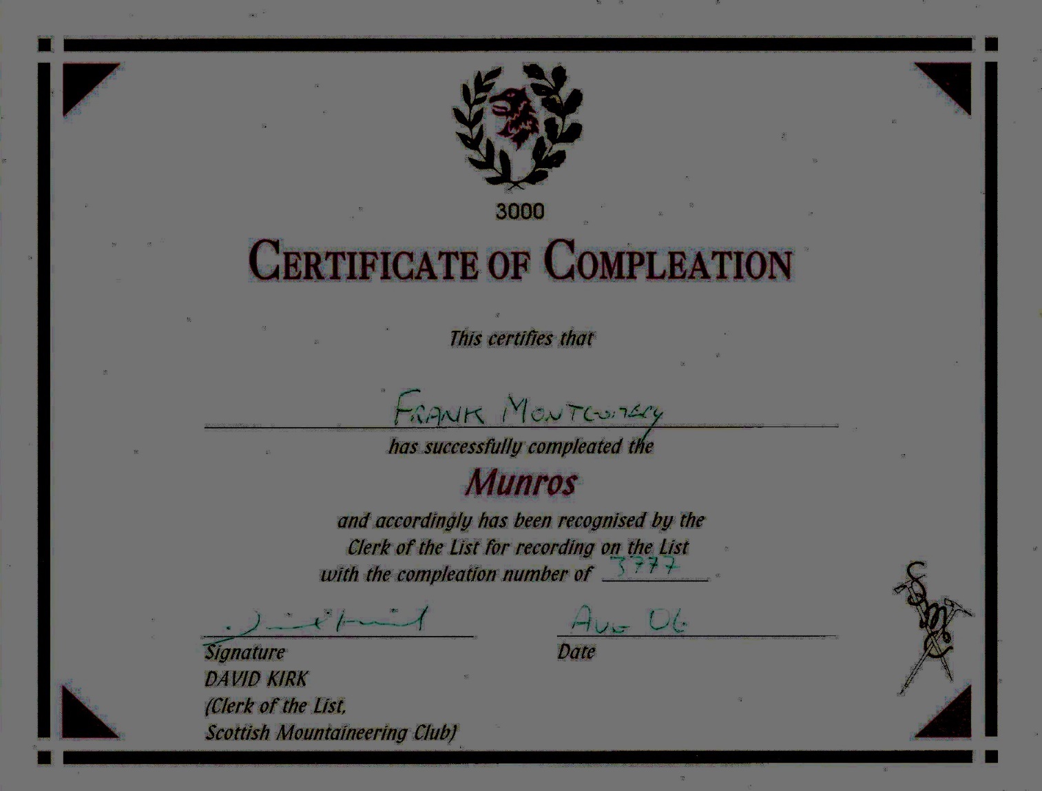
2.
Table of Munros in
Order of Height (at 5 August 2006)
4. My ten favourite Munros
|
Blaven |
5. Number of
Munros climbed with various companions.
|
Solo |
69 |
|
Chris Low |
161 |
|
Geoff Tweddle |
67 |
|
Neil Douglas |
21 |
|
Gerry Quinn |
11 |
|
Matthew Page |
9 |
|
Mark Powell |
6 |
|
Rory Kerr |
5 |
|
Ged Kerr |
4 |
|
Steve Hammond |
4 |
|
Peter Khoo |
3 |
6.